Jenna Santy, University of California, Santa Barbara
The initial ground survey can be one of the more difficult and complicated aspects of an archaeological project. It can require extensive logistical planning and lots of personnel (like people to do the walking!), can be hampered by limited funding (especially for projects in the preliminary stages), and can be physically taxing for the surveyors (survey walkers sometimes go 10 to 14 miles a day or more and traverse steep terrain and thick vegetation).
At times, archaeologists must go into an area with little or no knowledge of what’s there and do their best to get a sense of what archaeological resources are present with limited time and money. When investigating a large region, they must select a sampling strategy that will reveal the most possible information about the region’s resources in an (ideally) accurate initial snapshot of its archaeology given their limitations.
This activity is based on a long-term archaeological study of settlement patterns and environmental resources in the Basin of Mexico (see citations). Your task is to select a sampling strategy, complete your “survey,” and interpret what you find.
Part 1. Map Reading
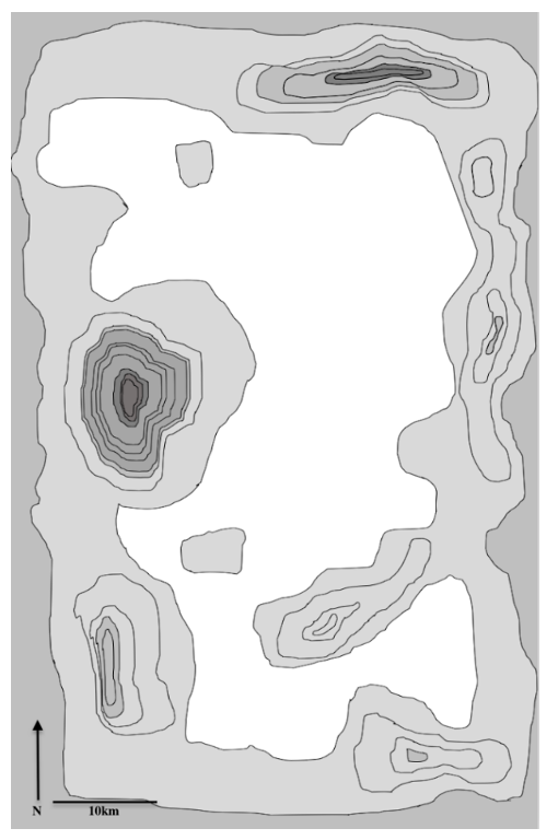
Figure \(\PageIndex{1}\): Topographic map of survey region with North arrow and 10km scale bar.
The area of interest is a now-dry lake bed surrounded by volcanically active mountains. The map you have of the area is a topographic map on which areas of lowest elevation are lightest in color and areas of highest elevation are darkest in color. The lines indicate 100 meters of elevation gain. So when the lines are close together, elevation rises rapidly and is steep; when the lines are further apart, elevation rises more gradually.
Based on the elevation markings, identify which area of the map to the right is the dry lake bed. Draw arrows pointing to the two tallest mountains.
In the bottom right corner of the map is a north arrow indicating how the map should be oriented and a scale bar that shows the length on the map that represents 10 kilometers (km). You will be completing survey blocks that are 10 km by 10 km—10 km2—that are represented by post-it notes (pretend the post-its on your map are perfect squares).
Part 2. Survey Planning
Your survey crew is large—you and 9 other people will be walking. You already know that there are large stone architectural ruins so you will be able to walk pretty wide transects (the section of the survey block one person can walk). The walkers will be spaced at 50 meters (0.05 km) apart.
If you were surveying an area in which the archaeological occupations were more ephemeral, as is the case with most prehistoric sites in California, the spacing would likely be closer to 10 meters apart.
With each person spaced 50 meters (0.05 km) apart, how many people are needed to cover the entire 10 km x 10 km survey block simultaneously? (Yes, sometimes archaeologists have to do math or draw a diagram!)
You do not have this many people available. Your team of 10 can make multiple passes in your block to fully survey the block. How many passes will it take your team to complete the survey of the block?
If your crew can walk 20 km per day, how many days will it take to complete an entire survey block?
You have enough funding to do between 6 and 11 survey blocks for 10-20% coverage; your instructor will tell you exactly how many days’ labor you have funding for.
· Based on the funding you have received, how many blocks will you be able to survey?
Part 3. Sampling
Since this study is in its initial stages, this general survey is mostly a fact-finding, empirical-research endeavor. The purpose of the survey is to learn basic facts about the area. Here’s what you know based on preliminary research.
This is a dry lake bed surrounded by two currently dormant volcanoes.
The sites have remnants of stone-built structures that should be visible on the surface.
The ancient inhabitants of this region were farmers who used ceramics and stone tools.
The culture you’re studying (and the sites you will find) date from 1100 to 1300 AD.
Here’s what you don’t know and some basic questions you’re trying to answer. You may have some guesses, but site settlement data will fill in missing details.
How long has the lake bed been dry and where was its ancient shoreline? Was there a lake when people lived here 900 years ago? You have some guesses, but site settlement data can help you better understand this.
How densely populated was the region and how were people dispersed across the landscape? Are there urban city sites or mostly small farmsteads?
What were the religious beliefs of the region’s inhabitants?
Is there any social hierarchy or inequality among these folks? Evidence of rulers or nobility or social classes?
Sampling
Select a sampling strategy.
You have enough funding to do between 6 and 11 survey blocks, which account for 10–20% coverage of the map. Your instructor will tell you exactly how many you can conduct. You need to decide how you’re going to choose which 10 km blocks to walk. Archaeologists frequently use a variety of strategies, including judgment sampling, a method in which they use their previous knowledge of the region to determine where to survey. In this case, you have minimal previous knowledge, so you will choose one of the following strategies to use. Read all instructions below before pulling any post-its off.
Simple random sampling: Using a random number generator (www.calculatorsoup.com/calculators/statistics/number-generator.php), set Min 1 and Max 55 and generate n = x random numbers according to the number of blocks you get. The post-it in the upper left corner is 1, the upper right corner is 5 and so on.
Stratified random sample: In this technique, you break the region into sub-regions and randomly sample within those sub-regions. This ensures that a range of environments are sampled. Three categories are suggested: lake bed, lake shore, and inland. However, if you can think of others that make more sense, feel free to use them. Just be sure to justify why you did what you did in your write-up.
Decide how you will allot your survey blocks given the categories and which block numbers fall into each category based on the lake outline and the map previously provided and use a random number generator. Once you finish a category (such as the lake bed) and move on to the next one, skip numbers that come up for the completed category and continue generating numbers until you get a block number in a category you haven’t finished yet. For example, if you have surveyed all three of your allotted lake shore blocks (e.g., 39, 27, 9) and the next number you roll is also a lake shore block (e.g., 47), skip that roll and keep rolling until you get a number that’s either lake bed or inland.
You can also choose a combination of these methods, allotting half your blocks to each strategy. Just be sure to explain why you did what you did in your write-up.
Select a strategy and generate your number draws accordingly.
Once you have generated the appropriate number and types of blocks, carefully pull your post-its from those blocks to conduct your survey.
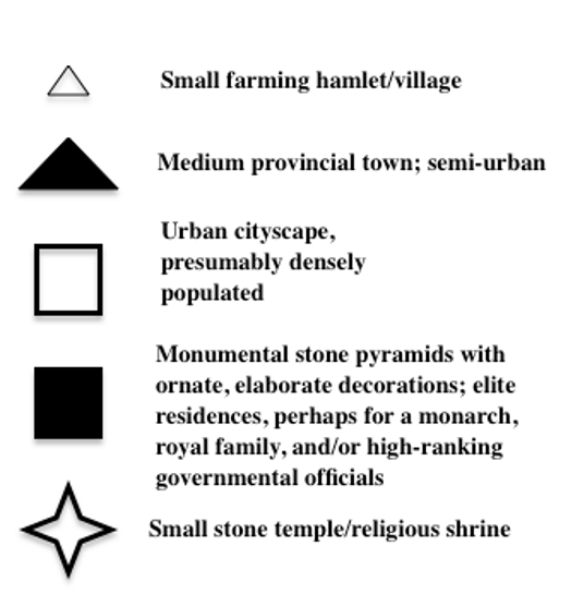
What do you see? Check the following symbol key (Figure \(\PageIndex{2}\)).
Figure \(\PageIndex{2}\)
In your group, discuss how to interpret your results. Next, you will answer questions for your activity write up.
Part 4. Analysis
Prepare a summary of your work, being sure to address each of the following.
What sampling strategy did you choose and why?
Based on where settlements were located, was the lake dry during this period of occupation? Can you discern where a shoreline might have been? How?
How many of each settlement type did you find? Based on this knowledge, was this region more densely populated with some large urban centers or sparsely populated, comprising small farming hamlets with one or two provincial towns?
Did you find any evidence of religion or religious practice? Do you have enough data to generate a hypothesis about the religious beliefs of this society?
Is there any evidence of social hierarchy or political system? If yes, what is it?
Compare your work with that of other groups and then answer the following:
Did the other groups get different results from yours or are your results mostly similar?
How are they different and/or the same?
How was their sampling strategy or coverage amount different?
“The God’s Eye View”
Once you have discussed your interpretations with your group and answered the analysis questions, you will be able to do something that archaeologists conducting partial-coverage ground surveys don’t get to do. They have only the results of the survey (and whatever they come upon during future research) to consult, but you can now view what you would have uncovered if you’d selected other blocks to survey. Pull off ALL the post-its and reveal the true nature of settlement in this region.
What did your survey miss? Was there anything that surprised you? Were your interpretations mostly correct or were they inaccurate?
Was there water in the lake bed during this occupation? Where do you think the lake shore was? Why?
How populated was this region and where are the main population centers located?
Was there a religious system? If so, what did it seem to be linked to?
Is there evidence of social hierarchy or a political system?
Extending what you learned in this assignment, consider the following questions that apply the concepts associated with your survey to broader issues.
Societies that farmed and lived close to volcanoes often developed religious beliefs relating to the volcanoes. Why might this be? (Hint: if you’re unsure, google “volcanic soil agriculture”)
For this exercise, you were looking for sites from a single occupation. In actuality, a region like this with good soil for farming and a water source in prehistory (the lake) would likely have had many occupations, potentially over the course of millennia (as did the Basin of Mexico). What are some ways you could possibly tell sites from different periods apart? (Hint: think about seriation.)
How might you be able to tell different types of sites apart? For example, how do you think you could identify a site as a religious temple rather than an urban dwelling or elite residence?
Archaeologists working today have more methods for early stage research at their disposal than archaeologists working in the past. In addition to a walking survey, what are some ways researchers today can get a sense of what’s on the ground in an area? What advances in technology have facilitated these new methods?
Citations
Sanders, William T., Jeffrey R. Parsons, Robert S. Santley
1979 The Basin of Mexico: Ecological Processes in the Evolution of a Civilization.
Manzanilla, Linda R.
2014 “Chapter 2.19: The Basin of Mexico.” In Cambridge World Prehistory, Colin Renfrew and Paul Bahn, eds., Pp 986–1004. Cambridge University Press; Cambridge, UK.