
10.2: The World's Oceans and Polar Frontiers
- Page ID
- 21110

Over 70 percent of the entire surface of the world is covered with water, but who controls it? If the body of water is inland, ownership is quite clear. A lake in the interior of a state belongs to that state. For the 96.5 percent of the world’s water that’s held in oceans, however, ownership is much less clear. Historically, the world’s oceans were considered the “high seas” and while states had control over their immediate coastline extending out three miles, the vast stretches high seas were free from ownership. As ocean resources became more important, however, countries became interested in establishing clear rights to minerals, oil, and fishing stocks offshore.
In 1945, President Harry S. Truman announced that the sovereign territory of the United States extended to the boundary of its continental shelf, which was in some places hundreds of miles offshore. Other countries, including Chile, Peru, and Ecuador, followed suit, beginning an international dash to claim offshore waters. Within two decades, countries were using a variety of systems of ownership; some claimed waters three miles offshore, others 12 miles, and still others maintained ownership over all of the waters to the continental shelf.
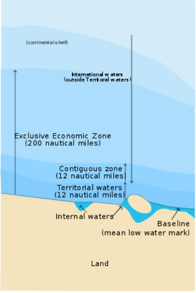
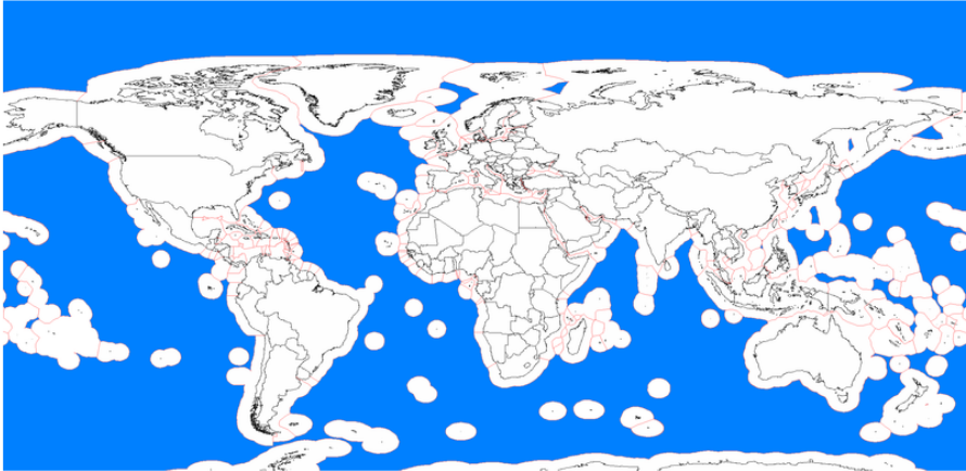
Eventually, the United Nations intervened, seeking a universal system of ocean ownership. The United Nations Convention on the Law of the Sea (UNCLOS) resulted from series of international conferences and established guidelines for maritime travel and control of natural resources found in the world’s seas. As a result of the UNCLOS, there are now several categories of ownership over the world’s water depending on its distance from shore (Figure \(\PageIndex{1}\)). A state’s internal waters are considered the sovereign territory of a state. Territorial waters extended 12 miles offshore and are also considered sovereign territory of a state. However, in territorial waters, a state must grant “innocent passage” to oceangoing vessels, meaning it must allow the vessel to pass through as long as it is doing so in a speedy manner that is not threatening the security of a state. Beyond the territorial waters, a state can control certain aspects of a 12 mile contiguous zone, including taxation and pollution. Following the US claim of control over the continental shelf, the UNCLOS established that a 200 mile zone extending out from a country’s coastline was its exclusive economic zone, or EEZ, where it has exclusive control over any natural resources. Other countries can fly over or pass through the waters of the EEZ, but cannot use the resources within. However, countries are free to sell, lease, or share the rights to their EEZ. Beyond the EEZ are international waters where no state has direct control.
As a result of the UNCLOS, some tiny islands gained immense stretches of ocean territory – and the rights to the resources in and underneath those waters (Figure \(\PageIndex{2}\)). Some countries found this as an opportunity to expand their resource area. Conflicts developed over what would otherwise be tiny specks of island territory but what had become over 100,000 nautical miles of ocean resources. Particularly as the technology for offshore drilling improved, states sought to secure control of what could be huge caches of oil and minerals.
The UNCLOS also established some ownership over the Arctic Ocean. Russia, Norway, Canada, the United States, and Denmark, which controls Greenland, all have overlapping EEZs in the Arctic. Historically, this frigid, isolated region was of little interest to countries. Early attempts at exploration were largely unsuccessful and a person wouldn’t reach the North Pole until the early 20th century. However, the drive to secure fossil fuels has led to more intensive research and exploration in the region and as much as one-quarter of the entire world’s oil and natural gas reserves are believed to lie below Arctic waters. Global increases in temperature could further open up previously inaccessible areas of the Arctic to drilling operations. A 2015 declaration signed by all five states surrounding the Arctic prohibited fishing in the central Arctic Ocean in an effort to protect ocean life and resources.
In the South Pole, Antarctica remains a frontier region with no permanent human inhabitants, though the continent is home to penguins, fur seals, and other marine creatures. Antarctica does have a number of research stations as well as an Orthodox Church and a few thousand people work in and around Antarctica in various times of the year conducting scientific research. Antarctica is the coldest place in the world, once dropping down to -89.2 °C (-128.6 °F) at a Russian research station. Although Antarctica might look relatively moist and snow covered, it is actually a desert with very little precipitation.
So who controls this vast expanse of frozen desert? The answer depends on who you ask. Several different countries claim control of Antarctic territories (Figure \(\PageIndex{3}\)) but, in general, these states do not recognize each other’s claims.
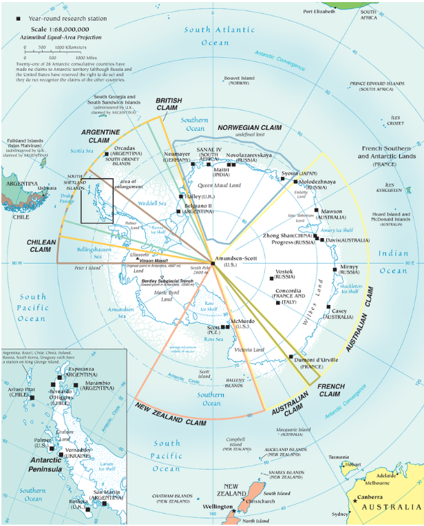
In 1959, the Antarctic Treaty was signed that put a hold on new territorial claims, established Antarctica as a zone for scientific research and environmental protection, and prohibited military activity in the region. A later treaty signed in 1998 reaffirmed Antarctica as a peaceful, scientific frontier and prohibited mining on the continent.
- Territorial waters:
-
an area extending 12 miles offshore that is considered sovereign territory of a state
- Exclusive Economic Zone:
-
a 200 mile zone extending out from a country’s coastline where it has exclusive control over any natural resources, also known as the EEZ