
1.3: Geography of Texas
- Page ID
- 129176
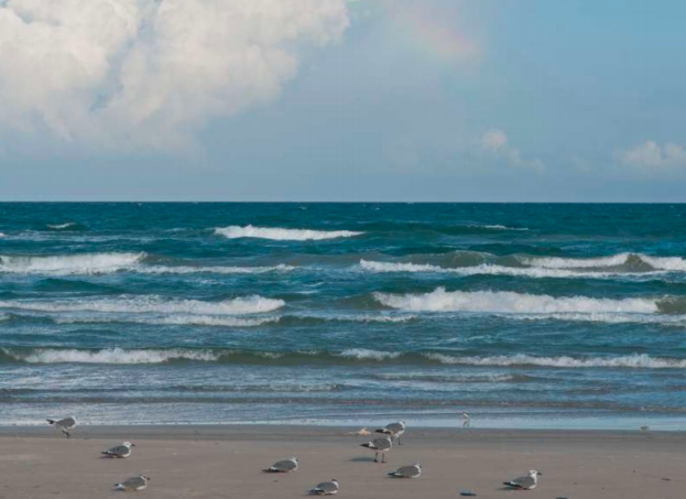
Second only to Alaska, Texas occupies about seven percent of the total water and land area of the United States. The total area of Texas includes 261,232 square miles of land and 7,365 square miles of water. The land and water area of Texas is as large as all of New England, New York, Delaware, Pennsylvania, Ohio, and Virginia combined. It is 801 miles from the northwest corner of the Panhandle to the southern tip of Texas on the Rio Grande River. Traveling from west to east, you would travel 773 miles. Think of it like this—Austin is closer to New Orleans than it is to El Paso and San Diego is closer to El Paso than Houston is. The Rio Grande River travels 889 miles from El Paso to the Gulf of Mexico along the border with Mexico and Texas has 367 miles of beaches on the Gulf of Mexico (Figure 1.3.2).
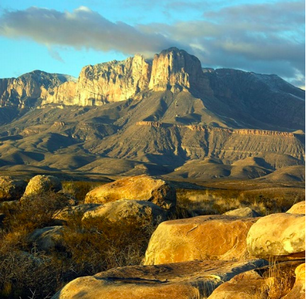
In Guadalupe Mountains National Park in Culberson County, Guadalupe Peak is the highest point in Texas at 8,749 feet and next to it stands El Capitan at 8,085 feet above sea level (Figure 1.3.3). It is also home to scenic McKittrick Canyon, which draws hikers from all over Texas. In the nearby Davis Mountains in Jeff Davis County, Mount Livermore, also known as Baldy Peak, rises 8,378 feet. The highest town in Texas is Fort Davis in Jeff Davis County at 5,050 feet. The highest highway is also in Jeff Davis County at the McDonald Observatory on Mount Locke at 6,781 feet and the highest railway is in Presidio County at 5,074 feet. Sea level is the lowest point in Texas and can be found in all of the coastal counties. As is often said, Texas is a land of contrasts.
The Physical Regions of Texas generally include the Gulf Coastal Plains, the Interior Lowlands, the Great Plains, and the Basin and Range Province (Map 1.3.3).
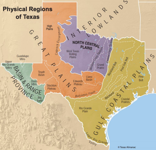
Gulf Coastal Plains
The Gulf Coastal Plains extend from the southernmost tip of Texas to the Red River in the north bordering Oklahoma and east to the Sabine River, bordering Louisiana. The western boundary is the Balcones Fault and Escarpment, a geologic fault extending from a point on the Rio Grande at the city of Del Rio traveling northeast to Bexar, Comal, Hays, and Travis counties joining the Colorado River in Travis county. This fault line is a single geologic feature with southward and eastward facing hills that resemble balconies. The Spanish word balcones means balconies so that is the origin of the name. North of Waco, the fault zone is inconspicuous. Within the Gulf Coastal Plains are six diverse subregions, including the Pine Belt, Post Oak Belt, Blackland Belt, Coastal Prairies, Lower Rio Grande Valley, and Rio Grande Plain.
Pine Belt
The Pine Belt, called the Piney Woods, runs along the eastern border of Texas with Louisiana from the Red River in the north to the Gulf of Mexico in the south. The area was settled early in Texas history and is one of Texas’s oldest farming areas. Its temperate climate and sandy soil produce fruits and vegetables. This is also the location of practically all the commercial timber production in Texas. In addition, cattle is important to the region as well. In the 1880s, John A. Caplan remembered the area around Polk and Hardin counties as an uninhabited area of “tangled underbrush and tall trees”:
There is one continuous dense growth of tall pines, oaks, magnolias and numerous other forest trees. . . . In many places, we have to get down on our hands and knees to crawl through the thick, dose knitted growth of bay, gall bushes, and cane brakes. Not a human being can be seen for miles. Not a voice is heard except our own; and when we pass a grove of pines, the moaning of the wind makes us feel as if Judgment Day was about to come.\(^7\)
The Big Thicket is considered one of the “most biologically diverse areas in the world,” with both cactus and camelias growing in the Big Thicket National Preserve.\(^8\) In addition to lumber, an oil field discovery in 1931 in Gregg, Rusk and Smith counties have done the most to contribute to the economic development of the area. The East Texas Oilfield is the second largest in the contiguous United States.
Post Oak Belt
Bordering the Pine Belt on the west is the Post Oak Belt. Here, the principal industries are farming and livestock raising. Also in this area are the loblolly pines, the second most common species of tree in the United States stretching from East Texas to Florida. Normally found in the Pine Belt, there is a thirteen mile stretch of the Loblolly pines in this region outside Bastrop known as the Lost Pines. Legend tells that an American Indian bride from East Texas became homesick after moving to the area, and her groom returned to her native area and brought back seeds so that she would be surrounded by the trees that she grew up with back home.\(^9\) The word loblolly comes from lob which refers to a thick, bubbling porridge, and lolly is a British word for soup boiled in a pot. In the U.S., the word is used to mean “a mudhole,” and these pines are generally found in the lowlands and swampy areas.
Blackland Belt
Just to the west is the Blackland Belt, which stretches from the Rio Grande to the Red River just below the line of the Balcones Fault. Originally the land was a major cotton producing area and farming area until about the 1930s. Now it is one of the most populated areas in the state, having largest concentration of large and mid-sized cities. Because of the concentration of the population here, it has the most diversified manufacturing industry, including products from petroleum (ExxonMobil in Irving), pharmaceuticals (Reata Pharmaceuticals in Plano, and numerous others throughout the area), Gamestop (Grapevine); batteries (East Penn Manufacturing Company in Temple); flooring (Uzin in Waco), and computers (Dell and Apple in the Round Rock and Austin areas, Texas Instruments in Dallas), among many others.
Coastal Prairies
The Coastal Prairies extends all the way from the Sabine River on the Louisiana border along the coastline to the Rio Grande Valley. They stretch inland twenty to sixty miles and the line between the coastal prairies and the pine belt is very distinct. The grass along this area supports heavy cattle production and rice is grown from the abundance of rivers and wells.
Rice, introduced to Texas by Japanese immigrants in the early 1900s, was reinvented to improve the nutrition and shelf life of rice by Gordon L. Harwell, who perfected a parboiling technique with the research of German scientist Eric Huzenlaub and candy manufacturer Forrest E. Mars.\(^{10}\) Both Mars and Huzenlaub moved to Houston to partner with Harwell to create a company that would eventually become Uncle Ben’s Converted Rice.\(^{11}\) “Uncle Ben” was named after an African-American rice farmer who farmed award-winning rice outside Houston.\(^{12}\)
Industrial development between Houston and Beaumont is primarily petrochemicals and the aerospace industry. As you round the coastal bend from Corpus Christi to Brownsville, both cities have seaports. Cotton, grains, fruit, and vegetables are the most significant crops, and this is the home of the famed King Ranch with major cattle production. The King Ranch was purchased in 1853 by Captain Richard King and today covers over 825,000 acres, an area larger than the state of Rhode Island.
Lower Rio Grande Valley
The rich soils of Lower Rio Grande Valley, and the expansion of irrigation systems in the 1940s, has made agriculture the driving force, in what is known as The Valley. “A mild climate allowed for a year-round growing season that allowed for all kinds of crops to be grown here, but the mainstays have been vegetables, citrus, sugarcane, cotton, and grains,” noted Dr. Merritt Taylor, a former economist at the the Texas A&M AgriLife Center in Weslaco.\(^{13}\) Bordering Mexico, its subtropical climate is not without its problems, however, and vegetable growers work to adapt the varieties of melons, tomatoes, onions, peppers, and other vegetables that are cultivated in the region. The introduction of a mild jalapeno, for example, contributed to the creation of a salsa that now sells more than ketchup.\(^{14}\) In addition, the Valley is the third largest producer of citrus, after California and Florida, in the United States.
Rio Grande Plains
Finally, the Rio Grande Plain lies south of San Antonio and covers the area between the Rio Grande River and the Gulf Coast. Much of the land is prairie, but there is also prickly pear, mesquite, dwarf oak, and other cactus and shrubs. This area is primarily devoted to raising cattle, sheep, and goats. The towns of Laredo and San Antonio are the largest cities. San Antonio is the trade center. Rainfall is less than twenty-five inches annually and the summers are hot, so irrigation is needed for crops.
Interior Lowlands
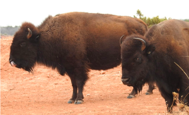
The North Central Plains are part of the Interior Lowlands that extend north all the way to Canada. They border the Blackland Belt on the east and travel west to the Caprock Escarpment. The escarpment is a geologic feature that forms a natural transition between the High Plains in the northern most part of the Texas Panhandle and the western edge of the North Central Plains. This feature stretches for some 200 miles and rises as high as 1,000 feet in some areas. Also found in the North Central Plains is Caprock Canyon State Park, home to one of the state’s largest colonies of free-tailed bats. You can also find herds of buffalo (Figure 1.3.4) and the rare golden eagle in the park. The North Central Plains are sandwiched between the Red River in the north and the Colorado River on the south. There are three major sub-areas in the North Central Plains: Western Rolling Plains; Grand Prairie; and the Eastern and Western Cross Timbers.
Western Rolling Plains
The Western Rolling Plains comprise about two-thirds of this area and rise from about 750 feet on the east to 2,000 feet at the base of the Caprock Escarpment. Annual rainfall falls as one travels west and temperatures have great variation between the heat of summer and the cold of winter. Some of the state’s largest cattle ranches are found in this area.
Grand Prairie
To the east of the Western Rolling Plains lies the Grand Prairie that extends south from the Red River. The area has few trees, but many streams making it adaptable for raising cattle and some staple crops. Some refer to it as the Fort Worth Prairie, this is an agricultural area with a rural population with Fort Worth being the only large city. True to its cattle heritage, Fort Worth—nicknamed Cowtown—has hosted the Southwestern Exposition and Fat Stock Show since 1896 and added indoor events under the Spanish name rodeo (cattle roundup) in 1918.\(^{15}\)
Eastern and Western Cross Timbers
The Eastern and Western Cross Timbers surround the Grand Prairie on the north, east and west. These two southward extending bands are connected at the north by a narrow string along the Red River. The Eastern Cross Timbers travel south through Denton, Dallas and Tarrant counties to the Brazos Rivers and into the Hill Country. The larger Western Cross Timbers travel from the Red River south to the Colorado River and to the Llano Basin. The soils here produce commercial quantities of fruits and vegetable.
Great Plains
The Great Plains lie to the east of the base of the Rocky Mountains and extend into northwestern Texas with the High Plains, and on into the Hill Country of the Edwards Plateau, and the Toyah and Llano Basins.
High Plains
The High Plains is a vast, flat, high plain also known as the Staked Plains or, by its Spanish name, the Llano Estacado. Historians believe that the name could have come from explorer Franciso Vazquez de Coronado’s expedition into the area where he used stakes to mark the route across the endless sea of grass to guide him back. Before making her home in Santa Fe, the painter Georgia O’Keefe taught school in the High Plains and fell in love with its open spaces. Writing to a friend she enthused over the big Texas sky: “The Eastern sky . . . all grey blue . . . nothing but sky and flat prairie land . . . .land that seems more like the ocean than anything else I know. . . . I am loving the plains more than ever it seems—and the SKY. . . you have never seen SKY—it is wonderful.”\(^{16}\)
The High Plains is not only home to skygazers, however; its high elevation also features canyons, including Palo Duro Canyon, the second largest canyon in the U.S. The Palo Duro Canyon is 120 miles long, between six and twenty feet wide, and located on the Prairie Dog Town Fork of the Red River. Other memorable canyons include on the White River and the Canadian Breaks on the Canadian River north of Amarillo.
The Texas High Plains are divided into the Northern and Southern Plains. The Northern Plains are major producers of wheat and grain sorghum, used primarily in livestock feed. Ranching has long been a mainstay of the region’s economy, as have the oil, gas, refining and petrochemical. However, renewable energy has more recently been added, and today the region includes some of the world’s largest wind farms. While wind was recently blamed for power outages in the brutal February blizzard, and temperatures in the High Plains are the traditional conduit for the arctic blue northers that travel across the Great Plains from Canada into Texas, most of the responsibility falls across Texas’s energy grid, including oil, and Texas’s independent power grid, which has no provision to borrow energy outside the state when a crisis occurs. The major city and hub of the Northern High Plains is Amarillo.
The Southern Plains also produces grain sorghum, but in addition, the Southern Plains leads the state in cotton production as well. Lubbock is the major city and Lubbock County is one of the state’s largest cotton producers. Most of the irrigation for the farming comes from underground water reservoirs.
Edwards Plateau
The Edwards Plateau lies between the Rio Grande and the Colorado River and rises from 750 feet to about 2,700 feet. The semi arid plateau is ideal for grazing cattle, goat, and sheep with grass for the cattle, weeds for the sheep, and shrub trees for the goats. It is the nation’s leading Angora goat and mohair producing region and a leader in sheep and wool. Mohair is the fabric or yarn made from the hair of the Angora goat and is known for its high luster and sheen. Along the eastern portion of the Edwards Plateau is an area referred to as the Hill Country. It has several large springs that provide recreational activities including Barton Springs at Austin, San Marcos Springs at San Marcos and Comal Springs at New Braunfels. There are also rugged hills with steep slopes.
Toyah Basin
Located in the Pecos River Valley is the Toyah Basin, a broad flat remnant of an old sea floor. It is thriving now because of local oil fields.
Llano Basin
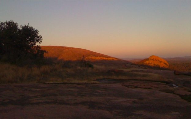
The Llano Basin lies at the junction of the Colorado and Llano Rivers and is home to two large and five small lakes as a result. On the Colorado River, the uppermost lake and one of the largest is Buchanan followed by Inks, L. B. Johnson, and Marble Falls. Lake Travis, the other largest lake is followed by Lake Austin and Lady Bird Lake. All of the lakes are known as the Highland Lakes Country and serve as a major recreational area. Granite domes form the core of ancient rocks, like Enchanted Rock (Figure 1.3.5), located north of Fredericksburg.
Basin and Range Province
The Basin and Range Province has its center in Nevada but enters West Texas from southern New Mexico. This province extends from southern Oregon to western Texas and is an immense region of north-south faulted mountains and flat valley floors. There is nothing like it in the rest of the U.S. It was created about twenty million years ago as the Earth’s crust stretched, thinned, and then broke into some 400 mountain blocks. In Texas, it has New Mexico as the northern border and the Rio Grande River on the south. This is the mountainous region of Texas, although not to be confused with the Rocky Mountains!
Guadalupe Mountains
The Guadalupe Mountains enter Texas from New Mexico and stretch for about twenty miles. This is the home of the highest peak in Texas, Guadalupe Peak at 8,749 feet and next to it sits El Capitan at 8,085 feet. Heading west are the Hueco Mountains lying east of El Paso. The small amount of rainfall falls into a series of salt lakes that are just west of the Guadalupe mountains. They are dry most of the time exposing the salt bottoms. Further west of the Hueco Mountains are the Franklin Mountains in El Paso.
Davis Mountains
The Davis Mountains are mostly in Jeff Davis County and are home to Mount Livermore, also known as Baldy Peak at 8,378 feet, the fourth highest and most isolated peak in Texas, along with several others over 7,000 feet high. The peak is named for Major William Livermore, who in 1884, was in charge of a military expedition to make a map of western Texas for the Engineer Corps. After reaching the top of the bare rock, he called it Old Baldy. This region receives moisture-bearing winds and more rainfall, so there is more vegetation. A distinctive feature in this area is San Solomon Springs, a series of artesian and gravity springs formed by subsurface geologic faults.
Big Bend
As you travel south out of the Davis Mountains, you come to Big Bend country receiving its name because it is bordered by the Rio Grande River on three sides. Mount Emory at 7,825 is the highest peak in Big Bend’s Chisos Mountains. Santa Elena, Mariscal, and Boquillas Canyons are along the Rio Grande River with elevations between 3,500 and 3,775 feet. This area is also home to Big Bend National Park, a popular tourist destination. This national park is known as Texas’s gift to the nation and is considered a magical place. The night skies are as black as coal and the rivers have carved canyons in the limestone. It includes the entire Chisos Mountain Range and a large part of the Chihuahuan Desert.
Upper Rio Grande Valley
The Upper Rio Grande Valley is also known as the El Paso Valley consisting of a strip of irrigated land running along the Rio Grande River for about seventy-five miles south and east of El Paso. Some of the oldest settlements in Texas are located here, including Ysleta, Socorro, and San Elizario founded in the 1680s. The principle crop is a long-staple variety of cotton, known for making sheets, towels, and other quality products.
As you have learned, Texas is geographically very diverse. The same can be said about the politics and the ideology in each of these regions. Right before the 2020 election, the Washington Post published a series of articles on a number of states that could be considered to be swing states during the election. Texas was one of those states, and they called it the “Seven Political States of Texas.”\(^{17}\) The a “Seven Political States of Texas” map in the article looks very similar to the physical regions of Texas.
Political ideology is a coherent set of views on politics and the role of government. The dominant political ideologies in the United States are the liberals on one side and the conservatives on the other side with the moderates in the middle. In general, the liberals, who tend to be Democrats, believe in the positive use of government to bring about change when needed particularly to protect civil liberties and ensure equality. Conservatives, usually associated with the Republican Party, wish to preserve the status quo. They favor reduced governmental interference, tax-cuts and they prefer state government over the federal government. The moderates are those people who fall in the center category between liberals and conservatives. After the adoption of the constitution of 1876, Texas was a dominated by the Democratic Party, but it was still a conservative state. Between the 1970s and the 1990s, Texas saw some two-party competition before the Republican Party became the dominant party. Nevertheless, while Texas is a conservative state, there are variations as you travel across the state.
Looking back at the Washington Post “Seven Political States of Texas” map and their analysis before the election, several questions emerged. Houston and its suburbs had become more Democratic. West Texas (the Basin and Range Province) and the Rio Grande Valley had also become more Democratic. However, polling among Hispanic voters was all over the place and there was wide speculation about their turnout. Many felt that the Hill Country, with liberal Austin in the center, might be more competitive. The Republicans would dominate in North and East Texas, so political pundits across the state had their eyes on Texas.
If we look back to the 2016 election, Hillary Clinton carried five of the most populous counties in Texas which contained the cities of Houston, Dallas, Fort Worth, Austin, and San Antonio. But fifty-seven percent of the total vote in Texas came outside those counties. Texas has millions of rural, White, conservative voters that turned out for Donald Trump where he won by nine points, still a small margin. In the mid-term election of 2018, the Democrats picked up two U.S. House seats and came within five points of winning several statewide races.\(^{18}\) The Democrats had high hopes for the 2020 election, but it did not materialize.
Democrats hoped that a high voter turnout would mean victory, but even with a high turnout of sixty-six percent, the state went for President Trump with about the same percentage of the vote that he secured four years earlier. Because of the COVID-19 pandemic, early voting was extended and most Texans voted early with only thirteen percent voting on the actual election day. Long-time political lobbyist and consultant, Bill Miller said, “Texas has changed somewhat, but it hasn’t changed from its basic nature. The more people that vote, the more it will reflect that.”\(^{19}\) A competitive election between Republicans and Democrats that was expected just did not happen.
- John A Caplan, “Life in the Big Thicket During the 1880s," Traces of Texas, https://tracesoftexas.com/forum/quot...ring-the1880s/.
- Francis E. Abernathy, "The Big Thicket," Texas State Historical Society Handbook of Texas, https://www.tshaonline.org/handbook/...es/big-thicket.
- Rebecca Silvestri, “Lost Pines: Family Fun in the Texas Hill Country,” Connecting Collin County Local Profile, July 16, 2019, https://localprofile.com/2019/07/16/...-hill-country/.
- M.M. Pack, “Japanese Rice in Texas,” Edible Austin, http://www.edibleaustin.com/index.ph...-rice-in-texas; M.M. Pack, “The Story of Uncle Ben’s Converted Rice,” Edible Austin, http://www.edibleaustin.com/index.ph...-rice-in-texas.
- Pack, “Uncle Ben’s,” http://www.edibleaustin.com/index.ph...-rice-in-texas
- Pack, “Uncle Ben’s,” http://www.edibleaustin.com/index.ph...-rice-in-texas.
- Rod Santa Ana, “Agriculture tells the history of the Rio Grande Valley,” AgrLlife Today, Texas A&M University, Jan. 3, 2017, https://agrilifetoday.tamu.edu/2017/...pical%20region %2C%E2%80%9D%20Villal%C3%B3n%20
- Santa Ana, “Rio Grande Valley,” https://agrilifetoday.tamu.edu/2017/...pical%20region %2C%E2%80%9D%20Villal%C3%B3n%20.
- Elizabeth Shurr and Jack P Hagler, “A Brief History of ‘Cowtown’,” Sightlines (July 2013), http://sightlines.usitt.org/archive/...townNoMore.asp.
- Georgia O’Keefe to Anita Politzer (letter), 1916, quoted in “Traces of Texas,” May 27, 2018, Facebook Post, https://www.facebook.com/TracesofTex...8805614818225/.
- . David Weigel, “The Seven Political States of Texas,” The Washington Post, Oct. 4, 2020, https://www.washingtonpost.com/graph...icalgeography/.
- Najmabadi and Cai, “Blue Wave,” https://www.texastribune.org/2020/11...out-democrats/.
- Bill Miller, quoted in Najmabadi and Cai, “Blue Wave,” https://www.texastribune.org/2020/11...out-democrats/.