
4.1: North America's Physical Setting
- Page ID
- 131884
- Identify the key geographic features of North America
- Describe how the process of industrialization shaped North American geography
- Analyze how the patterns of industrialization impacted development in North America
- Describe the current patterns of inequality in the United States
The giant redwoods that stretch over California’s Redwood National Park are the tallest trees on Earth, towering to over 100 meters (328 feet). These trees are also exceptionally old. Indeed, the “General Sherman” is the largest tree in the world by volume and is believed to be over 2,000 years old. At the time General Sherman first emerged from the ground, North America was settled by a number of indigenous groups. It would be 1,000 more years until Europeans would make contact with the Americas. Today, though many of the redwoods still remain, both the physical and human landscapes of North America have profoundly changed.
Traditionally, the continent of North America extends from the Canadian Arctic through the United States and Mexico to the narrow Isthmus of Panama (Figure \(\PageIndex{1}\)). When considering the “region” of North America, there are distinct similarities between Canada and the United States in terms of language and a shared history that are quite different from their Spanish-speaking neighbors to the south. Although the narrow strip of land that typically divides North and South America makes for an easy way to divide these two regions, in many ways, Middle America is largely a transition zone between more powerful economies to the north and south. For example, Mexico culturally resembles countries like Guatemala and Honduras to the south while physiographically resembling the southwestern United States. Thus, the United States and Canada are discussed in the North America chapter while Mexico and Central America are considered alongside the chapter on South America.
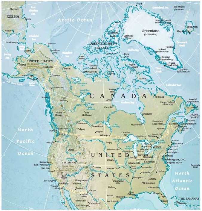
The physiographic regions of North America are well-defined and are commonly recognized by its residents (Figure \(\PageIndex{2}\)). Someone might say he is from “Appalachia” or that she grew up in the “Rocky Mountains.” In general, the physiographic regions have a strong north-south alignment. Climatically, the region is quite diverse, ranging from tundra in northern Canada and Greenland to semi-arid desert in the southwestern United States. These diverse physical conditions have enabled North America to have a wide variety of natural resources, but have also contributed to significant regional differences.
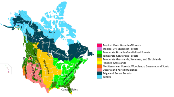
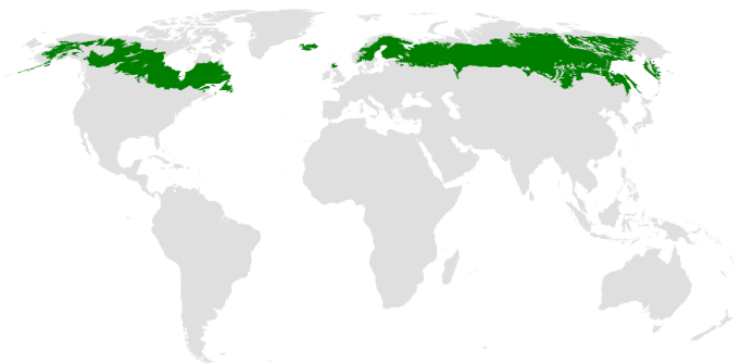
Most of Canada’s land area consists of boreal forest, known as taiga in Russia (Figure \(\PageIndex{3}\)). This boreal forest area consists of coniferous trees, such as spruce and pine, and is characterized by a cold climate. For Canada’s indigenous communities, this large stretch of woodland has been an important resource. The rocky landscape of the Canadian Shield extends from the Arctic regions of Central Canada west through Quebec and is among the oldest geologic formations on Earth. It also has some of the world’s richest mineral areas.
As with the physical landscape, the climate zones of North America are diverse. In general, North America has a relatively simple weather system. As you increase in latitude north, the temperature decreases, and as you travel west to east, the precipitation increases. Thus, California, on the west coast, is relatively warm and dry, while Florida on the east coast is hot and wet.
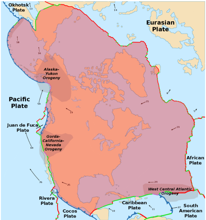
Most of North America, including Mexico, Greenland, and some of the Caribbean, is situated on the North American plate and is thus relatively geologically stable (Figure \(\PageIndex{4}\)). One notable exception is the Juan de Fuca Plate, which is subducting under the North American plate near California and Vancouver Island, an area known as the Cascadia subduction zone. Severe earthquakes that generate tsunamis occur along the plate approximately every 500 years, with the last major earthquake in the area dating to 1700 CE.
Just to the south, the San Andreas Fault runs along the edge of California and forms the boundary between the Pacific Plate and the North American Plate. This is a transform plate boundary, with the two plates sliding past each other horizontally. San Francisco is located on this fault line and the area has experienced numerous earthquakes.
North America has a number of significant rivers, some of which are used for shipping and others for hydroelectric power. The longest North American river is the Missouri, which forms in Montana and flows into the Mississippi River. The Mississippi River is largely considered to be the most important waterway in terms of commercial transportation. The Port of South Louisiana, located along the Mississippi, is the largest port in the United States in terms of tonnage.
Below North America lies a number of aquifers, or underground layers of permeable rock that hold groundwater. The largest is the Ogallala Aquifer located in the central United States stretching from South Dakota down to Texas. This aquifer supplies water to much of the Great Plains – it actually supplies about one-third of all groundwater used for irrigation in the United States. While aquifers are beneficial for irrigation, they replenish their water supplies relatively slowly through rainfall. Depletion of the Ogallala Aquifer has accelerated over the past few decades as water is being taken out of the aquifer at a faster rate than it can be replaced. Once all of the water is depleted, it will take around 6,000 years to naturally replenish. Groundwater conservation initiatives in the area have aimed to slow the depletion rate by encouraging farmers to practice sustainable irrigation methods.
While farmers have been encouraged to conserve water, groundwater depletion is not the only environmental concern. Sustainable agriculture more broadly remains an important initiative. This type of agriculture looks at farming’s effect on the larger ecosystem and seeks to produce agriculture in a way that doesn’t negatively impact the ecosystem in the long-term. It is essentially farming that can be sustained and seeks to minimize water use, soil erosion, and harmful chemicals.
Globally, over one-third of all agricultural land has become degraded due to poor land and resource management. Soil is a finite resource, and topsoil can take over 500 years to form! Traditional forms of agriculture, where you might see large stretches of tilled land, can often lead to topsoil erosion. Through sustainable agricultural practices, soil erosion rates have slowed in the United States over the past several decades.
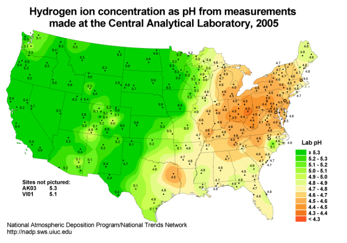
Many environmental problems like topsoil erosion and groundwater depletion affect a wide area and can have far-reaching effects beyond areas where the environment is not being sensitively managed. Acid rain, for example, formed from sulfur dioxide and nitrogen oxide emissions, can have damaging effects far beyond the areas that are emitting these gases (Figure \(\PageIndex{5}\)). When cars or factories burn fossil fuels, those nonrenewable sources of energy formed by the remains of decayed plants or animals, they release a number of chemicals including sulfur and nitrogen. These gases react with water in the atmosphere to form a highly acidic rain that can damage plants and animals.
The lower the pH value, the more acidic a substance is; pure water has a pH of 7. Acid rain can have a pH of around 5.0, or even below 4.0 in some areas. Pickles, by comparison, have a pH of around 5.20, so you can imagine the devastating effects of this acidic precipitation on the environment. The strict regulation of fossil fuel emissions since the 1970s has dramatically reduced instances of acid rain in the United States but some argue that further regulation is needed to address changes in global climate and other pollution concerns.
- Boreal forest:
-
a cold biome characterized by coniferous trees, also known as taiga
- Aquifers:
-
an underground layer of permeable rock that holds groundwater
- Sustainable agriculture:
-
a type of agriculture looks at farming’s effect on the larger ecosystem and seeks to minimize negatively impacts on the ecosystem in the long-term
- Acid rain:
-
a form of acidic precipitation caused by the emission of sulfur dioxide and nitrogen oxide from the burning of fossil fuels
- Fossil fuels:
-
nonrenewable sources of energy formed by the remains of decayed plants or animals