Sites not uncovered by chance or by reviewing archaeological and historical documents are usually detected using three types of reconnaissance: aerial reconnaissance, ground reconnaissance, and subsurface detection. Reconnaissance is the preliminary survey of the site. Basically, it is the initial gathering of information that will inform how to proceed and determine if additional research is needed. Aerial reconnaissance and some subsurface detection methods can be labeled remote sensing. Remote sensing is using methods of reconnaissance that detect subsurface features and sites through the use of devices and technology such as aerial photography, LiDAR, and ground-penetrating radar. Today, archaeologists rely heavily on remote sensing technologies to investigate and study a site in a non-intrusive manner.
reconnaissance
The process of conducting a preliminary survey.
remote sensing
Methods of reconnaissance that detect subsurface features and sites through the use of devices and technology such as aerial photography, LiDAR, and ground-penetrating radar.
Aerial Reconnaissance
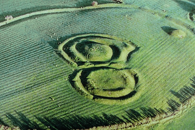
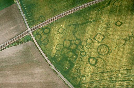
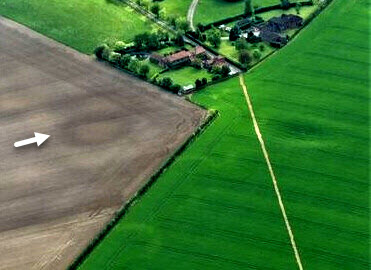
As the name suggests, aerial reconnaissance locates, records, interprets and monitors archaeological sites from above. Aerial photography was first used in archaeology in the early twentieth century and its use expanded significantly after World War I. Archaeologists and their pilots would fly over areas they were interested in investigating, looking for signs of archaeological sites and land formations in which sites or artifacts are commonly found and then photographing them from the air. Aerial reconnaissance is particularly useful when studying large-scale patterns of habitation and the use of a landscape. The photos also sometimes reveal buried sites in a surprising way. Earthworks, crop marks, and soil marks, which are all evidence of human habitation and cultivation, are often apparent in aerial photographs, and trained eyes can identify areas in the images that suggest archaeological remains beneath the surface. For example, earthworks, which consist of buried ditches, banks, and stone walls, often show up as shadows in aerial photos. In the aerial image of The Hill of Tara (Figure 6.2.1 Image 1), you can clearly see the mounds and ditches of the ceremonial and burial mounds that were in use during the Neolithic and Bronze Ages. Crop marks, on the other hand, appear in vegetated areas when plants are growing over buried walls or ditches that stunt or boost their growth relative to the rest of the plants in the area as shown in Figure 6.2.1 Image 2. Soil marks can be revealed when, for example, a plow uncovers a buried stone feature that is close to the surface, exposing a distinct difference in soil color and texture. In Figure 6.2.1 Image 3, the circle of darker soil in the plowed field indicates a former ditch that has been backfilled.
Figure \(\PageIndex{1}\): Aerial Reconnaissance
Image 1: Earthworks - The Hill of Tara, Ireland.
Image 2: Crop Marks - Grézac, France.
Image 3: Soil Marks - Parsonage Farm Lincolnshire, United Kingdom
aerial reconnaissance
A method of locating, recording, interpreting, and monitoring archaeological sites from above.
earthwork
An embankment or construction made of earth that has been created as a result of human activity such as ditches, banks, stone walls, and burial mounds.
crop mark
Archaeological site or feature that is identified from the air by the differential growth in crops and vegetation.
soil mark
Differences in soil color visible in plowed fields resulting from the presence of an archaeological feature such as a former bank or ditch.
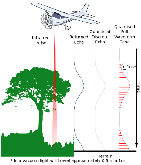
LiDAR
Figure \(\PageIndex{2}\): Sending pulses of light to the surface, LiDAR is used to create 3D topographic maps.
As technologies have changed and developed, new avenues of aerial reconnaissance have opened up. One such technology is Light Detection and Ranging, known as LiDAR, which involves lasers scanning landscapes and sites. An aircraft flies over its target sending pulses of light to the surface and measuring the time it takes to reflect back to the receiver. The receiver collects thousands of data points that can be used to create digital elevation models (DEMs). The models are then used to create 3-dimensional topographic maps of the surface. This technology “sees through” dense vegetation and ground cover to reveal the topography below. This allows archaeologists to identify earthworks, overgrown structures, and other features that are hidden in overgrown forests and jungles.
Recent applications of LiDAR in Mesoamerica have been incredibly successful, leading to the discovery of 60,000 Mayan structures that include homes, fortifications, and causeways. Thanks to this work, we now know that the Mayan world was much more densely populated and interconnected than previously thought. Archaeologists have revised their estimates of the Mayan population to include millions more people in previously unknown city-states.
Light Detection and Ranging (LiDAR)
A technology used to create high-resolution models of ground elevation with a vertical accuracy of 10 centimeters (4 inches) (What is Lidar data and where can I download it?).
Digital Elevation Model (DEM)
A representation of the bare ground (bare earth) topographic surface of the Earth excluding trees, buildings, and any other surface objects (What is a digital elevation model (DEM)?).
Drones, Satellite Imagery, and Google
The availability of drones with photographic equipment attached has dramatically increased the accessibility and affordability of aerial reconnaissance efforts. Archaeologists who once needed to hire a pilot can conduct many aerial reconnaissance flights themselves. However, with the advent of Google Earth, initial reconnaissance flights might not be needed since Google’s satellite imagery is freely available and can often provide necessary aerial images. Since this tool is right at a person’s fingertips, it can be used as a first pass of preliminary reconnaissance, guiding future, more detailed inquiries with techniques that offer a greater resolution. Google Earth also provides historical data through satellite imagery archived over time, allowing archaeologists to compare views of a location, potentially revealing changes in environmental conditions, water levels, and even a site’s condition (before plowing, construction, or some other disturbance).
Since Google Earth is free and drone technology is increasingly affordable, barriers to conducting reconnaissance have decreased, which is good for archaeologists but also allows anyone who is curious to search. Many sites had been protected from disturbance and looting by the fact that they were buried underground or overgrown by the jungle—few people knew they were there. Now, as drone technologies and Google Earth satellite imagery make the search accessible to everyone, sites are being discovered, disturbed, and looted, which is a sad drawback of these scientifically useful modern technologies.
Ground Reconnaissance
Eventually, of course, archaeologists must get out of airplanes and their offices and check out potential sites in person to see what is actually there. They conduct ground reconnaissance to find, record, interpret, and monitor archaeological sites. This type of reconnaissance does not involve excavation. It examines what is visible and accessible directly on the surface of the ground. A primary tool is a surface survey—a systematic search for artifacts by methodically walking the site...that means a lot of walking. How the survey is conducted depends on one’s research question and the specific conditions at a site. Researchers can, for example, consider an area outlined by a trajectory such as a radius or a line extending outward from a central or starting point. The surveyors look for artifact scatter and/or unusual discolorations that suggest prior human behavior. When a possible artifact or feature is identified, the surveyor places a flag in the ground to identify its location and continues surveying. No excavation occurs at this time. Once the survey is complete, the flagged locations are precisely identified by GPS coordinates. Their locations are recorded and artifacts can then be collected, if appropriate, given the research question.
ground reconnaissance
A method of locating, recording, interpreting, and monitoring archaeological sites through observing what is visible and accessible on the surface of the ground.
surface survey
A technique of systematically discovering, gathering, and mapping archaeological data and artifacts found on the surface by methodically walking over the site.
Subsurface Detection
Since the goal of archaeologists is to preserve the archaeological record, they prefer using methods that are non-intrusive and have minimal impact on the integrity of the site. What happens when the features of a site are hidden underground? Thankfully, today's technology provides the tools for subsurface detection and to "see below the ground" without digging. Using remote sensing equipment, archaeologists can identify walls, buildings, and burials that can not be seen from the surface as in the case of the underground crypt in Figure 6.2.6. However, there are times where some digging may be necessary to verify the findings or to understand what is being shown in the data. That is when archaeologists may use probing or test pits for the initial survey of the site.
subsurface detection
Survey techniques used to identify and locate subsurface features including non-intrusive remote sensing technology and techniques that involve minimal destruction to the site such as probing.
Non-intrusive Tools
Archaeologists also have subsurface detection tools that allow them to conduct reconnaissance below the surface of the ground without excavating. One way to do preliminary exploring below the surface is to use a metal detector. However, the most important non-destructive tools are geophysical sensing devices such as Ground Penetrating Radar (GPR). These devices actively probe underground by passing various types of energy, laser, or radio waves through the soil and measuring how the waves are reflected back to find out what is below the surface. Passive geophysical sensing devices measure the physical properties of the soil, such as gravity and magnetism. As with LiDAR, these tools capture data that generate a map of what lies below the surface. These highly technical non-destructive subsurface methods require a trained practitioner capable of running the machines over the site and interpreting the resulting data.
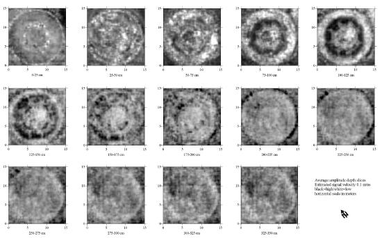
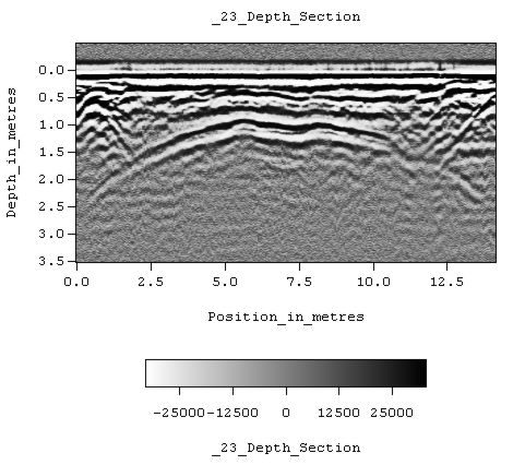
Figure \(\PageIndex{3}\): Ground Penetrating Radar (GPR) images depicting a crypt at a historic cemetery in Saint Paul, Minnesota, USA.
Image 1 (Left): Ground Penetrating radar depth slices of an underground structure. Planview maps isolating specific depth are constructed from many lines of data collected at close intervals.
Image 2 (Right): Ground penetrating radar depth slice. Profile view showing the domed roof of a large subterranean crypt.
Ground Penetrating Radar (GPR)
A geophysical sensing device that uses radar pulses to create an image of subsurface features.
Methods That Disturb The Site
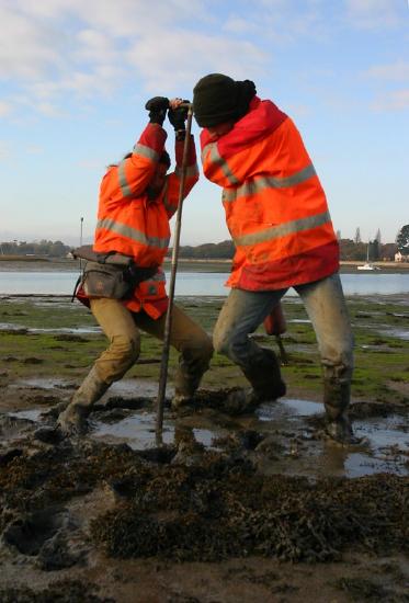
Figure \(\PageIndex{4}\): Archaeologists use an auger to take a sample of sediment during a survey.
As a last resort, archaeologists can use probes that physically dig below the surface to learn more about what lies underground but risk damaging the site. A probe involves using a rod or auger, which looks like a giant drill bit, inserted into the ground to drill down as far as possible into the soil. The auger is then brought back to the surface, carrying with it samples of soil (that may or may not contain artifacts) from various levels below the surface. It is easy to see why this method must be used sparingly and with caution as it involves plunging a sharp, destructive device into the ground, potentially damaging anything it encounters, including human burials. Another method of physically examining the subsurface is making shovel test pits, which are essentially very small excavations, usually smaller than one meter by one meter in size (it varies), to see if there is a potential archaeological site under the surface. Typically, several test pits are opened at the same time at a consistent distance from one another. This method is particularly useful for confirming the results of other forms of reconnaissance.
shovel test pits
A subsurface survey technique involves digging to determine the density and distribution of archaeological remains at a site.
Figure 6.2.1 Image 1 The Hill of Tara, IR. (2019). By Daniel Mennerich under CC BY-NC-SA 2.0 via flickr.
Figure 6.2.1 Image 2 Photo aérienne de GREZAC. (n.d). By cliché J. Dassié under CC BY-SA 3.0 via Wikimedia Commons.
Figure 6.2.1 Image 2 Crop and soil marks in fields by Parsonage Farm near Binbrook: aerial 2021 (2). (2021). By Simon Tomson under CC BY-SA 2.0 via Geograph Britain and Ireland.
Figure 6.2.2 Used to determine the differences in response between full waveform and discrete echo ALS or LIDAR. (2012). By Anthony Beck under CC BY-SA 3.0 via Wikimedia Commons
Figure 6.2.3 Image 1:Ground Penetrating Radar depth slices of an underground structure. (2010). By Tapatio under CC BY-SA 3.0 via Wikimedia Commons.
Figure 6.2.3 Image 2: Ground Penetrating Radar depth slice (profile view) showing the domed roof of a large subterranean crypt in a historic cemetery. (2011). By Tapatio under CC BY-SA 3.0 via Wikimedia Commons.
Figure 6.2.4: Archaeologists use an auger to take a sample of the sediment during a survey of Chichester Harbour. (2005). By Wessex Archaeology under CC BY-NC-SA 2.0 via flickr.
A derivative work from
"Digging into Archaeology: A Brief OER Introduction to Archaeology with Activities" by Amanda Wolcott Paskey and AnnMarie Beasley Cisneros, Faculty (Anthropology) at Cosumnes River College & American River College, ASCCC Open Educational Resources Initiative (OERI), 2020, under CC BY-NC 4.0.