This chapter explores the process of excavation and how it relates directly to the implementation of the archaeologist's research design and the gathering of data to answer the research questions. Perhaps the first truly scientific excavations, in the United States, directed by specific questions about the past were conducted by Thomas Jefferson in 1784 when he dug a trench in a burial mound to discover who had made it and why (see Chapter 2 Section 2.2). This excavation allowed Jefferson to collect data that pointed to Native Americans as the mound builders and indicated that they had used the mound on multiple occasions.
Finally, it’s time to get your hands dirty...well almost. Excavation is not an easy task and not an endeavor to jump into without having a plan. First, it is an expensive proposition in terms of time and financial resources. More importantly, however, it is a destructive technique since the archaeological record is not renewable. If an error is made during the excavation process, the archaeologist cannot undo that work or even redo it—what’s been dug up stays dug up. Kent Flannery, a prominent archaeologist, once quoted a seasoned colleague who said, "Archaeology is the only branch of anthropology where we kill our informants while studying them" (Flannery, 1982). It is critical that nondestructive methods are used whenever possible and that excavation is used only when there is no other way to gather the data needed to accomplish the research goals. With this in mind, the first step in excavation is planning. Archaeologists must ensure that excavation proceeds in a controlled, methodical, and scientific manner. This allows for the preservation of the archaeological record through detailed recording of the data.
Types of Excavation
Excavations can be small in scale, such as the shovel test pits discussed in earlier chapters, or large in scale, such as entire villages or settlements. The scale of excavation units for a study is selected based on the types of questions the researcher hopes to address. The initial research questions will inform the types of excavation needed at the site. Preliminary excavations may answer some research questions and may potentially require researchers to change the scope or even nature of future excavations at the site. Initial findings may lead to the need to dig deeper or to expand the boundaries of the site. It also could be that after initial excavations have been completed, the decision is made that no additional digging is needed because all questions have been answered.
Sampling
The increasing number of CRM projects, costs, and other factors can make it difficult, or unethical, for excavation of the whole site. In these situations, archaeologists are depending on statistical sampling as a means to gather data. Sampling is a very complex topic, so we will only take a very general look at it here. Often, archaeologists will use probabilistic sampling, which is a means of relating small samples of data in mathematical to the larger population. Using this sampling method, the conclusions that are reached based on the sample of artifacts found are considered to be a relatively reliable representation of the site. Random sampling is often used on sites where nothing is known beforehand. A grid of units is set up with random numbers. The numbers are randomly selected for the units that will be excavated. These are only two of the sampling methods an archaeologist may choose. A more in-depth look at sampling methods is beyond the scope of this introductory textbook.
statistical sampling
The science of assessing the reliability of information through the theory of probability.
Site Testing
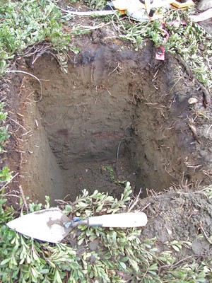
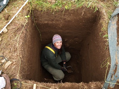
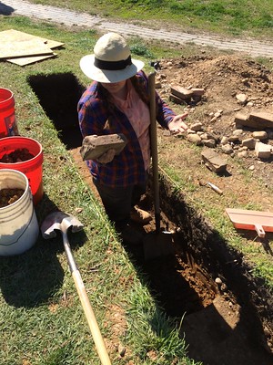
As mentioned in Chapter 6, new technologies in aerial reconnaissance and subsurface detection have become very useful in determining whether a site needs further excavation. However, probing, shovel test pits, test pits, and trenches are used to further explore any subsurface anomalies that may be found as well as define the site boundaries. Test pits are similar to shovel test pits but larger in size. Typically, test pits are the size of an excavation unit, which is normally 1 meter by 1 meter. Sometimes this is referred to as "phone booth archaeology". You can see why in Figure 7.1.2 below. Trenches are useful when there are several anomalies identified through GPR or a need to get a cross-section of a complex site. Site testing is very useful and important in CRM projects.
Figure \(\PageIndex{1}\): Shovel Test PitFigure \(\PageIndex{2}\): Excavation Unit Test PitFigure \(\PageIndex{3}\): Trench Excavation
test pit
An excavation unit used to sample a site before further, more large-scale excavation takes place.
Vertical Excavation
Figure \(\PageIndex{4}\): To establish a chronological sequence, vertical excavation focuses on depth.
If the preliminary sampling and site testing indicate additional excavation is needed. One approach archaeologists can use is vertical excavation, in which trenches or excavation units are deepened to determine the depth of the time scale in the archaeological record. They examine the stratigraphic profiles and the artifacts deposited in the layers to see how long the site was occupied, if it was occupied at different times in history, and whether the culture changed over the course of time in which the site was occupied. Many times, vertical excavations are used for cross-sections of mounds and buildings to establish the timeline of their use.
vertical excavation
Excavations that involve depth to establish the chronological sequence over a limited area.
Horizontal Excavation
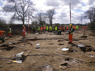
Figure \(\PageIndex{5}\): Horizontal excavations focus on large areas of excavations.
Horizontal excavation, sometimes called area excavation, exposes a large, relatively shallow area to answer questions about the larger site context and function. Typically, horizontal excavations are used to study large-scale regional areas to understand how the use of the environment differed across space. Horizontal excavations usually are not as deep as vertical excavations because time depth is not a critical component in such studies. In most cases, horizontal excavations involve uncovering house plans, settlement layouts, and villages. Burial mounds, hunter-gather campsites, or isolated structures may be completely excavated. However, in the case of large settlements, several portions of the larger area will be excavated to get a sample representation of the site as a whole. Since preservation of the site is the goal, horizontal excavation is carefully monitored and must be consistent with the goals and objectives of the investigation.
horizontal excavation
Excavations designed to expose large areas of a site, especially to uncover settlements. Sometimes called area excavation.
Stratigraphy
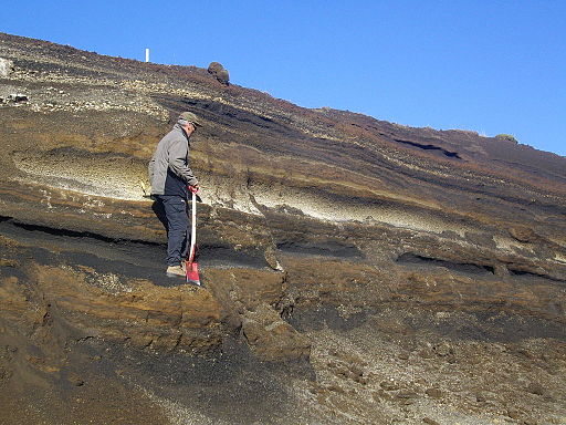
Stratigraphy, the study of layers of soil, is an important component of all excavations but particularly critical for vertical excavations. Stratigraphic data assist archaeologists in putting the archaeological record into context; the data provide a relative way to date the site and its contents and can provide some contextual clues about natural formation processes that occurred after the site was abandoned. For stratigraphy to be used scientifically, the researcher must make two assumptions, both based on the work of Nicolaus Steno, a geologist from the seventeenth century.
Figure \(\PageIndex{6}\): Volcanic tephra horizons in south central Iceland.
The first assumption is that soils accumulate in layers that are laid down horizontally to the Earth’s surface. This is known as the Law of Original Horizontality. This is related to the principle of association (discussed in Chapter 4 Section 4.2). For example, if a site has had multiple occupations, artifacts that are found in the same stratigraphic layer are, by association, assumed to have been deposited during the same occupation of the site.
The second assumption, the Law of Superposition, assumes that older soils will typically (but not always) be found below younger soils. In other words, the old stuff will be on the bottom. These two assumptions allow archaeologists, and others using stratigraphy in their work, to understand how the soils accumulated and to use the layers to “tell time.” Obviously, the artifacts in the bottom layers will be older than those in the top layers. Archaeologists often are on the lookout for a marker horizon when studying stratigraphy. Marker horizons are distinct layers, such as a layer of ash between layers of clay, that provide additional context to the stratigraphic profile or story of the site. Marker horizons can help identify the chronology of artifacts found above and below the horizon.
stratigraphy
The study of rock and soil layers and layering.
Law of Horizontality
Layers of soil or sediment are originally deposited horizontally on the surface of the earth as a result of gravity.
Law of Superposition
A stratigraphic layer laying on top of another is younger than the layer below it.
marker horizon
A distinct layer of soil that provides additional context to the stratigraphic profile.
Mapping the Site
Once archaeologists determine that excavation is needed to answer their research questions, they must tackle several steps. The first step is to map the site and create a grid system is based on the coordinates of a fixed point, the datum or datum point, which is used for all of their future measurements. The datum can be a prominent geographic feature of the site such as a large boulder, building, or fence post to which a GPS point can be affixed. Using an immovable object as the datum point allows future researchers who excavate in the same area to make reference to earlier work.
datum
A set point on the site from which all points are measured, both horizontally and vertically.
Excavation Methods
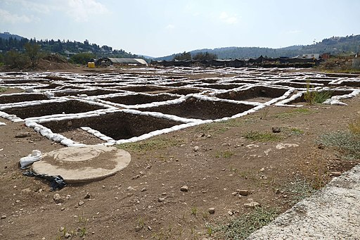
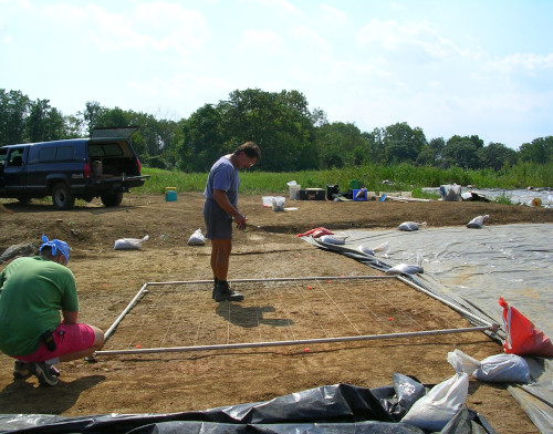
After the site has been mapped, if not already determined in the initial planning phases, an excavation method is selected. The archaeologists consider whether to dig trenches or deep pits in a vertical excavation or a relatively shallow horizontal excavation over a large area of the site. The natural geography, strata, and/or cultural layers will dictate which excavation method is used. Other excavation choices can be dictated by the archaeologists’ training. One method of excavation is Wheeler box grid, which commonly used in other countries other than the United States. It was developed by Mortimer Wheeler when he and his wife, Tessa, were excavating the town of Verulamium, a Roman town located in Britain and inhabited from around 45 BCE to 450 CE. When using the Wheeler box grid method, intact baulks (walls) are left between each grid-square unit so the stratigraphy of the site can be more easily “read.” A balk can vary in size, from 50 centimeters to 2 meters in width depending on the depth of the excavation unit. At the end of the excavation, the baulks are sometimes removed. At times, you may see a site that there are no partitions between the units, but each unit is excavated to a different level. This is another way to gather data on the stratigraphy of each unit. The method that is often used in the United States is open area excavation. Open area excavation still uses a grid system but with no baulks left between the units; the grid squares adjoin each other and are entirely cleared. Often, this method is used when the investigation involves a single occupation of a site.
Figure \(\PageIndex{7}\): Wheeler box gird method at site near Motza, Israel.Figure \(\PageIndex{8}\): Open area excavation in Lancaster County, Pennsylvania.
Wheeler box grid
A method of archaeological excavation that involves using a grid system leaving partitions between units to allow for stratigraphic study.
open area excavation
A method of archaeological excavation that involves opening large areas of a site.
balk
A side wall of an excavation unit or a partition wall between two units. (Plural: baulks)
Figure 7.1.1 Test Pit. (2005). By Travis under CC BY-NC 2.0 via flickr.
Figure 7.1.2 Phone Booth Archaeology. (2004). By Brian Hoffman under CC BY-NC-SA 2.0 via flickr.
Figure 7.1.3 Project archaeologist excavating a trench, Patterson Park. (2014) By Baltimore Heritage under CC BY-SA 2.0 via flickr.
Figure 7.1.4 Wylfa Head Community Excavation. (2017). By Wessex Archaeology under CC BY-NC 2.0 via flickr.
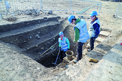
Figure 7.1.5 Excavation at Beanacre, Wiltshire. (2015). By Wessex Archaeology under CC BY-NC 2.0 via Flickr.
Figure 7.1.6 Tephra horizons in south central Iceland. (2009). By Dentren GFDL via Wikimedia Commons.
Figure 7.1.7 Archaeological excavations near Motza, Israel. (2018). By Bukvoed under CC BY 4.0 via Wikimedia Commons.
Figure 7.1.8 Open area excavation in Lancaster County, Pennsylvania. (2005.) By Crystal Scheib under CC BY-NC.
A derivative work from
"Digging into Archaeology:A Brief OER Introduction to Archaeology with Activities" by Amanda Wolcott Paskey and AnnMarie Beasley Cisneros, Faculty (Anthropology) at Cosumnes River College & American River College, ASCCC Open Educational Resources Initiative (OERI), 2020, under CC BY-NC 4.0.