
10.4: Urban Spatial Inequalities in the United States
- Page ID
- 166135
\( \newcommand{\vecs}[1]{\overset { \scriptstyle \rightharpoonup} {\mathbf{#1}} } \)
\( \newcommand{\vecd}[1]{\overset{-\!-\!\rightharpoonup}{\vphantom{a}\smash {#1}}} \)
\( \newcommand{\id}{\mathrm{id}}\) \( \newcommand{\Span}{\mathrm{span}}\)
( \newcommand{\kernel}{\mathrm{null}\,}\) \( \newcommand{\range}{\mathrm{range}\,}\)
\( \newcommand{\RealPart}{\mathrm{Re}}\) \( \newcommand{\ImaginaryPart}{\mathrm{Im}}\)
\( \newcommand{\Argument}{\mathrm{Arg}}\) \( \newcommand{\norm}[1]{\| #1 \|}\)
\( \newcommand{\inner}[2]{\langle #1, #2 \rangle}\)
\( \newcommand{\Span}{\mathrm{span}}\)
\( \newcommand{\id}{\mathrm{id}}\)
\( \newcommand{\Span}{\mathrm{span}}\)
\( \newcommand{\kernel}{\mathrm{null}\,}\)
\( \newcommand{\range}{\mathrm{range}\,}\)
\( \newcommand{\RealPart}{\mathrm{Re}}\)
\( \newcommand{\ImaginaryPart}{\mathrm{Im}}\)
\( \newcommand{\Argument}{\mathrm{Arg}}\)
\( \newcommand{\norm}[1]{\| #1 \|}\)
\( \newcommand{\inner}[2]{\langle #1, #2 \rangle}\)
\( \newcommand{\Span}{\mathrm{span}}\) \( \newcommand{\AA}{\unicode[.8,0]{x212B}}\)
\( \newcommand{\vectorA}[1]{\vec{#1}} % arrow\)
\( \newcommand{\vectorAt}[1]{\vec{\text{#1}}} % arrow\)
\( \newcommand{\vectorB}[1]{\overset { \scriptstyle \rightharpoonup} {\mathbf{#1}} } \)
\( \newcommand{\vectorC}[1]{\textbf{#1}} \)
\( \newcommand{\vectorD}[1]{\overrightarrow{#1}} \)
\( \newcommand{\vectorDt}[1]{\overrightarrow{\text{#1}}} \)
\( \newcommand{\vectE}[1]{\overset{-\!-\!\rightharpoonup}{\vphantom{a}\smash{\mathbf {#1}}}} \)
\( \newcommand{\vecs}[1]{\overset { \scriptstyle \rightharpoonup} {\mathbf{#1}} } \)
\( \newcommand{\vecd}[1]{\overset{-\!-\!\rightharpoonup}{\vphantom{a}\smash {#1}}} \)
\(\newcommand{\avec}{\mathbf a}\) \(\newcommand{\bvec}{\mathbf b}\) \(\newcommand{\cvec}{\mathbf c}\) \(\newcommand{\dvec}{\mathbf d}\) \(\newcommand{\dtil}{\widetilde{\mathbf d}}\) \(\newcommand{\evec}{\mathbf e}\) \(\newcommand{\fvec}{\mathbf f}\) \(\newcommand{\nvec}{\mathbf n}\) \(\newcommand{\pvec}{\mathbf p}\) \(\newcommand{\qvec}{\mathbf q}\) \(\newcommand{\svec}{\mathbf s}\) \(\newcommand{\tvec}{\mathbf t}\) \(\newcommand{\uvec}{\mathbf u}\) \(\newcommand{\vvec}{\mathbf v}\) \(\newcommand{\wvec}{\mathbf w}\) \(\newcommand{\xvec}{\mathbf x}\) \(\newcommand{\yvec}{\mathbf y}\) \(\newcommand{\zvec}{\mathbf z}\) \(\newcommand{\rvec}{\mathbf r}\) \(\newcommand{\mvec}{\mathbf m}\) \(\newcommand{\zerovec}{\mathbf 0}\) \(\newcommand{\onevec}{\mathbf 1}\) \(\newcommand{\real}{\mathbb R}\) \(\newcommand{\twovec}[2]{\left[\begin{array}{r}#1 \\ #2 \end{array}\right]}\) \(\newcommand{\ctwovec}[2]{\left[\begin{array}{c}#1 \\ #2 \end{array}\right]}\) \(\newcommand{\threevec}[3]{\left[\begin{array}{r}#1 \\ #2 \\ #3 \end{array}\right]}\) \(\newcommand{\cthreevec}[3]{\left[\begin{array}{c}#1 \\ #2 \\ #3 \end{array}\right]}\) \(\newcommand{\fourvec}[4]{\left[\begin{array}{r}#1 \\ #2 \\ #3 \\ #4 \end{array}\right]}\) \(\newcommand{\cfourvec}[4]{\left[\begin{array}{c}#1 \\ #2 \\ #3 \\ #4 \end{array}\right]}\) \(\newcommand{\fivevec}[5]{\left[\begin{array}{r}#1 \\ #2 \\ #3 \\ #4 \\ #5 \\ \end{array}\right]}\) \(\newcommand{\cfivevec}[5]{\left[\begin{array}{c}#1 \\ #2 \\ #3 \\ #4 \\ #5 \\ \end{array}\right]}\) \(\newcommand{\mattwo}[4]{\left[\begin{array}{rr}#1 \amp #2 \\ #3 \amp #4 \\ \end{array}\right]}\) \(\newcommand{\laspan}[1]{\text{Span}\{#1\}}\) \(\newcommand{\bcal}{\cal B}\) \(\newcommand{\ccal}{\cal C}\) \(\newcommand{\scal}{\cal S}\) \(\newcommand{\wcal}{\cal W}\) \(\newcommand{\ecal}{\cal E}\) \(\newcommand{\coords}[2]{\left\{#1\right\}_{#2}}\) \(\newcommand{\gray}[1]{\color{gray}{#1}}\) \(\newcommand{\lgray}[1]{\color{lightgray}{#1}}\) \(\newcommand{\rank}{\operatorname{rank}}\) \(\newcommand{\row}{\text{Row}}\) \(\newcommand{\col}{\text{Col}}\) \(\renewcommand{\row}{\text{Row}}\) \(\newcommand{\nul}{\text{Nul}}\) \(\newcommand{\var}{\text{Var}}\) \(\newcommand{\corr}{\text{corr}}\) \(\newcommand{\len}[1]{\left|#1\right|}\) \(\newcommand{\bbar}{\overline{\bvec}}\) \(\newcommand{\bhat}{\widehat{\bvec}}\) \(\newcommand{\bperp}{\bvec^\perp}\) \(\newcommand{\xhat}{\widehat{\xvec}}\) \(\newcommand{\vhat}{\widehat{\vvec}}\) \(\newcommand{\uhat}{\widehat{\uvec}}\) \(\newcommand{\what}{\widehat{\wvec}}\) \(\newcommand{\Sighat}{\widehat{\Sigma}}\) \(\newcommand{\lt}{<}\) \(\newcommand{\gt}{>}\) \(\newcommand{\amp}{&}\) \(\definecolor{fillinmathshade}{gray}{0.9}\)- Explain present-day segregation patterns based on historic and contemporary factors.
- Differentiate between de jure and de facto segregation.
- Analyze the impacts of segregation on spatial inequalities.
Urbanization, Segregation, and Suburbanization
North America’s urban landscape has been shaped both by colonization and by industrialization. Most of the early settlements in the region were small and were located close to the eastern coast. The Appalachian Mountains provided a formidable obstacle for early settlers before 1765. As settlement and colonization expanded, people moved steadily westward, still primarily situated close to waterways. Even today, most urban centers are located close to water.
North American urbanization occurred in distinct eras from the Colonial period where Eastern cities were modeled on European cities through the industrialization era where railroads allowed both Canada and the United States to expand their control westward. “As Europe had sought economic reward through colonization of the [so-called] New World, so, in turn, did the cities of the East Coast seek to enrich themselves through expansion of trade networks with the West”.[1] Immigrants arriving to cities and rural-to-urban migration, especially that of the Great Migration where approximately six million African Americans moved from the South to cities in the north, midwestern, and western states starting in the 1910s, led the United States to have a larger population living in urban areas than in rural ones by 1913.[2] Similarly, industrialization prompted large-scale urban growth where more Canadians lived in cities a decade later. When the period of industrial growth ended after World War II, deindustrialization and the depopulation of urban areas created the suburbs and further segregated populations.
Geographical studies of inequalities are particularly focused on socioeconomic spatial patterns—that is, patterns of identity and class over space. Segregation refers to the physical separation of groups, particularly spaces of residence but also of social life and functions. Segregation is a practice rooted in discriminatory laws. The exclusion of African Americans from schools, workplaces, and neighborhoods was once a core characteristic of American life, legalized by the Supreme Court decision in Plessy v. Ferguson (1896), the case that upheld the "separate but equal" concept by a sanctioning Louisiana law that required African American and white passengers to ride in separate train cars. The Supreme Court reasoned that laws of racial separation were constitutional because separation did not threaten equality. The compounding effects of de jure (by law) and de facto (in practice) efforts to impose white supremacist ideologies and policies helps to explain the sociospatial segregation we see today. While the Civil Rights movement and subsequent laws addressed de jure segregation, we continue to see patterns of segregation today due to historical legacies and de facto segregation. When considering how the past helps us to understand the present, we can utilize a guiding premise that racism and prejudice are entwined with U.S. history and this painful, difficult history must be taught to counter white supremacy.
Defining White Supremacy
White supremacy is a complex concept that manifests both in overt and covert ways. It’s fundamental basis—the existence of a “white race” based in biological differences—is a social construct. Although race is a social construct, it is important to note that it has a powerful impact on people’s lived experiences and identities, and indeed, geographies.
Consider the following quotes:
- Geographers Anne Bonds and Joshua Inwood explain that: “The naturalization and invisibility of white racial identities and white skin privilege is made possible through the structures and logics of white supremacy. If privilege and racism are the symptoms, white supremacy is the disease".[3]
- The National Education Association defines white supremacy culture as “a form of racism centered upon the belief that white people are superior to people of other racial backgrounds and that whites should politically, economically, and socially dominate non-whites. While often associated with violence perpetrated by the KKK and other white supremacist groups, it also describes a political ideology and systemic oppression that perpetuates and maintains the social, political, historical and/or industrial white domination“.[4]
- Laura Pulido, a geography and ethnic studies scholar further elucidates that white supremacy “can be seen in fears of a nonwhite nation, whites’ sense of ownership and the right to exclude, and deeply racialized thinking that systematically undermines the well-being of people of color".[5]
Jim Crow Laws
Jim Crow laws were legislative mandates directed at separating African Americans and white Americas in residence and institutions. From the 1880s into the 1960s, a majority of American states enforced segregation through "Jim Crow" laws (so called after a black character in minstrel shows). From Delaware to California, and from North Dakota to Texas, many states (and cities, too) could impose legal punishments on people for consorting with members of another race. The most common types of laws forbade intermarriage and ordered business owners and public institutions to keep their black and white clientele separated. Below is a sampling of laws from various states.
- In Georgia: “It shall be unlawful for any amateur white baseball team to play baseball on any vacant lot or baseball diamond within two blocks of a playground devoted to the Negro race, and it shall be unlawful for any amateur colored baseball team to play baseball in any vacant lot or baseball diamond within two blocks of any playground devoted to the white race.”
- In Florida: “Any negro man and white woman, or any white man and negro woman, who are not married to each other, who shall habitually live in and occupy in the nighttime the same room shall each be punished by imprisonment not exceeding twelve (12) months, or by fine not exceeding five hundred ($500.00) dollars.”
- In New Mexico: “Separate rooms [shall] be provided for the teaching of pupils of African descent, and [when] said rooms are so provided, such pupils may not be admitted to the school rooms occupied and used by pupils of Caucasian or other descent.”
- In Alabama: “It shall be unlawful to conduct a restaurant or other place for the serving of food in the city, at which white and colored people are served in the same room, unless such white and colored persons are effectually separated by a solid partition extending from the floor upward to a distance of seven feet or higher, and unless a separate entrance from the street is provided for each compartment.
Anti-Miscegenation Laws
Anti-miscegenation laws or miscegenation laws are laws that enforced racial segregation at the level of marriage and intimate relationships by criminalizing interracial marriage and sometimes also sex between members of different races. While there have been no nationwide anti-miscegenation laws in the United States, there were state laws in individual states, particularly in the Southern States and the Plains States, that prohibited miscegenation.
All anti-miscegenation laws banned the marriage of whites and non-white groups, primarily Black Americans, but often also Native Americans and Asian Americans. The first anti-miscegenation law that applied to both men and women was enacted in the colony of Virginia in 1691 and was punishable by exile. It prohibited “English or other white man or woman being free” to intermarry with “a negroe, mulatto, or Indian man or woman bond or free”.[6] Sometimes, the individuals attempting to marry would not be held guilty of miscegenation itself, but felony charges of adultery or fornication would be brought against them instead. In addition, the state of Oklahoma in 1908 banned marriage "between a person of African descent" and "any person not of African descent". Louisiana in 1920 banned marriage between Native Americans and African Americans (and from 1920 to 1942, concubinage as well). Maryland in 1935 banned marriages between Black and Filipino individuals. In many states, anti-miscegenation laws also criminalized cohabitation and sex between whites and non-whites.
After the Second World War, an increasing number of states repealed their anti-miscegenation laws. These laws were a part of American law since before the United States was established and remained so until ruled unconstitutional in 1967 by the U.S. Supreme Court in Loving v. Virginia. Chief Justice Earl Warren wrote in the court majority opinion that: "the freedom to marry, or not marry, a person of another race resides with the individual, and cannot be infringed by the State."
Racially Restrictive Covenants (Deed Covenants)
From at least in the early 1900s to until 1948, individual property owners, homeowners’ associations, and real estate developers employed racially restrictive covenants to prohibit anyone not considered to be part of the “white race” from sale or residency. The only non-white exceptions allowed by most racial covenants were for domestic servants. If a Black renter or homebuyer attempted to move into a house with a restrictive covenant, any white resident in that suburban development could sue to remove them from the neighborhood.
These deed restrictions occurred during the “Streetcar Suburbs” era of urbanization in the United States. This is when trolley lines from downtown areas provided opportunities for the middle-class to move from inner city apartment buildings to more spacious single-family homes. One such housing development occurred in the North Park neighborhood of San Diego. A 1921 advertisement from Stevens & Hartley promoted a location with access to two trolley lines that will take you to “the most up-to-date restricted residence in San Diego”. The fourteenth restriction advertised, just after the restriction on farm animals, provides an example of the language used in racially restrictive covenants:
No conveyance, transfer, or lease of said property, nor any lease of any building that may be placed thereon shall be used or occupied by any person not belonging to the Caucasian race, as owner, lessee or tenant, nor in any other capacity except as servant”.[7]
On May 3, 1948, the U.S. Supreme Court issued its decision that restrictive covenants based on race or ancestry violated the Equal Protection Clause of the 14th Amendment and were legally unenforceable.[8]
Redlining
The economic collapse of the 1930s prompted legislation that created the Home Owners Loan Corporation (HOLC), passed in the first 100 days of the Roosevelt Administration. HOLC helped restructure the American mortgage lending market by creating and standardizing several of its elements. HOLC supported the training of home appraisers and linking a home’s appraisal to the loan that could be given became a widespread practice. HOLC’s department of Research and Statistics drew upon its network of realtors, developers, lenders, and appraisers to create a neighborhood-by-neighborhood assessment of more than 200 cities in the country. These assessments included demographic data, economic reports, and the color-coded Security Maps later deemed infamous as instruments of “redlining.” Loans were refused in areas deemed “hazardous”, often due to the existence of people of color. HOLC assumed and insisted that the residency of African Americans and immigrants, as well as working-class whites, compromised the values of homes and the security of mortgages. In this they followed the guidelines set forth by Frederick Babcock, the central figure in early twentieth-century real estate appraisal standards, in his Underwriting Manual: "The infiltration of inharmonious racial groups ... tend to lower the levels of land values and to lessen the desirability of residential areas." Here are just a few examples from California cities:
- In southeast Fresno, “this large ‘red’ area contains the most mixed population of any part of the City of Fresno. In it are found Japanese, Chinese, negroes, uneducated Italians, and a few representatives of several other races.”
- In south central Los Angeles, a redlined neighborhood was described as “This is the ‘melting pot’ area of Los Angeles, and has long been thoroughly blighted. The Negro concentration is largely in the eastern two thirds of the area.”
- In southeast San Diego, a redlined area was described as a location with “a great many Mexicans with a definite trend of infiltration of this element”.
Mapping Inequality: Redlining in New Deal America provides a GIS tool that integrates the HOLC appraisals across U.S. cities. Figure 10.4.1 shows the HOLC map for Los Angeles. At the time the map was created, 40% of the state’s total population lived in Los Angeles County.[9] Figure 10.4.2 provides 2020 census data by tract for three ethnoracial groups in Los Angeles. The demographic patterns of segregation shown on the maps can be explained, in part, by the de jure and de facto practices of the past.
 Figure \(\PageIndex{1}\): Los Angeles HOLC map. Green shading indicates “best”, where maximum loans of up to 80% of the home appraisal amount would be granted; blue shading indicates “still desirable” where loans up to 65% of the home appraisal amount would be granted; yellow shading indicates “definitely declining” where it was less likely that any loan would be offered; and red shading indicates “hazardous” where loans where refused. (public domain via Mapping Inequality).
 Figure \(\PageIndex{2}\): Percentage of the population that is white (top map), Black or African American (middle map), and Hispanic or Latino (bottom map). (public domain via 2020 Census Demographic Data Map Viewer).
Black Americans criticized HOLC staffing decisions and infrastructure that favored white homeowners and businesses at their expense. However, discussion in Black newspapers, such as the Chicago Defender, prompted only modest response by policy and media elites. The Roosevelt Administration rebuffed NAACP concerns about restrictive covenants, even when HOLC redlining was exposed in 1938. Black housing officials often worked incrementally on a host of issues, including ending white terrorism and getting new black housing built, even if that meant operating within the segregationist strictures of federal policy. Racial segregation in housing was not formally deemed illegal until the Fair Housing Act of 1968, which prohibits discrimination concerning the sale, rental and financing of housing based on race, religion, national origin and sex. On October 14, 2022, the California Association of Realtors issued a formal apology for its past discriminatory policies, including the endorsement of redlining, restrictive covenants, and steering.
Blockbusting
Blockbusting is a technique for increasing real estate brokerage income by playing upon the racial fears of homeowners. The blockbusting broker bought a few properties in an adjacent minority neighborhood then sold it to minority buyers, sometimes at a loss. This was used as a scare fear tactic to solicit white owners to sell quickly to avoid devalued properties later or to have to live among (to them) unattractive neighbors. Sometimes the first minority members were fake buyers brought in to behave as offensively as possible. In effect, the blockbuster is seeking to create a bandwagon effect, a vastly increased volume of panicky home sales, for to gain solely from the increased number of sales commissions and has no regard at all for the ensuing decrease in property values (Figure 10.4.3).

Figure \(\PageIndex{3}\): A 1915 postcard provides an example of blockbusting and the fomenting white fears about African American neighbors from the United Welfare Association showing houses in St. Louis, Missouri. Text on the postcard says: “LOOK at these homes NOW! An entire block ruined by negro invasion. Every house marked “X” now occupied by negroes. ACTUAL PHOTOGRAPHY OF 4300 WEST BELLE PLACE. SAVE YOUR HOME! VOTE FOR SEGREGATION!” (public domain via Missouri Historical Society).
Steering
Steering is another de facto process that segregated neighborhoods. Real estate agents would not show available houses in certain neighborhoods to non-white purchasers or Jewish people. One such example is the La Jolla neighborhood of San Diego. If a real estate agent was showing houses to Jewish buyers, they would put a green card in the window of their car to let the homeowners know their clients were Jewish.[10]
In 1963, the state of California passed the Rumford Fair Housing Act. This law would prohibit housing discrimination against people of color. The following year, the California Association of Realtors (formerly known as the California Real Estate Association) supported a proposition to overturn the Rumford Act so that the state of California could not prevent a person from selling or renting property “to any person as he chooses”. In effect, the proposition allowed for discriminatory practices like steering to continue. The proposition passed with 65 percent of voters in support. In 1967, the U.S. Supreme Court ruled that the proposition was unconstitutional. And, in 1968, the U.S. passed the Fair Housing Act of 1968, which prohibits discrimination concerning the sale, rental and financing of housing based on race, religion, national origin and sex. On October 14, 2022, the California Association of Realtors issued a formal apology for its past discriminatory policies, including the endorsement of redlining, restrictive covenants, and steering.
Impacts of de jure and de facto White Supremacist Policies
White Flight and Suburbanization
The term white flight was coined in the mid-twentieth century to describe suburbanization and the large-scale migration of whites of various European ancestries from racially mixed urban regions to more racially homogeneous suburban regions. Segregation policies such as blockbusting, redlining, and racially restrictive covenants prompted this migration pattern. White flight contributed to the draining of cities’ tax bases when middle-class people left. This contributed to urban decay, a process whereby a city, or part of a city, falls into disrepair and decrepitude. Symptoms of urban decay include depopulation, abandoned buildings, high unemployment, crime, and a desolate, inhospitable landscape. Urban decay was caused in part by the loss of industrial and manufacturing jobs as they moved into rural areas or overseas, where labor was cheaper.
Suburbanization is a term used to describe the growth of areas on the fringes of major cities. Sudden and extreme relocation out of urban areas into the suburbs is one of the many causes of urban sprawl, as suburbs grow to accommodate the increasingly large population. Many residents of suburbs still work within the central urban area, choosing instead to live in the suburbs and commute to work. During World War II, the United States had suffered from a housing shortage, especially in cities with shipyards or large defense plants. Now that the war was over, real estate developers and contractors rushed to alleviate the scarcity. Unused land on the fringes of American cities provided the perfect place for new housing, which attracted not only the middle class, which had long sought homes outside the crowded cities, but also blue-collar workers who took advantage of the low-interest mortgages offered by the Servicemen's Readjustment Act of 1944, known as the G.I. Bill. The vast majority of the 1.2 million African Americans who served the United States during World War II were denied access to the benefits of the G.I. Bill.
An additional factor was the use of prefabricated construction techniques pioneered during World War II, which allowed houses complete with plumbing, electrical wiring, and appliances to be built and painted in a day. Employing these methods, developers built acres of inexpensive tract housing throughout the country. One of the first developers to take advantage of this method was William Levitt, who purchased farmland in Nassau County, Long Island, in 1947 and built thousands of prefabricated houses. The new community was named Levittown.
Levitt’s houses cost only $8,000 and could be bought with little or no down payment. The first day they were offered for sale, more than one thousand were purchased. Levitt went on to build similar developments, also called Levittown, in New Jersey and Pennsylvania. As developers around the country rushed to emulate him, the name Levittown became synonymous with suburban tract housing, in which entire neighborhoods were built to either a single plan or a mere handful of designs. Levitt used racially restrictive deed covenants with potential homeowners to ensure that only whites would live in his communities.
In the decade between 1950 and 1960, the suburbs grew by 46 percent. The transition from urban to suburban life exerted profound effects on both the economy and society. For example, fifteen of the largest U.S. cities saw their tax bases shrink significantly in the postwar period, and the apportionment of seats in the House of Representatives shifted to the suburbs and away from urban areas.
The development of the suburbs also increased reliance on the automobile for transportation. Suburban men drove to work in nearby cities or, when possible, were driven to commuter rail stations by their wives. In the early years of suburban development, before schools, parks, and supermarkets were built, access to an automobile was crucial, and the pressure on families to purchase a second one was strong. As families rushed to purchase them, the annual production of passenger cars leaped from 2.2 million to 8 million between 1946 and 1955, and by 1960, about 20 percent of suburban families owned two cars. The growing number of cars on the road changed consumption patterns, and drive-in and drive-through convenience stores, restaurants, and movie theaters began to dot the landscape. The first McDonald’s opened in San Bernardino, California, in 1954 to cater to drivers in a hurry.
As drivers jammed highways and small streets in record numbers, cities and states rushed to build additional roadways and ease congestion. To help finance these massive construction efforts, states began taxing gasoline, and the federal government provided hundreds of thousands of dollars for the construction of the interstate highway system. Increased funding for highway construction also left less money for public transportation, making it impossible for those who could not afford automobiles to live in the suburbs. The increased construction of roads and highways often fragmented working-class neighborhoods and generated in opposition.[11]
Racial Segregation and Concentrated Poverty: The History of Housing in Black America
This video discusses the de jure and de facto policies that contributed to the formation of ghettoes in the United States.
Education
Prior segregation policies created gaps in the educational system because schools are greatly funded by property taxes. In California, local funding makes up about 33 percent, on average, of educational funding. This means that the wealthier the neighborhood, the higher the taxes and the greater the funding for the school district. States often try to equalize differential funding by giving more funds to poorer districts. Nonetheless, because disadvantaged communities often require supportive services that cost more, the state allocation often does not compensate for the inequality that exists. All in all, where a child lives will determine how much a particular district will spend per student.
School district boundaries many times draw sharp lines between two separate and unequal districts—districts that are predominately white and well-funded and those predominately non-white and underfunded. In the US, there are about 1,000 district borders separating advantaged and disadvantaged school districts. One in six American children attend a disadvantaged school district.
Environmental Racism
In terms of pollution, too, disparities exist across ethnoracial lines. Access of vital resources such as water and clean air is also notably restricted across color lines. For the past several years, Americans have been following the tragic case of Flint, Michigan. Thousands of black and white residents in Flint were exposed to lead contaminated water and the response to such poisoning has been remarkably slow. Disparities in environmental pollution and hazards led to the environmental justice movement.
In 1982, the North Carolina government decided to place 6,000 truckloads of soil containing toxic chemicals in the city of Afton. Afton is a small community located in poor, rural Warren County, North Carolina, and at the time, had an 84 percent African-American population. Protesters against siting the landfill in Afton argued that the siting decision was discriminatory and was made because the community was minority and poor. According to Dr.Robert Bullard, the Afton PCB landfill site was not the most “scientifically suitable location” because of the high risk for groundwater contamination. Throughout six weeks of protest, more than 500 people were arrested. Many veterans of the civil rights movement from the 1950’s and 1960’s supported the protesters and classified the protest as a new fight in the civil rights movement—the fight against environmental racism. Environmental racism refers to “any policy, practice, or directive that differentially affects or disadvantages (whether intended or unintended) individuals, groups, or communities based on race or color.”[12]
Ethnoracial Wealth Gap
The U.S. wealth structure is extremely unequal and marked by very large racial gaps, with the average Black household holding less than one tenth the net worth—defined as the total sum of assets minus debts—of the average white household.[13] The current racial wealth gap is the consequence of many decades of racial inequality that imposed barriers to wealth accumulation either through explicit prohibition during slavery or unequal treatment after emancipation (Figure 10.4.4). Examples of postemancipation barriers include legally mandated segregation in schools and housing, discrimination in the labor market, and redlining, which reduced access to capital in Black neighborhoods.

Black Lives Matter is a global social justice activism movement that began in the United States and has since spread around the globe. The movement seeks to attain racial justice for African-Americans and those who identify as Black. Activists who participate in the movement aim to bring an end to violence and systemic racism aimed against Black people. Since its inception as a hashtag, it has transformed into a full-fledged movement that manifests on and offline. It expanded from being a response to police brutality to encompassing all types of injustices faced by Black people, including in the realms of education, the criminal justice system, and class relations.
The Black Lives Matter movement was created and was solidified in history by the deaths of three African-American men. On February 26th, 2012, Trayvon Martin, a 17-year-old African American high school student was shot and killed by George Zimmerman, a 28 year old mixed Hispanic man at Stanford, Florida. Martin was unarmed and later Zimmerman was charged with second degree murder, however, on July 13th, 2013 he was found not guilty. The shooting of Trayvon Martin and the verdict of the courts caused an outcry from the African American community for action against anti-black racism that permeates today's society. Out of a response to the acquitted Zimmerman, Patrisse Cullors created a hashtag on Facebook in response to a post by Alicia Garza about the incident called, #BlackLivesMatter. Later, Patrisse Cullors in collaboration with Alicia Garza and Opal Tometi started the #BlackLivesMatter campaign. Thus the movement began, in a local grassroots community of Oakland by the work and dreams of Cullors, Garza and Tometi. Yet the movement did not gain national recognition until a year later with the deaths of both Eric Garner and Michael Brown.
On July 17th, 2014, Eric Garner, a 43-year-old African American father of six children, was suffocated to death by Daniel Pantaleo, a 29 year old white policeman at Tompkinsville, Staten Island, New York. Video of the incident was captured on a cell phone and posted on social media, in which protests broke out across the country. This was the beginning of "Black Lives Matter"; supporters began to emerge, using this slogan to protest the police brutality occurring to the Black community. On August 9, 2014, less than a month after the death of Eric Garner, Michael Brown, a unarmed 18-year-old African American teenager, was shot and killed by Darren Wilson, a 28 year old white policeman in Ferguson, Missouri. Hundreds of protests broke out across the country to fight back against police brutality on African American men. #BlackLivesMatter signs were used in all the protests and people started rallying behind this movement.
The Black Lives Matter movement was cemented, and internationally recognized on December 13th when more than 100,000 people came together for the “Justice for all” rally in Washington and “Millions March” rally in NYC to protest police brutality against black people. It was on this stage that launched the Black Lives Matter movement into history. Figure 10.4.5 depicts a mural in Brooklyn, New York, that memorializes some of the Black Americans murdered by police.
.jpg?revision=1) Figure \(\PageIndex{5}\): BLM mural in Brooklyn, New York, by LA Johnson. (CC BY-SA 4.0; by Rhododendrites via Wikimedia).
Figure \(\PageIndex{5}\): BLM mural in Brooklyn, New York, by LA Johnson. (CC BY-SA 4.0; by Rhododendrites via Wikimedia).
Gentrification
Gentrification has gained attention over the last 50 years, as social scientists attempt to explain the influx of middle-class people to cities and neighborhoods and the displacement of lower-class working residents. Gentrification occurs when wealthier people buy or rent property in low- income or working class neighborhoods, driving up property values and rent. While it brings money into blighted urban areas, it often comes at the expense of poorer, pre-gentrification residents who cannot afford increased rents and property taxes.
The first "urban pioneers" in a gentrifying neighborhood may have lower incomes, but possess the cultural capital (e.g., education) characteristic of suburban residents. They are often socially and professionally dominant while economically marginalized. Partially due to their age and low-incomes, these individuals frequently reside in households with roommates and are more tolerant of the perceived evils of the city, such as crime, poor schools, and insufficient public services. Thus, they are willing to move into marginal neighborhoods. When the number of urban pioneers reaches such a critical mass, it attracts business investment and new amenities such as bars, restaurants, and art galleries. Once the urban pioneers and businesses have taken the financial risk out of the community, risk-averse investors and residents may enter the newly gentrified neighborhood. Renewed business attracts more investment capital and new residents, increasing local property values. Ironically, upon full gentrification, the urban pioneers are frequently evicted as rents and taxes rise, and the young, poor professionals can no longer afford to live in the area.
Gentrification is often resisted by those displaced by rising rents (Figure 10.4.6). However, while protests have an economic dimension, claims are usually articulated as a loss of culture or dismay over the homogenization and flattening of a formerly diverse neighborhood: gentrification generally increases the proportion of young, white, middle- to upper-income residents.
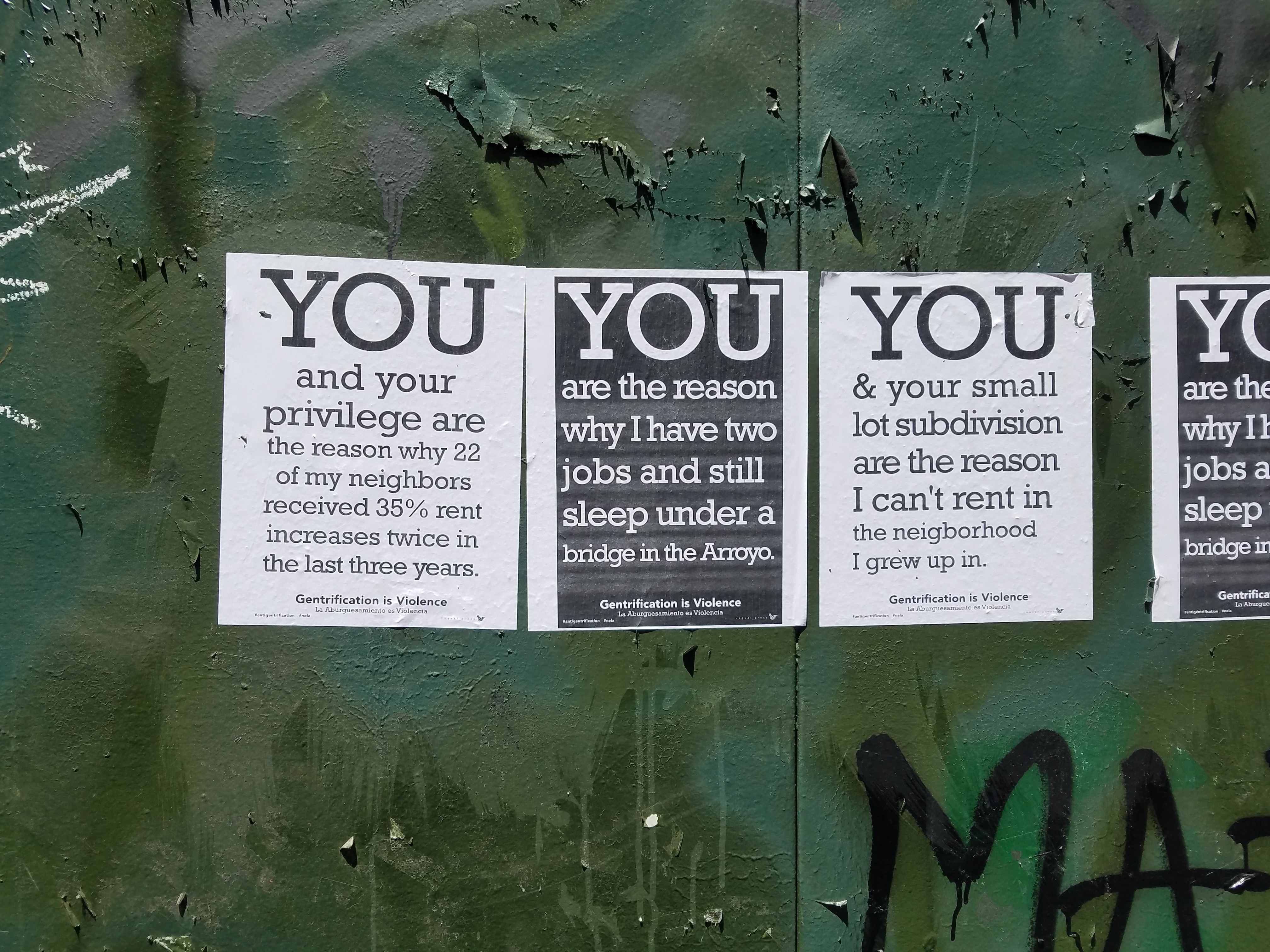
Figure \(\PageIndex{6}\): Flyers posted in protest to gentrification in Lincoln Heights, Los Angeles. The text says “You and your privilege are the reason why 22 of my neighbors received 35 percent rent increases twice in the last three years. You are the reason why I have two jobs and still sleep under a bridge in the Arroyo. You and your small lot subdivision are the reason I can’t rent in the neighborhood I grew up in. (CC BY 2.0; Umberto Brayj via Flickr).
Three different explanations address the root causes of gentrification. The demographic explanation emphasizes the impact of the baby boomer generation, born after World War II. In the 1970s, this led to a spike in the young adult population, increasing demand for housing. To meet the demand, urban areas had to be “recycled,” or gentrified. The new baby boomer residents departed from the suburban family idea, marrying later and having fewer children; women in the baby boomer generation were the first to enter the workforce in serious numbers. New urban residents were composed of higher, dual-income couples without children, less concerned about space for large families—one of the main draws to the suburbs for their parents. Instead, they were interested in living in cities close to their careers and enjoying the amenities their higher incomes could afford.
The sociocultural explanation is based on the assumption that values and beliefs influence behavior. It focuses on the changing lifestyles and values of the middle- and upper-classes in the 1970s. At this time, the suburban ideal was falling out of favor; fewer people were moving to suburbs and more were moving back to cities. These first few suburban transplants, or urban pioneers, demonstrated that cities were viable places to live and began developing a type of inner-city chic that was attractive to other baby boomers, which in turn brought an influx of young affluence to inner cities.
Political economic explanations argue new economic or policy incentives contribute to gentrification. In part, the changing political climate of the 1950s and 1960s produced new civil rights legislation, such as anti-discrimination laws in housing and employment and desegregation laws. These policies enabled Black families to move out of urban centers and into the suburbs, thus decreasing the availability of suburban land, while integrationist policies encouraged white movement into traditionally Black urban areas.
An alternative explanation suggests that developers and government encouraged gentrification with an eye toward profit. Gentrification may be driven by governments hoping to raise property values and increase revenue from taxes. It may be the result of fluctuating relationships between capital investments and the production of urban space. During the two decades following World War II, low rents in the city’s periphery encouraged suburban development; as capital investment moved to suburbs, inner-city property values fell. Developers were able to see that they could purchase the devalued urban land, redevelop the properties, and turn a profit.
References:
[1] Macionis, John J. & Parrillo, Vincent N. 2007. Cities and Urban Life. Upper Saddle River, NJ: Pearson Prentice Hall.
[2] National Archives. 2021. The Great Migration (1910-1970).
[3] Bonds, Anne, & Inwood, Joshua. 2016. Beyond white privilege: Geographies of white supremacy and settler colonialism. Progress in Human Geography, 40(6): 715-733.
[4] National Education Association. 2022. White Supremacy Culture Resources.
[5] Pulido, Laura. 2015. Geographies of race and ethnicity I: White supremacy vs white privilege in environmental racism research. Progress in Human Geography, 39(6): 809-817.
[6] Virginia General Assembly. 1691. ”An act for suppressing outlying slaves”.
[7] Stevens & Hartley. 1912. Hartley’s North Park Addition advertisement. In the collection of the San Diego History Center.
[8] Vinson, F.M. & Supreme Court of the United States. (1947). Shelley v. Kraemer, 334 U.S. 1.
[9] Rey, Sergio Joseph, and Elijah Knapp. (2022). The legacy of redlining: A spatial dynamics perspective. International Regional Science Review, 1-42.
[10] Statthaus, Mary Ellen. 1996. Flaw in the jewel: Housing discrimination against Jews in La Jolla, California. American Jewish History, 84(3): 189-219.
[11] Mohl, Raymond A. 2004. Stop the road: Freeway revolts in American cities. Journal of Urban History, 30(5): 674-706.
[12] Bullard, Robert. 2001. Environmental justice in the 21st century: Race still matters. Phylon, 49(3/4): 151-171.
[13] Oliver, Melvin L., and Thomas M. Shapiro. 2006. Black Wealth, White Wealth. A New Perspective on Racial Inequality. 2nd ed. New York: Routledge.
Attributions:
“Jim Crow Laws” is adapted from Jim Crow Laws by the National Park Service (public domain).
“Anti-Miscegenation Laws” is adapted from Anti-miscegenation Laws by the Scholarly Community Encyclopedia (CC BY-SA 3.0).
“Racially Restrictive Covenants (Deed Covenants)” is adapted from Restricting with Property Covenants by Tracey Wilson, Vianna Iorio, and Jack Dougherty (CC BY-NC-SA 4.0) and Restrictive Covenants by Greg Robinson for the Densho Encyclopedia (CC BY-NC-SA 3.0).
“Redlining” is adapted from Introduction and Mapping Inequality: Redlining in New Deal America by Mapping Inequality (CC BY-NC-SA 4.0).
“Blockbusting” is adapted from Blockbusting by the Legal Dictionaries of the Encyclopedia of Law Project (CC BY 3.0).
“Impacts of de jure and de facto White Supremacist Policies” is adapted from The American Dream by P. Scott Corbett et al. (CC BY-NC).
“White Flight and Suburbanization” is adapted from Shrinking Cities and Counter-Urbanization by LibreText (CC BY-SA 4.0).
“Environmental Racism” is adapted from Environmental Justice: Examining the Environmental Protection Agency’s Compliance and Enforcement of Title VI and Executive Order 12,898 by the U.S. Commission on Civil Rights (public domain).
“Ethnoracial Wealth Gap” is adapted from What Is Behind the Persistence of the Racial Wealth Gap? By Dionissi Aliprantis and Daniel R. Carroll (public domain).
“Black Lives Matter” is adapted from Black Lives Matter by The University of British Columbia (CC BY 4.0).
“Gentrification” is adapted from Urban Gentrification by LibreTexts (CC BY-SA).