3.1: Russia's Physical Geography and Climate
- Page ID
- 21060
\( \newcommand{\vecs}[1]{\overset { \scriptstyle \rightharpoonup} {\mathbf{#1}} } \)
\( \newcommand{\vecd}[1]{\overset{-\!-\!\rightharpoonup}{\vphantom{a}\smash {#1}}} \)
\( \newcommand{\id}{\mathrm{id}}\) \( \newcommand{\Span}{\mathrm{span}}\)
( \newcommand{\kernel}{\mathrm{null}\,}\) \( \newcommand{\range}{\mathrm{range}\,}\)
\( \newcommand{\RealPart}{\mathrm{Re}}\) \( \newcommand{\ImaginaryPart}{\mathrm{Im}}\)
\( \newcommand{\Argument}{\mathrm{Arg}}\) \( \newcommand{\norm}[1]{\| #1 \|}\)
\( \newcommand{\inner}[2]{\langle #1, #2 \rangle}\)
\( \newcommand{\Span}{\mathrm{span}}\)
\( \newcommand{\id}{\mathrm{id}}\)
\( \newcommand{\Span}{\mathrm{span}}\)
\( \newcommand{\kernel}{\mathrm{null}\,}\)
\( \newcommand{\range}{\mathrm{range}\,}\)
\( \newcommand{\RealPart}{\mathrm{Re}}\)
\( \newcommand{\ImaginaryPart}{\mathrm{Im}}\)
\( \newcommand{\Argument}{\mathrm{Arg}}\)
\( \newcommand{\norm}[1]{\| #1 \|}\)
\( \newcommand{\inner}[2]{\langle #1, #2 \rangle}\)
\( \newcommand{\Span}{\mathrm{span}}\) \( \newcommand{\AA}{\unicode[.8,0]{x212B}}\)
\( \newcommand{\vectorA}[1]{\vec{#1}} % arrow\)
\( \newcommand{\vectorAt}[1]{\vec{\text{#1}}} % arrow\)
\( \newcommand{\vectorB}[1]{\overset { \scriptstyle \rightharpoonup} {\mathbf{#1}} } \)
\( \newcommand{\vectorC}[1]{\textbf{#1}} \)
\( \newcommand{\vectorD}[1]{\overrightarrow{#1}} \)
\( \newcommand{\vectorDt}[1]{\overrightarrow{\text{#1}}} \)
\( \newcommand{\vectE}[1]{\overset{-\!-\!\rightharpoonup}{\vphantom{a}\smash{\mathbf {#1}}}} \)
\( \newcommand{\vecs}[1]{\overset { \scriptstyle \rightharpoonup} {\mathbf{#1}} } \)
\( \newcommand{\vecd}[1]{\overset{-\!-\!\rightharpoonup}{\vphantom{a}\smash {#1}}} \)
\(\newcommand{\avec}{\mathbf a}\) \(\newcommand{\bvec}{\mathbf b}\) \(\newcommand{\cvec}{\mathbf c}\) \(\newcommand{\dvec}{\mathbf d}\) \(\newcommand{\dtil}{\widetilde{\mathbf d}}\) \(\newcommand{\evec}{\mathbf e}\) \(\newcommand{\fvec}{\mathbf f}\) \(\newcommand{\nvec}{\mathbf n}\) \(\newcommand{\pvec}{\mathbf p}\) \(\newcommand{\qvec}{\mathbf q}\) \(\newcommand{\svec}{\mathbf s}\) \(\newcommand{\tvec}{\mathbf t}\) \(\newcommand{\uvec}{\mathbf u}\) \(\newcommand{\vvec}{\mathbf v}\) \(\newcommand{\wvec}{\mathbf w}\) \(\newcommand{\xvec}{\mathbf x}\) \(\newcommand{\yvec}{\mathbf y}\) \(\newcommand{\zvec}{\mathbf z}\) \(\newcommand{\rvec}{\mathbf r}\) \(\newcommand{\mvec}{\mathbf m}\) \(\newcommand{\zerovec}{\mathbf 0}\) \(\newcommand{\onevec}{\mathbf 1}\) \(\newcommand{\real}{\mathbb R}\) \(\newcommand{\twovec}[2]{\left[\begin{array}{r}#1 \\ #2 \end{array}\right]}\) \(\newcommand{\ctwovec}[2]{\left[\begin{array}{c}#1 \\ #2 \end{array}\right]}\) \(\newcommand{\threevec}[3]{\left[\begin{array}{r}#1 \\ #2 \\ #3 \end{array}\right]}\) \(\newcommand{\cthreevec}[3]{\left[\begin{array}{c}#1 \\ #2 \\ #3 \end{array}\right]}\) \(\newcommand{\fourvec}[4]{\left[\begin{array}{r}#1 \\ #2 \\ #3 \\ #4 \end{array}\right]}\) \(\newcommand{\cfourvec}[4]{\left[\begin{array}{c}#1 \\ #2 \\ #3 \\ #4 \end{array}\right]}\) \(\newcommand{\fivevec}[5]{\left[\begin{array}{r}#1 \\ #2 \\ #3 \\ #4 \\ #5 \\ \end{array}\right]}\) \(\newcommand{\cfivevec}[5]{\left[\begin{array}{c}#1 \\ #2 \\ #3 \\ #4 \\ #5 \\ \end{array}\right]}\) \(\newcommand{\mattwo}[4]{\left[\begin{array}{rr}#1 \amp #2 \\ #3 \amp #4 \\ \end{array}\right]}\) \(\newcommand{\laspan}[1]{\text{Span}\{#1\}}\) \(\newcommand{\bcal}{\cal B}\) \(\newcommand{\ccal}{\cal C}\) \(\newcommand{\scal}{\cal S}\) \(\newcommand{\wcal}{\cal W}\) \(\newcommand{\ecal}{\cal E}\) \(\newcommand{\coords}[2]{\left\{#1\right\}_{#2}}\) \(\newcommand{\gray}[1]{\color{gray}{#1}}\) \(\newcommand{\lgray}[1]{\color{lightgray}{#1}}\) \(\newcommand{\rank}{\operatorname{rank}}\) \(\newcommand{\row}{\text{Row}}\) \(\newcommand{\col}{\text{Col}}\) \(\renewcommand{\row}{\text{Row}}\) \(\newcommand{\nul}{\text{Nul}}\) \(\newcommand{\var}{\text{Var}}\) \(\newcommand{\corr}{\text{corr}}\) \(\newcommand{\len}[1]{\left|#1\right|}\) \(\newcommand{\bbar}{\overline{\bvec}}\) \(\newcommand{\bhat}{\widehat{\bvec}}\) \(\newcommand{\bperp}{\bvec^\perp}\) \(\newcommand{\xhat}{\widehat{\xvec}}\) \(\newcommand{\vhat}{\widehat{\vvec}}\) \(\newcommand{\uhat}{\widehat{\uvec}}\) \(\newcommand{\what}{\widehat{\wvec}}\) \(\newcommand{\Sighat}{\widehat{\Sigma}}\) \(\newcommand{\lt}{<}\) \(\newcommand{\gt}{>}\) \(\newcommand{\amp}{&}\) \(\definecolor{fillinmathshade}{gray}{0.9}\)- Identify the key geographic features of Russia
- Analyze how the Russian Empire and the Soviet Union approached the issue of ethnic identity
- Describe the current areas of ethnic conflict within Russia
- Explain how Russian history impacted its modern-day geographic landscape
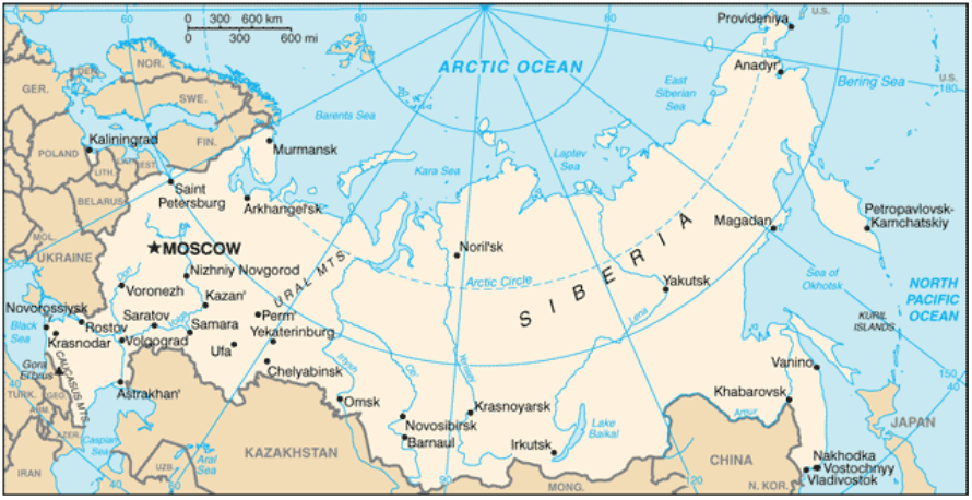
Russia is the largest country in the world, containing 1/8 of the entire world’s land area (Figure \(\PageIndex{1}\)). Russia is also the northernmost large and populous country in the world, with much of the country lying above the Arctic Circle. Its population, however, is comparatively small with around 143 million people, the majority of whom live south of the 60 degree latitude line and in the western portions of Russia near Moscow and Saint Petersburg. Russia stretches across eleven time zones, spanning 6,000 miles from Saint Petersburg on the Baltic Sea to Vladivostok on the Pacific Coast. The country also includes the exclave, or discontinuous piece of territory, of Kaliningrad situated between Poland and Lithuania.

Because of its large size, Russia has a wide variety of natural features and resources. The country is located on the northeastern portion of the Eurasian landmass. It is bordered to the north by the Arctic Ocean, to the east by the Pacific Ocean, and to the south, by the Black and Caspian Seas. The Ural Mountains, running north to south, traditionally form the boundary between Europe and Asia and presented a formidable historical barrier to development. Culturally and physiographically, Western Russia, beyond the Ural Mountains, is quite similar to that of Eastern Europe. The region of Russia east of the Ural Mountains is known as Siberia.
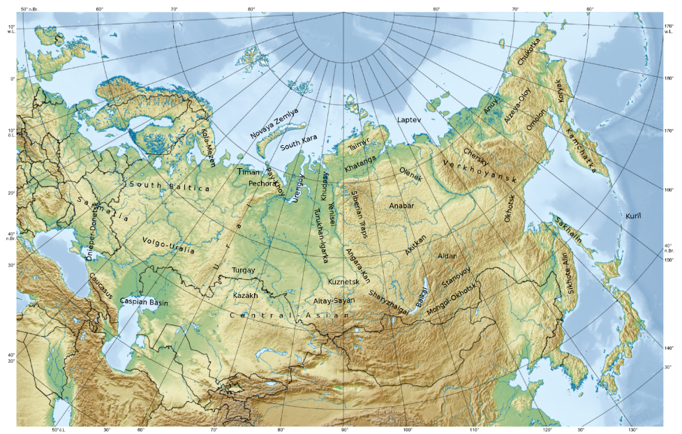
In addition to the Ural Mountains, Russia contains several other areas of high relief (Figure \(\PageIndex{2}\)). Most notably, the Caucasus Mountains, forming the border between Russia and Southwest Asia, and the volcanic highlands of Russia’s far east Kamchatka Peninsula. The western half of Russia is generally more mountainous than the eastern half, which is mostly low-elevation plains.

Russia’s Volga River, running through central Russia into the Caspian Sea, is the longest river on the European continent and drains most of western Russia. The river is also an important source of irrigation and hydroelectric power. Lake Baikal, located in southern Siberia, is the world’s deepest lake and also the world’s largest freshwater lake. It contains around one-fifth of the entire world’s unfrozen surface water. Like the deep lakes of Africa’s rift valley, Lake Baikal was formed from a divergent tectonic plate boundary.
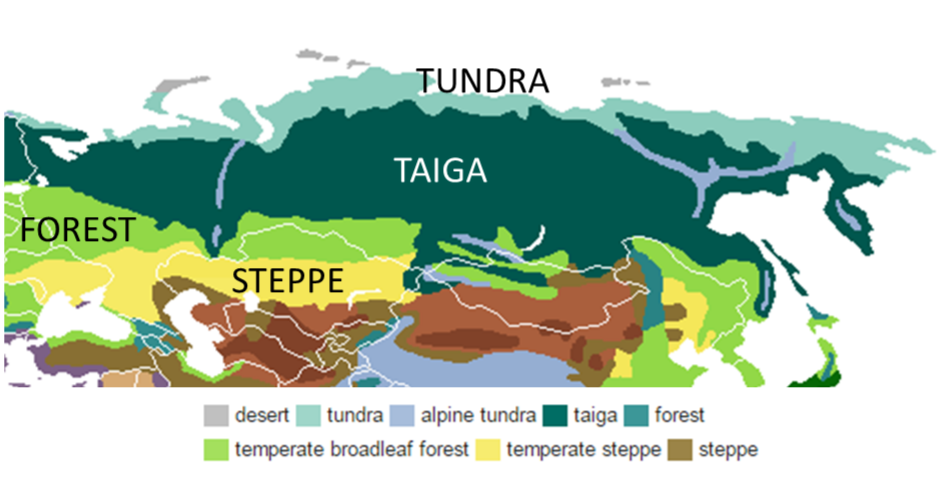
Although Russia’s land area is quite large, much of the region is too cold for agriculture. As shown in Figure \(\PageIndex{3}\), the northernmost portion of Russia is dominated by tundra, a biome characterized by very cold temperatures and limited tree growth. Here, temperatures can drop below -50°C (-58°F) and much of the soil is permafrost, soil that is consistently below the freezing point of water (0°C or 32°F). South of the tundra is the taiga region, where coniferous, snow-capped forests dominate. This area of Russia contains the world’s largest wood resources, though logging in the region has diminished the supply. South of the taiga region are areas of temperate broadleaf forests and steppe, an area of treeless, grassland plains.

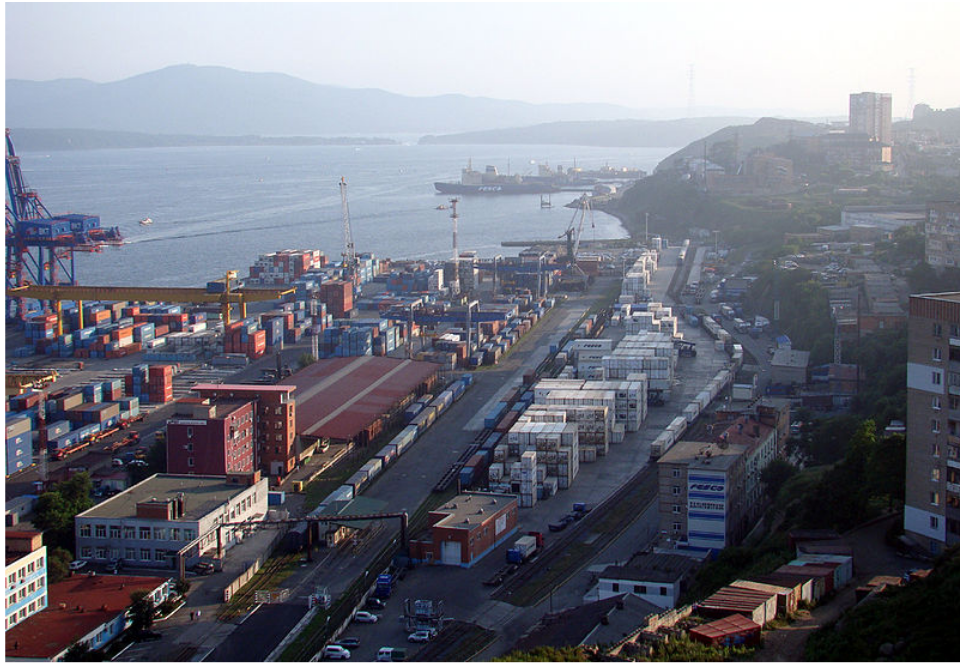
Although looking at a map, you might assume that Russia has extensive port facilities owing to its vast eastern coastline, it actually has relatively few ice-free ports. Vladivostok, located in the extreme southeastern tip of Russia, is its largest port on the Pacific Ocean (Figure \(\PageIndex{4}\)). Much of the rest of Russia’s Far East region is ice-covered throughout the year, making maritime and automotive transport difficult. In fact, this region was only connected to the rest of Russia by highway for the first time in 2010.

Russia’s climate more broadly is affected by a number of key factors. In terms of its latitudinal position, meaning its position relative to the equator, Russia is located very far north. In general, as you increase in latitude away from the equator, the climate gets colder. The strong east-west alignment of Russia’s major biomes reflects this latitudinal influence. Russia’s climate is also affected by its continental position. In general, areas that exhibit a continental are located near the center of a continent away from water bodies and experience more extremes in temperature due to drier air. Water helps regulate air temperature and can absorb temperature changes better than land. In the winter, areas away from water can be very cold, while in the summer, temperatures are quite hot and there is little precipitation. The third key driver of climate in Russia is its altitudinal position. As you increase in elevation, temperatures decrease. You might have experienced this when hiking in mountains or flying on an aircraft and feeling the cold window. Russia’s Ural Mountains, for example, are clearly visible on a map of its biomes as the alpine tundra region owing to its high altitude.
- tundra:
-
a biome characterized by very cold temperatures and limited tree growth
- permafrost:
-
soil that is consistently below the freezing point of water (0°C or 32°F)
- taiga:
-
a biome characterized by cold temperatures and coniferous forests
- steppe:
-
a biome characterized by treeless, grassland plains
- continental climate:
-
areas near the center of a continent that experience more extremes in temperature due to their location away from bodies of water


