
1.4: Geographical Thought- Critical Reflections and Imagination
- Page ID
- 147498
\( \newcommand{\vecs}[1]{\overset { \scriptstyle \rightharpoonup} {\mathbf{#1}} } \)
\( \newcommand{\vecd}[1]{\overset{-\!-\!\rightharpoonup}{\vphantom{a}\smash {#1}}} \)
\( \newcommand{\id}{\mathrm{id}}\) \( \newcommand{\Span}{\mathrm{span}}\)
( \newcommand{\kernel}{\mathrm{null}\,}\) \( \newcommand{\range}{\mathrm{range}\,}\)
\( \newcommand{\RealPart}{\mathrm{Re}}\) \( \newcommand{\ImaginaryPart}{\mathrm{Im}}\)
\( \newcommand{\Argument}{\mathrm{Arg}}\) \( \newcommand{\norm}[1]{\| #1 \|}\)
\( \newcommand{\inner}[2]{\langle #1, #2 \rangle}\)
\( \newcommand{\Span}{\mathrm{span}}\)
\( \newcommand{\id}{\mathrm{id}}\)
\( \newcommand{\Span}{\mathrm{span}}\)
\( \newcommand{\kernel}{\mathrm{null}\,}\)
\( \newcommand{\range}{\mathrm{range}\,}\)
\( \newcommand{\RealPart}{\mathrm{Re}}\)
\( \newcommand{\ImaginaryPart}{\mathrm{Im}}\)
\( \newcommand{\Argument}{\mathrm{Arg}}\)
\( \newcommand{\norm}[1]{\| #1 \|}\)
\( \newcommand{\inner}[2]{\langle #1, #2 \rangle}\)
\( \newcommand{\Span}{\mathrm{span}}\) \( \newcommand{\AA}{\unicode[.8,0]{x212B}}\)
\( \newcommand{\vectorA}[1]{\vec{#1}} % arrow\)
\( \newcommand{\vectorAt}[1]{\vec{\text{#1}}} % arrow\)
\( \newcommand{\vectorB}[1]{\overset { \scriptstyle \rightharpoonup} {\mathbf{#1}} } \)
\( \newcommand{\vectorC}[1]{\textbf{#1}} \)
\( \newcommand{\vectorD}[1]{\overrightarrow{#1}} \)
\( \newcommand{\vectorDt}[1]{\overrightarrow{\text{#1}}} \)
\( \newcommand{\vectE}[1]{\overset{-\!-\!\rightharpoonup}{\vphantom{a}\smash{\mathbf {#1}}}} \)
\( \newcommand{\vecs}[1]{\overset { \scriptstyle \rightharpoonup} {\mathbf{#1}} } \)
\( \newcommand{\vecd}[1]{\overset{-\!-\!\rightharpoonup}{\vphantom{a}\smash {#1}}} \)
- Describe the uneven geographies of knowledge production and identify some of its implications.
- Identify ways in which the co-development of geography as a discipline and colonialism.
- Define race and the ways scientists, including geographers, contributed to the construction of racial hierarchies.
- Explain the concept of the cultural landscape and the turn it represents in the geography discipline.
Racism and Geography: Past and Present
Whose Geography?
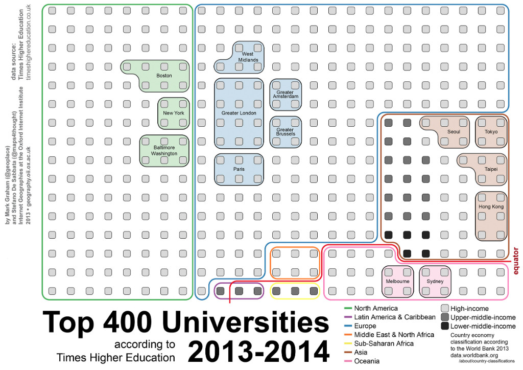
As we approach an introduction to world geographies, it is important that we take a moment to reflect on the stories that we tell, who tells the story, and how our stories perpetuate exclusions and hierarchies.[1] This textbook is a collaboration among authors studied and live in North America, and while we have diverse backgrounds, our geographic situation follows established patterns of knowledge production. For instance, a map of the top 400 universities in the world illustrates that most universities are located within the wealthy countries of North America and Western Europe (See Figure 1.4.1), where most of the world’s academic knowledge is produced. This map provides us a window into the deeply uneven global geography of storytelling and of knowledge production, imbricated in power relationships. Some people have far more control over knowledge than others, and some places are central in information ecosystems whilst others are peripheral.
With the rise of the internet, it has been expected that this will change, that this new platform will disrupt the geographic concentration of access to information and knowledge production. The internet allows billions of users all over the world to access and contribute human knowledge. However, globalized internet access is still an aspiration more so than a reality. There are real geographic inequalities in the digital world. The web is not worldwide as nearly half of the world’s population still does not have access to the internet (although that is changing rapidly), and most internet users cannot freely access or share information due to governmental censorship. People’s uneven contributions on the web can also be see through Wikipedia, the world’s largest and most used user-generated encyclopedia. In theory, Wikipedia allows anyone in the world to submit information to it. In practice, though, we also see massive inequalities in the amount of content submitted to Wikipedia from different parts of the world (See Figure #). Most Wikipedia entries is written by people in rich countries, and only a tiny amount of content comes from elsewhere. This matters because the numerous editors can shape the narrative and the perspectives of entries when writing about contested topics. The uneven access and participation in the digital world reiterate a familiar global power matrix where people in just a few parts of the world seem to have much more voice than everyone else.[2]
Atop these established exclusions, the geography discipline faces the additional problem of being unworldly, a great paradox for a discipline that is concerned with understanding and explaining the world. In line with the patterns of academia at large, geographical knowledge production has been greatly concentrated in North America and Europe, an Anglo-tradition that has been (and still is) largely exclusive of women, LGBTQA+, non-white, and non-Western peoples. Geography departments across colleges and universities in the United States reflect this pattern by being vastly white male dominated.[3] [4] This lack of representation in academic geography deeply shapes the stories that are told, the stories that are not told, and from what point of view – at the detriment of geographers’ work and of geography students seeking to make sense of their worlds.[5] Considering this reality, vigorous scholarly discussions within geography have taken place reflecting on the discipline’s (mis)representations and inequities.[6] [7] Part of this scholarly reckoning has helped geographers first and foremost acknowledge the discipline’s haunting entanglements with colonialism, Eurocentrism, and racism.

Spatial Hierarchies: Imperialism, Colonialism, Eurocentrism
“Geography is a power laden venture…saturated with colonial and imperial themes”- D. Clayton[10]
Geography has deep roots in colonialism and imperialism. Colonialism is a term derived from the Latin word colonia (estate, distant settlement), and it refers to the acquisition and control of other territories. It is a modality of power between a majority (the colonized) and a minority (the colonizer) and takes the form of taking over the life systems of one group of people by another. Settler colonialism is defined as when a group of people claim inhabited land as their own and is often associated with the genocide of Indigenous peoples and the reorganization of the land for the purposes and interests of the settlers. The contemporary world carries a deep legacy of colonization as most of it has been colonized by Europeans over centuries of dispossession in the Americas then later in Africa and Asia – it’s a recent past for many countries in the Caribbean, Africa and South/Southeast Asia that have a short history as independent states.
Colonialism is often used interchangeably with imperialism. Imperialism, a term derived from the Latin word imperium (sovereign authority), means the geographic expansion of power, authority, and dominance either via diplomacy or military. Imperialism is discerned from colonialism as a form of control from a distance, without necessarily entailing the political appropriation and physical occupation of the land. Colonialism was the principal way in which Britain became a powerful empire. “The sun never sets on Britain” is a phrase that encapsulates the extensive global reach of the British Empire, the largest in history. In its peak, it covered nearly a quarter of the world’s land area. Former colonies include Australia, the United States, Canada, New Zealand, Iraq, Malaysia, Kenya, the Bahamas, Jamaica, and India (and the list goes on). Britain’s ambitions of conquest spared only a few places, and only 22 countries in the world today have never been invaded by Britain.[8] Its extensive sphere of influence has deeply transformed peoples and places.

Imperialism did not necessarily end as countries fought and won their independence. For example, as Haiti expelled French colonists, and declared its independence as a Black republic before any country in the Americas or in the colonial world, the French exerted its economic influence to extort millions of dollars from the newly independent Haiti in exchange for its recognition of Haitian sovereignty. Thus, the French Empire exerted power and influence on its former colony, to extract capital from Haiti for nearly seventy years. Today, Haiti is one of the poorest nations in the world.
These long-lasting legacies are also far from solely monetary. In the 1970s there was a rise in Indian and British scholarship around how colonialism had impacted colonized peoples and places. Antonio Gramsci coined the term subaltern, a designation for groups of people who have been systematically excluded from cultural, social, political, and economic decision-making practices. For example, colonized peoples were forced to adopt religious belief systems that were not of their own making, agricultural practices not of their own design, and modes of dress that were imposed upon them from an outside entity. Gramsci understood this as cultural hegemony, where the ruling elite strategically coerces through exploitative tactics to superimpose their cultural ways. This long-lasting legacy is also illustrated by legacies of colonial toponyms, place names. For example, there are 23 Manchesters, 18 Plymouths, and 16 Oxfords throughout the United States, all of which are important places in England.[9] Many of the place names we use in geography today are exonyms, or names given by outside entities, often colonial powers. Exonyms contrast with endonyms, which are how people name their homelands, in their own language and writing.
Geography and the Racist Colonial Project
Colonialism and the building of European empires both enabled and was enabled by geographical knowledge. Cartography, one of geography’s most distinguishing characteristics, was an indispensable tool for identifying, representing, and documenting to-be colonized territories. As discussed in Sect 1.3, maps ware part of the arsenal of weapons of conquest, used to promote colonial interests, to carve up a world that was up for taking. Maps incrementally recorded geographical knowledge about lands largely unknown to Europeans. They were such an invaluable competitive edge that many Spanish and Portuguese maps were empire secrets, like classified documents accessible only to a privileged few.[11]
Geography’s entanglement with empire building is not only in cartography, but also in the discipline’s participation in humanity’s “most dangerous myth”[12]: the construction of race and racism. Race is the categorization of human difference based on perceived physiological traits such as skin color, hair type, head shape, among other features. It is a concept that was once claimed to be scientifically identifiable. The infamous 19th century cranium capacity studies by American scientist Samuel Morton falsely contended that the shape and size of human cranium samples indicated distinctive human races that were directly related to capacity for intelligence. Morton’s work and other reiterations of this scientific myth sought to legitimize a hierarchy of humans highlighting the superiority of what was identified as the Caucasian race. Today, we know race to be a social construct. Scientists, now able to look at humans at the DNA level, have widely discredited the concept of race as scientifically and genetically unfounded. Physically expressed traits are minimal components of a person’s overall genetic makeup and are simply insufficient to create discrete human categories, let alone hierarchies. And, it turns out, genetic traits (like the size of the human head) tend to vary just as much within constructed racial groups as between them. Morton is known as the father of scientific racism, or the ways in which biased “scientific” explanations constructed hierarchies of racial difference.
Morton was not a geographer, but many 19th and 20th century geographers were hard at work to elucidate exotic otherness and racial hierarchies as conventional wisdom. Geographers utilized illustrative work to map “racial types”. Perceived as matter-of-fact documents, maps added a form of scientific legitimacy to racial difference. The fundamental conviction behind many of these maps was that race was not only biological but also an intellectual moral hierarchy that placed Europeans and their descendants at the pinnacle of intelligence and civilization.[13] Racial mappings deserve our attention because they represent the connections geographers were making to race, spatial distributions, and the natural environment – making these connections became a central theme of geography in the United States and Europe for decades to come.
Geography’s main contribution to the racial myth was its attempts to craft a racial science explaining the geographic origins of racial hierarchies, drawing causal relationships between the Earth’s environments and the human genius. Environmental determinism contends that the natural environment predisposes the characteristics of people in each society. The foundational assumption is that nature (the atmosphere, the land, animals, plants, minerals, rocks, and so on) and culture (human beings) are two separate entities, and that the environment largely shapes human beings. Environmental determinism promoted a false claim that the environment or geography of a given place made the humans in that place “more developed” or “less developed.” As such, the logic followed that temperate environments were optimal for the development of ingenious humans, a factor that enabled Europeans to reach great intellectual achievements. Conversely, the tropics, being inhospitably hot and humid, resulted in a hereditary intellectual inertia, dishonesty, and immorality. For decades, such rationale would naturalize race and racial hierarchies, and geographers continued to draw (faux) causal connections between race, climate, environments, intellect, and morality.[14]
Environmental determinism is in reciprocity with Eurocentrism, or the belief, attitude, and ideological apparatus that Europe is at the center of human progress made evident by its economic, political, social systems, and the high quality of life of its citizens. Egyptian-French economist and political scientist Samir Amin coined the term to name an ideological system that perpetuates the so-called superiority of Europe. From a Eurocentric viewpoint, Europe is the center of science, capitalism, democracy, and freedom partially because of its deep ties to Greek and Roman histories. In textbooks, you might see phrases like “the rise of Europe,” and that rise explained in the context of Europe’s rationality, forward thinking, and the benefits of its climate and geography. This Eurocentric approach is also reflected in the vocabulary used to describe colonization as “The Landing of Columbus” (as in he fell from heaven?) or “The Discovery” or “Conquest” of the Americas as “The New World” (as it did not already exist? or as if it was up for conquering?). Eurocentrism is also perpetuated in dichotomies like barbaric vs. civilized, backwards vs. advanced, which only serve as vocabulary claims of racial superiority. Other terminology like Global North vs. Global South, modern vs. traditional, or First World vs. Third World differentiate nations along a continuum of development. While these terms do not essentialize race, they have the same outcome of creating spatial hierarchies with implicit racial associations.
The cartographic and theoretical contributions shortly described here provide examples of the geography discipline as a participant in the proliferation of racism, or the notion of superiority of a constructed race over another. Racism was part of the larger colonial project to establish a racial global hierarchy that recognized human worth in a categorized continuum.[15] Eurocentric explanations of the world dominated (and still dominate) academia and helped justify the subjugation of peoples in colonized territories in a way that did not exist before Columbus. Within less than 200 years of Columbus stumbling upon the Americas, Indigenous populations had been decimated through war and disease and African peoples violently displaced from their homelands and enslaved. The Americas were the first continent to be plundered, depopulated, and repopulated. While religious leaders in both Spain and Portugal were opposed to the eradication of whole groups of people for gold and other resources, they advanced converting of Indigenous people to Christianity. These “civilizing missions” were not opposed to colonization nor racism but rather justified material and cultural theft with religion. Thus, this process of dehumanization and dispossession had been “morally justified” and would continue to proliferate to other parts of the world, deeply traumatizing people and places.[16]

Beyond Environmental Determinism: Human Agency and the Cultural Landscape
Carl O. Sauer (1889-1975), an American geographer, is often credited with countering the claims of environmental determinism in geography with a school of thought centering analysis of human landscapes fashioned by cultural systems. One of the most cited articles in geography is Sauer’s seminal article “The Morphology of Landscape” (1925), an influential work in establishing the concept of the cultural landscape. The cultural landscape as defined by Sauer is “fashioned from a natural landscape by a cultural group. Culture is the agent, nature is the medium, the cultural landscape is the result”.[17] As such, the varied and complex landscapes that make up our world are a result of human culture working as a geographical agent.
Sauer taught at the University of California at Berkeley and was an influential figure in developing the distinctive geography program at Berkeley known as the Berkeley School. Sauer was educated at the University of Chicago and studied with Ellen Churchill Semple (the first woman to serve as president of the Association of American Geographers), an early proponent of environmental determinism. In a direct challenge to environmental determinism, Sauer argued that humans transform physical landscapes to reflect culture and are also influenced by those physical landscapes. Instead of human societies passively being determined by the natural world, Sauer argued that culture, as a collective acquired habit, is a shaping agent of the world around us independent of race. By the time Sauer became president of the AAG in the 1945, WEB Du Bois had already extensively written about race and notions of racial equality and the concept of race as an artifice were already developed in academia.[18]
Sauer’s approach to geography was to first bring the geographer down from the “ivory tower” and into lived spaces to closely study the space in question. Sauer called for a more qualitative, subjective, or creative approach to geographical study. This approach was likely influenced by Alexander von Humboldt (1769-1859), a polymath that contributed significantly to the discipline of geography. Humboldt was active in the 18th and 19th centuries well before Sauer. Humboldt straddled the invisible border between physical and human geography and insisted that art and creativity were central to scientific development. In fact, it has been argued that Humboldt advocated for both “scientific mastery of biological and geophysical processes” in combination with “poetics, aesthetics, emotion, and reason.”[19]
The divide between nature (the physical world and non-humans) and culture (human beings) is questionable, and the relationships of nature and culture is complex. Denis Cosgrove, an influential cultural geographer, says that all landscapes are simultaneously cultural and natural. Indigenous philosophies describe territory as a loving weaving between people and their land.
References:
[1] Kinkaid, E., & Fritzsche, L. (2022). The Stories We Tell: Challenging Exclusionary Histories of Geography in US Graduate Curriculum. Annals of the American Association of Geographers, 112(8), 2469-2485.
[2] Graham, M., Straumann, R. K., & Hogan, B. (2015). Digital divisions of labor and informational magnetism: Mapping participation in Wikipedia. Annals of the Association of American Geographers, 105(6), 1158-1178.
[3] Pulido, L. (2002). Reflections on a white discipline. The Professional Geographer, 54(1), 42-49.
[4] Faria, C., Falola, B., Henderson, J., & Maria Torres, R. (2019). A long way to go: Collective paths to racial justice in geography. The Professional Geographer, 71(2), 364-376.
[5] Faria, C., Falola, B., Henderson, J., & Maria Torres, R. (2019). A long way to go: Collective paths to racial justice in geography. The Professional Geographer, 71(2), 364-376.
[6] Domush, M. 2015. Why is our geography curriculum so white? Association of American Geographers Newsletter.
[7] Kinkaid, E., & Fritzsche, L. (2022). The Stories We Tell: Challenging Exclusionary Histories of Geography in US Graduate Curriculum. Annals of the American Association of Geographers, 112(8), 2469-2485.
[8] Statista (Oct 15, 2021). Only 22 countries have never been invaded by Britain.
[9] Erickson, A. (Jul 4, 2016). Mapping the places in America named after England. The Washington Post.
[10] Clayton, D. W. (2020). The passing of “geography’s empire” and question of geography in decolonization, 1945–1980. Annals of the American Association of Geographers, 110(5), 1540-1558.
[11] Harley, J. B. (2009). Maps, knowledge, and power. Geographic thought: a praxis perspective, 129-148.
[12] Montegu’s Man’s Most Dangerous Myth, as described in Kobayashi, A. (2014). The dialectic of race and the discipline of geography. Annals of the Association of American Geographers, 104(6), 1101-1115.
[13] Winlow, H. (2006). Mapping moral geographies: WZ Ripley's races of Europe and the United States. Annals of the Association of American Geographers, 96(1), 119-141.
[14] Kobayashi, A. (2014). The dialectic of race and the discipline of geography. Annals of the Association of American Geographers, 104(6), 1101-1115.
[15] Esson, J., & Last, A. (2019). Learning and teaching about race and racism in geography. In Handbook for teaching and learning in geography (pp. 227-240). Edward Elgar Publishing.
[16] Mignolo, W. D. (2008). Racism as we sense it today. PMLA, 123(5), 1737-1742.
[17] The Cultural Landscape.
[18] Kobayashi, A. (2014). The dialectic of race and the discipline of geography. Annals of the Association of American Geographers, 104(6), 1101-1115
[19] Hawkins, H. (2019). Geography’s creative (re) turn: Toward a critical framework. Progress in Human Geography, 43(6), 963-984.
Attributions:
"Whose Geography" is adapted from Attribution: Graham, M., De Sabbata, S., Straumann, R., & Ojanpera, S. M. O. (2018). Uneven digital geographies... and why they matter. In This is not an atlas. CC BY 4.0.