
9.2: Indigenous Worlds- Amerindian Civilizations, Colonization, and Revival
- Page ID
- 147539
\( \newcommand{\vecs}[1]{\overset { \scriptstyle \rightharpoonup} {\mathbf{#1}} } \)
\( \newcommand{\vecd}[1]{\overset{-\!-\!\rightharpoonup}{\vphantom{a}\smash {#1}}} \)
\( \newcommand{\dsum}{\displaystyle\sum\limits} \)
\( \newcommand{\dint}{\displaystyle\int\limits} \)
\( \newcommand{\dlim}{\displaystyle\lim\limits} \)
\( \newcommand{\id}{\mathrm{id}}\) \( \newcommand{\Span}{\mathrm{span}}\)
( \newcommand{\kernel}{\mathrm{null}\,}\) \( \newcommand{\range}{\mathrm{range}\,}\)
\( \newcommand{\RealPart}{\mathrm{Re}}\) \( \newcommand{\ImaginaryPart}{\mathrm{Im}}\)
\( \newcommand{\Argument}{\mathrm{Arg}}\) \( \newcommand{\norm}[1]{\| #1 \|}\)
\( \newcommand{\inner}[2]{\langle #1, #2 \rangle}\)
\( \newcommand{\Span}{\mathrm{span}}\)
\( \newcommand{\id}{\mathrm{id}}\)
\( \newcommand{\Span}{\mathrm{span}}\)
\( \newcommand{\kernel}{\mathrm{null}\,}\)
\( \newcommand{\range}{\mathrm{range}\,}\)
\( \newcommand{\RealPart}{\mathrm{Re}}\)
\( \newcommand{\ImaginaryPart}{\mathrm{Im}}\)
\( \newcommand{\Argument}{\mathrm{Arg}}\)
\( \newcommand{\norm}[1]{\| #1 \|}\)
\( \newcommand{\inner}[2]{\langle #1, #2 \rangle}\)
\( \newcommand{\Span}{\mathrm{span}}\) \( \newcommand{\AA}{\unicode[.8,0]{x212B}}\)
\( \newcommand{\vectorA}[1]{\vec{#1}} % arrow\)
\( \newcommand{\vectorAt}[1]{\vec{\text{#1}}} % arrow\)
\( \newcommand{\vectorB}[1]{\overset { \scriptstyle \rightharpoonup} {\mathbf{#1}} } \)
\( \newcommand{\vectorC}[1]{\textbf{#1}} \)
\( \newcommand{\vectorD}[1]{\overrightarrow{#1}} \)
\( \newcommand{\vectorDt}[1]{\overrightarrow{\text{#1}}} \)
\( \newcommand{\vectE}[1]{\overset{-\!-\!\rightharpoonup}{\vphantom{a}\smash{\mathbf {#1}}}} \)
\( \newcommand{\vecs}[1]{\overset { \scriptstyle \rightharpoonup} {\mathbf{#1}} } \)
\(\newcommand{\longvect}{\overrightarrow}\)
\( \newcommand{\vecd}[1]{\overset{-\!-\!\rightharpoonup}{\vphantom{a}\smash {#1}}} \)
\(\newcommand{\avec}{\mathbf a}\) \(\newcommand{\bvec}{\mathbf b}\) \(\newcommand{\cvec}{\mathbf c}\) \(\newcommand{\dvec}{\mathbf d}\) \(\newcommand{\dtil}{\widetilde{\mathbf d}}\) \(\newcommand{\evec}{\mathbf e}\) \(\newcommand{\fvec}{\mathbf f}\) \(\newcommand{\nvec}{\mathbf n}\) \(\newcommand{\pvec}{\mathbf p}\) \(\newcommand{\qvec}{\mathbf q}\) \(\newcommand{\svec}{\mathbf s}\) \(\newcommand{\tvec}{\mathbf t}\) \(\newcommand{\uvec}{\mathbf u}\) \(\newcommand{\vvec}{\mathbf v}\) \(\newcommand{\wvec}{\mathbf w}\) \(\newcommand{\xvec}{\mathbf x}\) \(\newcommand{\yvec}{\mathbf y}\) \(\newcommand{\zvec}{\mathbf z}\) \(\newcommand{\rvec}{\mathbf r}\) \(\newcommand{\mvec}{\mathbf m}\) \(\newcommand{\zerovec}{\mathbf 0}\) \(\newcommand{\onevec}{\mathbf 1}\) \(\newcommand{\real}{\mathbb R}\) \(\newcommand{\twovec}[2]{\left[\begin{array}{r}#1 \\ #2 \end{array}\right]}\) \(\newcommand{\ctwovec}[2]{\left[\begin{array}{c}#1 \\ #2 \end{array}\right]}\) \(\newcommand{\threevec}[3]{\left[\begin{array}{r}#1 \\ #2 \\ #3 \end{array}\right]}\) \(\newcommand{\cthreevec}[3]{\left[\begin{array}{c}#1 \\ #2 \\ #3 \end{array}\right]}\) \(\newcommand{\fourvec}[4]{\left[\begin{array}{r}#1 \\ #2 \\ #3 \\ #4 \end{array}\right]}\) \(\newcommand{\cfourvec}[4]{\left[\begin{array}{c}#1 \\ #2 \\ #3 \\ #4 \end{array}\right]}\) \(\newcommand{\fivevec}[5]{\left[\begin{array}{r}#1 \\ #2 \\ #3 \\ #4 \\ #5 \\ \end{array}\right]}\) \(\newcommand{\cfivevec}[5]{\left[\begin{array}{c}#1 \\ #2 \\ #3 \\ #4 \\ #5 \\ \end{array}\right]}\) \(\newcommand{\mattwo}[4]{\left[\begin{array}{rr}#1 \amp #2 \\ #3 \amp #4 \\ \end{array}\right]}\) \(\newcommand{\laspan}[1]{\text{Span}\{#1\}}\) \(\newcommand{\bcal}{\cal B}\) \(\newcommand{\ccal}{\cal C}\) \(\newcommand{\scal}{\cal S}\) \(\newcommand{\wcal}{\cal W}\) \(\newcommand{\ecal}{\cal E}\) \(\newcommand{\coords}[2]{\left\{#1\right\}_{#2}}\) \(\newcommand{\gray}[1]{\color{gray}{#1}}\) \(\newcommand{\lgray}[1]{\color{lightgray}{#1}}\) \(\newcommand{\rank}{\operatorname{rank}}\) \(\newcommand{\row}{\text{Row}}\) \(\newcommand{\col}{\text{Col}}\) \(\renewcommand{\row}{\text{Row}}\) \(\newcommand{\nul}{\text{Nul}}\) \(\newcommand{\var}{\text{Var}}\) \(\newcommand{\corr}{\text{corr}}\) \(\newcommand{\len}[1]{\left|#1\right|}\) \(\newcommand{\bbar}{\overline{\bvec}}\) \(\newcommand{\bhat}{\widehat{\bvec}}\) \(\newcommand{\bperp}{\bvec^\perp}\) \(\newcommand{\xhat}{\widehat{\xvec}}\) \(\newcommand{\vhat}{\widehat{\vvec}}\) \(\newcommand{\uhat}{\widehat{\uvec}}\) \(\newcommand{\what}{\widehat{\wvec}}\) \(\newcommand{\Sighat}{\widehat{\Sigma}}\) \(\newcommand{\lt}{<}\) \(\newcommand{\gt}{>}\) \(\newcommand{\amp}{&}\) \(\definecolor{fillinmathshade}{gray}{0.9}\)- Describe the geographical distribution of Pre-Columbian Indigenous civilizations and their cultural contributions.
- Explain the biological, demographic, and cultural impacts of colonization.
- Identify major languages and population clusters of Indigenous peoples of Middle and South America.
Great Ancient Civilizations
The Americas have been populated for thousands of years, and great civilizations and innovations have emerged from the region. We do not know exactly how many people lived in the Pre-Columbian Americas, but archeological and historical evidence support an estimated population of 60 million.[1] Historical accounts from Columbus and Bartolomé de las Casas in the Caribbean, Magellan in Tierra del Fuego, and Gaspar de Carvajal in the Amazon all describe the region as fully settled.[2] The domestication of corn dates Mesoamerican agriculture to be among the earliest in human history. It enabled the rise of great urban centers comparable in architecture and population size as any of the greatest cities in the Pre-Columbian world. Evidence suggests that even the Amazon rainforest, a place still erroneously imagined as an empty jungle, Indigenous peoples cultivated lands and mastered a livelihood that supported populations in the millions. In other words, there was nothing “new” about the indigenous worlds of the Americas before it became the “New World” or even “America” to Europeans.

Mesoamerica
Mesoamerica is home to several great ancient civilizations. Each inherited and built upon innovations of their predecessors. One of the earliest cultures to develop into a civilization with large cities in central/southern Mexico was the Olmec (1200 BCE- 400BCE). They left behind a legacy of monumental sacred complexes, massive stone sculptures, ball games, and the drinking of cocoa. The Maya (classical period 250-950 CE) established a vast civilization after the Olmec that lasted for two thousand years. Centered in the Yucatán Peninsula region of Mexico, Belize, and Guatemala, the Maya built some of the most magnificent cities and stone pyramids in the Western Hemisphere. The Maya civilization is known for their advancements in astronomy, engineering, mathematics, and architecture. They developed an accurate calendar based on the seasons and the solar system. They represent one of the world’s earliest civilizations, leaving behind great monuments and achievements.
By the 9th Century, Mayans had abandoned cities and scattered to surrounding regions. Scientists have attempted to piece together the causes of this haunting story of societal collapse. Some scholars contend that the collapse of the Maya outstripped their local resources due to their large populations and lavish demands of the governing elite. Maya agriculture enabled large and dense populations that required more and more land clearing to grow corn, leading to a serious deforestation problem. The Maya also cleared vast areas of rainforest for firewood used to make plaster to line the walls of their temples and appease the Gods to bring rain. Plaster layers became thinner and thinner overtime, suggesting that resources grew scarce. As a compounding effect, climate data suggests that an extended drought, partially driven by deforestation, may have pushed the Mayans to flee famine and conflict.[3] The Spaniards never encountered the empire but burned most of the forty Mayan Codices (books) – only three survived. While millions of speakers of Mayan languages exist to this day, the complete history about the empire’s rise and fall continues to be a subject of scientific research and exploration.
The Aztec Empire (c. 1345-1521) replaced the Toltec and Maya as the dominant civilization in Mexico. The Mexica, along with other Nahuatl-speaking ethnic groups, collectively made up the peoples we know as the Aztecs. Their empire extended outward from the city capital, Tenochtitlán, to a wide expanse in Mexico’s Central Valley and most of northern Mesoamerica. Though they borrowed ideas and innovations from earlier groups such as the Maya, they made great strides in agriculture and urban planning (see “The Heart of Mexico” in Section 9.4). Their empire was forged from a Triple Alliance between Tenochtitlán, Texcoco, and Tlacopan who subjugated other groups and extracted taxes and tributes from them. Tribute could take the form of traditional precious materials such as gold and jade, exotic feathers, animals such as eagles and jaguars, or in the form of clothes, fabrics, and foodstuffs such as corn and cacao. The desire to increase the diversity and quantity of tribute paid to the governing elites motivated battles of conquest that rapidly expanded the Aztec control. It also increased tensions with neighboring tribes, which proved to be a consequential advantage for the Spaniards who leveraged local rivalry to take down the empire.
The Inca
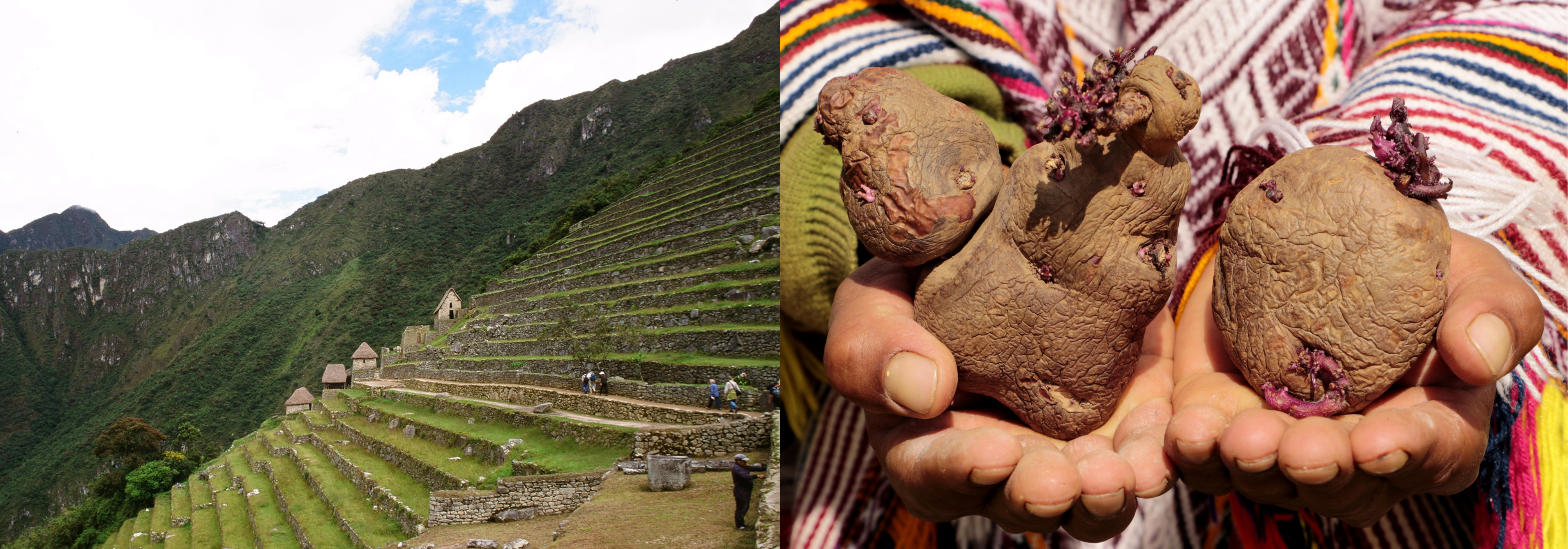
The Inca Empire (c. 1400 and 1533 CE) at its height extended across western South America from Southern Colombia and Ecuador in the north to Chile in the south. The Inca managed to thrive in the highlands of the Andes and the diverse surrounding environments that included plains, mountains, deserts, and tropical rainforests. Cuzco was the religious and administrative center of the empire, the navel of the Inca world radiating out highways, roads, and sacred sighting lines to each quarter (north, south, east, and west) of the Empire. The Inca network of roads covered over 40,000km, and although there were no wheeled vehicles, the road system was utilized by llamas and porters. It enabled the transportation of goods, armies, and messenger runners known as chasquis. Famed for their unique art and architecture, they constructed imposing stone buildings using massive stone blocks so precisely fit together that no mortar was needed. Impressive terraces, highways, and mountain-top buildings in the world-famous Machu-Picchu continue to inspire admiration for Inca architecture and ingenuity.
Agricultural successes underlie all great civilizations. Settled or partially settled agriculture was common practice in pre-colonial Middle and South America. The region is home to two of the world’s ancient cultural hearths, centers of innovation of the Neolithic Revolution (10,000 BP) where agriculture began and diffused from. Unlike other cultural hearths of the world that primarily emerged along fertile river valleys, Mesoamerican and Andean civilizations harnessed diverse topographies and highlands. The two civilizations were mostly geographically disconnected by distance and the vast topographical barrier of the Andes Mountains south of the Panama Isthmus. Over millennia, Mesoamerican, Andean, and other Indigenous civilizations seized upon local innovations and mastered their environments with independent agricultural techniques that supported bountiful landscapes and rich food systems.
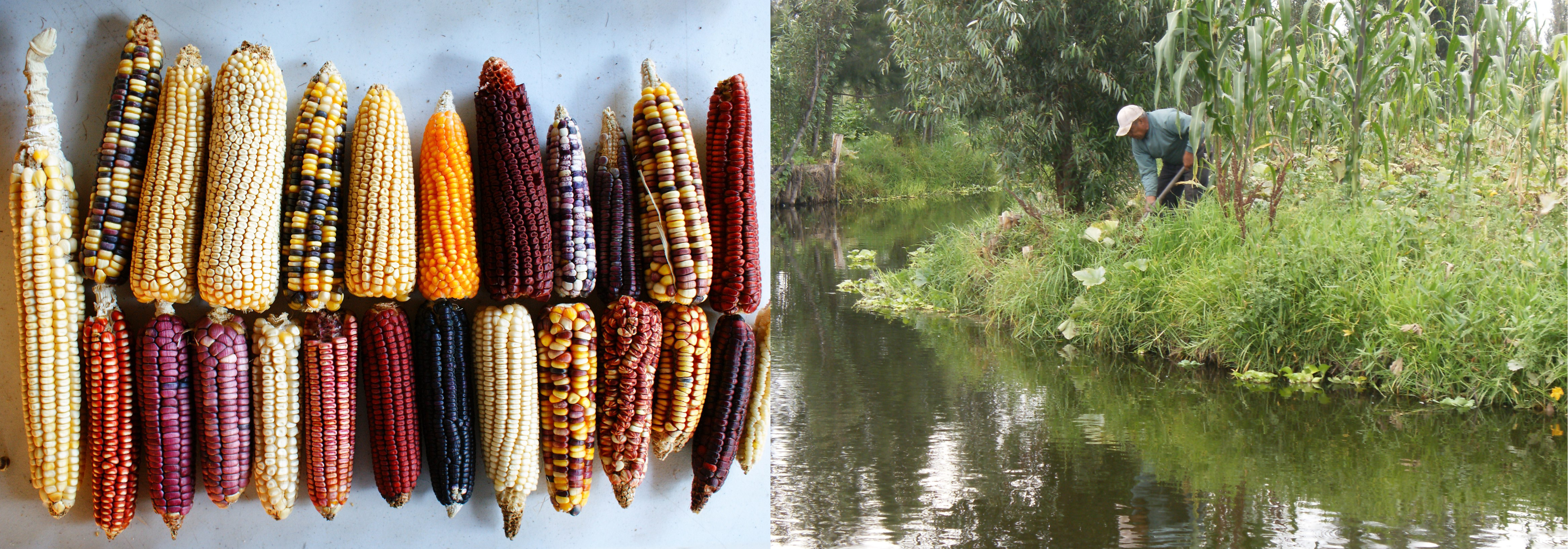
The Aztec inherited maize (corn) from their Mesoamerican predecessors. The domestication of maize around 6,000 years ago[4] is a feature of a breeding expertise that perplexes scientists because the crop that became a sacred foundation for great Indigenous civilizations is very different from its closest wild ancestor, a grass called teosinte. Over thousands of years, farmers in Mesoamerica bred teosinte into maize, cultivating varieties favorable to their local environments. Maize comes in blue, purple, orange, yellow, pink, black, and multicolored varieties that reflect the region’s immense ecological and cultural diversity. It is a formidable example of human mastery, one that has been highly rewarding since the crop has been a staple in Mesoamerican diet for thousands of years. The traditional way of cultivating maize, the milpa, is a form of slash and burn agriculture practiced to this day. Farmers clear plots of land and burn the vegetation. The ashes fertilize the soils that are then cultivated with a variety of crops for several seasons, then left fallow for soil nutrients to be restored. The cultivation of maize together with the cultivation of varieties of beans, peppers, tomatoes, chilis, avocados, squash, the highly prestigious cacao and chia, and the harvesting of insects and spirulina, gave Mesoamericans a diverse and nutritious diet.
Mesoamericans also developed the highly productive chinampas. These are raised agricultural fields that look like floating gardens, but they are more like artificial agricultural islands in wetlands or lake shorelines. Chinampas are built by adding layers of collected mud and vegetation atop a reed structure that is anchored by using stakes and willow trees. The plots are spaced by canals that allow access to fish and are easily accessible by canoes. This system essentially brings agriculture to water instead of the other way around. The water around each chinampa acts as a temperature moderator, a valuable feature given the drastic temperature changes of the highland environment of the Mexican plateau. Chinampa fertility has been historically managed by the harvest and application of lake sediment and organic waste, including human waste. This lakeside agricultural system greatly increased the agricultural capacity of the land to support large populations in pre-Columbian Tenochtitlán. The use of chinampas dates to centuries ago and continues to this day. Other parts of Mesoamerica and South America use similar strategies. In the Peruvian and Bolivian altiplano, the practice of waru waru agriculture along Lake Titicaca is another example of raised field agriculture with similar techniques and benefits of the chinampas.
Along the Andes mountains, Indigenous farmers carved mountains into extensive hillside agricultural plots called terraces. Terraces are pronounced features of the cultural landscape in Andean South America, with thousands of kilometers of these structures carving mountain sides. Terracing maximizes land area for agriculture, turning steep hillsides into wide stone stairways that provide a flat surface to maximize solar exposure, water absorption, and reduce erosion in agricultural plots. They often included canals, as the Incas were experts at diverting water, carrying it across great distances, channeling it underground, and creating outlets and fountains. Andean farmers managed fertility by transporting fertile river soils to terraces and using compost. They also used human and llama manure, but nothing was quite as potent of a fertilizer as guano, the bird droppings mined in the coastal islands of Peru. The Inca harvested guano as fruits of their geography. The Peru Current flowing through their coasts is a cold oceanic current that pushes nutrient-rich waters that support rich fisheries in Chile and Peru to this day. The birds eat the fish, and the nearby islands where they breed became mining places for the potent dung that became the most important fertilizers of Inca agriculture. Guano was strictly regulated by the Inca empire, and the droppings were precious trade commodities.
Terracing was also an important strategy to harness the various microclimates of the Andes. As altitude increases, temperature decreases, and thus each altitudinal zone can support different crops and animals, something known as altitudinal zonation. The hot, coastal area known as tierra caliente (from sea level to 2,500 feet) can support tropical crops like bananas, manioc, sweet potatoes, and beans. Tierra templada (2,501 – 6,000 feet) has cooler temperatures optimal for an array of crops like corn, coffee, and vegetables. Tierra fria (6,001 – 12,000 feet) is the highest altitude for most trees but various crops do well in these cooler temperatures, including wheat, barley, and quinoa. Past the tree line in the higher elevation of the tierra helada, animals like llamas can graze on cool grasses. There are few crops that grow in high elevations. Nevertheless, Andean farmers domesticated the potato, a hardy crop that can grow at altitudes well past 12,000 feet. The starchy crop is high in calories, can be stored underground, and withstands frost. They are the staple of the Andean diet. Together with the protein-rich quinoa, also domesticated in the Andes, these highland crops provide nutritious foods that are well adapted to the Andes.
Colonization
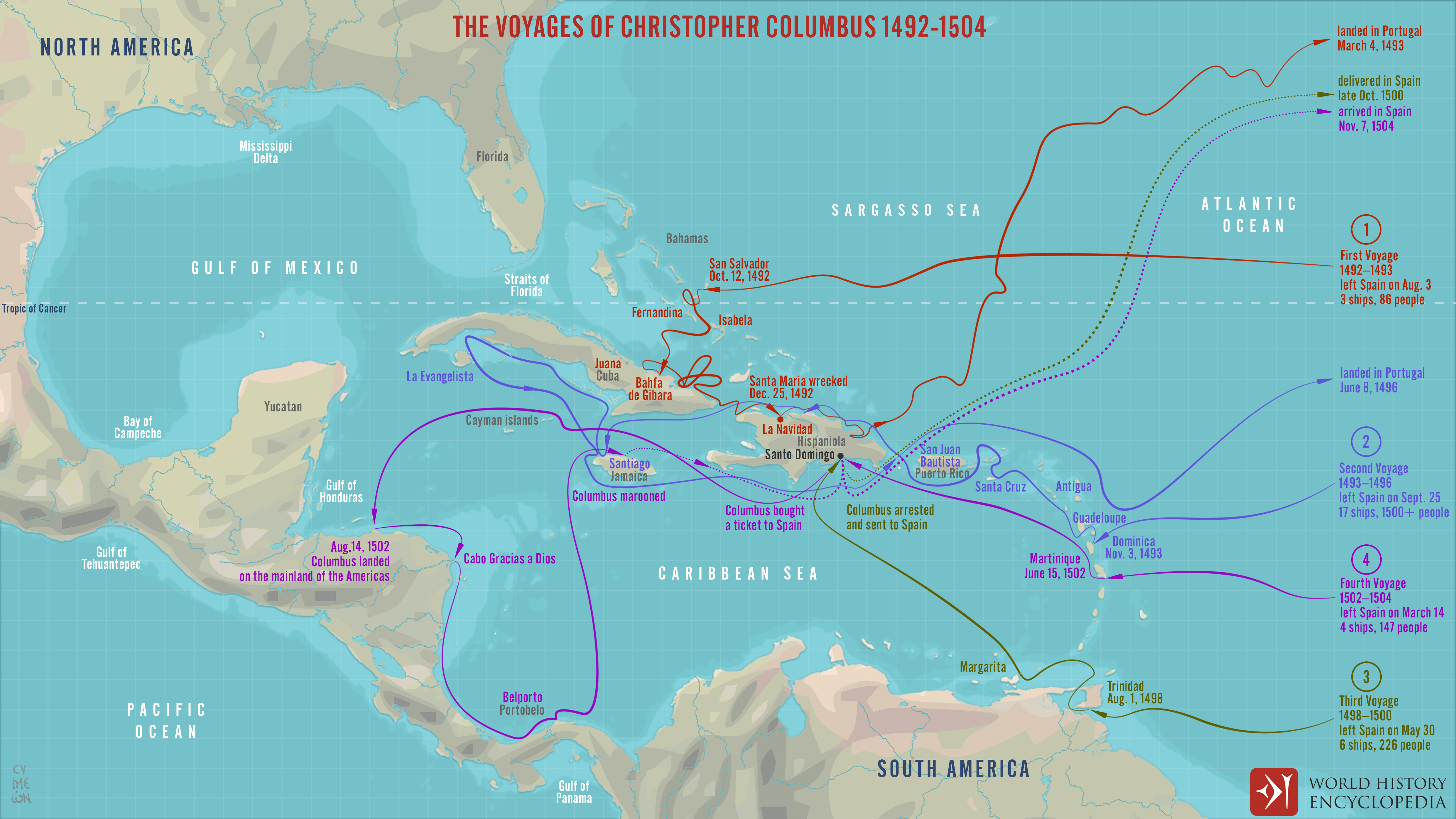
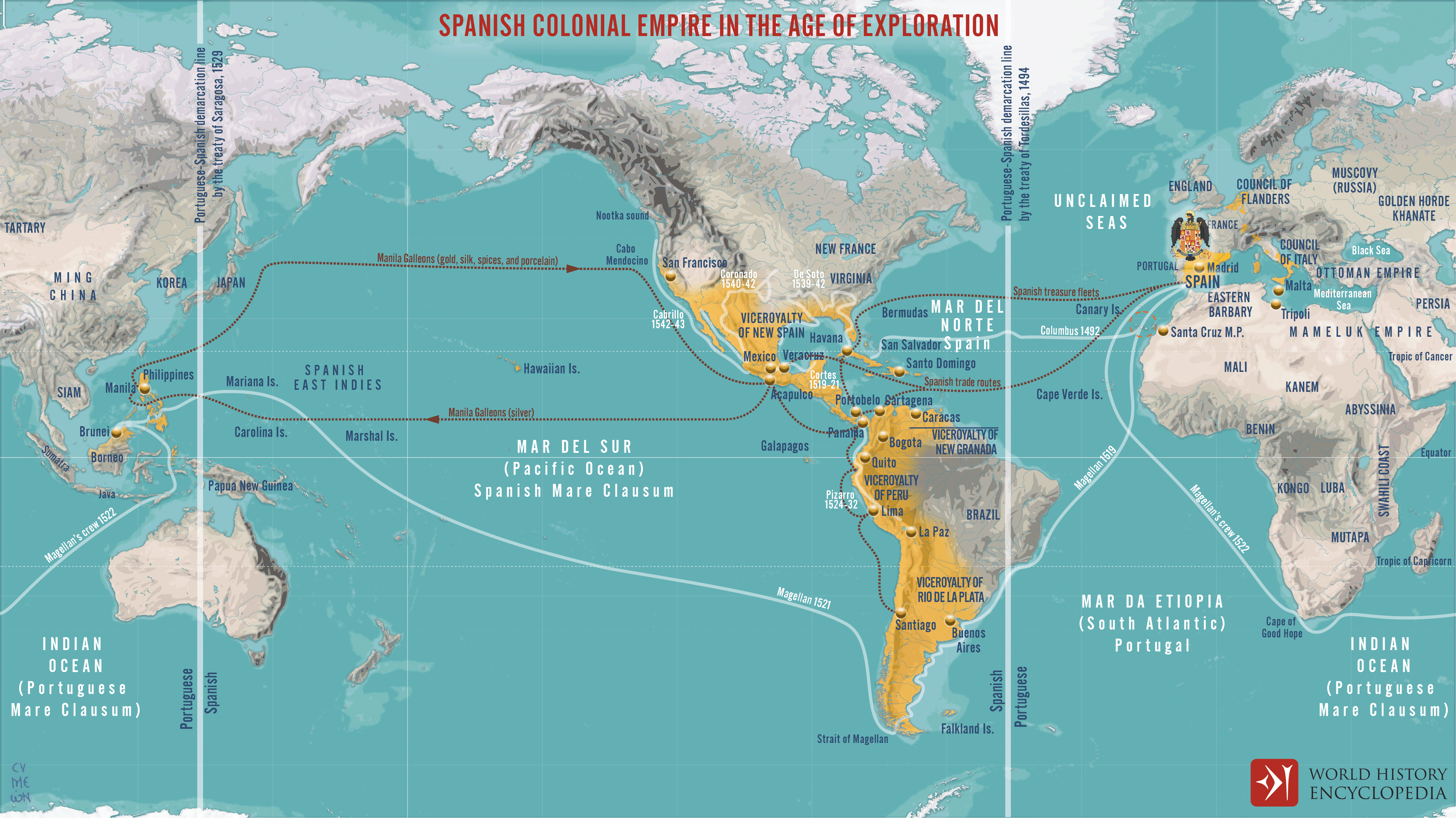
European colonization started with Christopher Columbus (1451-1506) who landed in the Caribbean in 1492, first in the Bahamas then Cuba and Hispaniola, introducing the Americas to the European map. Sailing for Spain, Columbus stumbled upon the continent seeking a new maritime route to Asia to access the riches of the East. Columbus opened the way for Spanish colonists to settle in the region, along with the English, French, Dutch, and other Europeans. The arms race to colonize the Americas led to the Treaty of Tordesillas (1494), an arbitrary line demarcating the Spanish and Portuguese spheres of influence in the Americas (see maps 9.2.3). The Spanish would control territory to the west of the line while Portugal would control territory to the east.
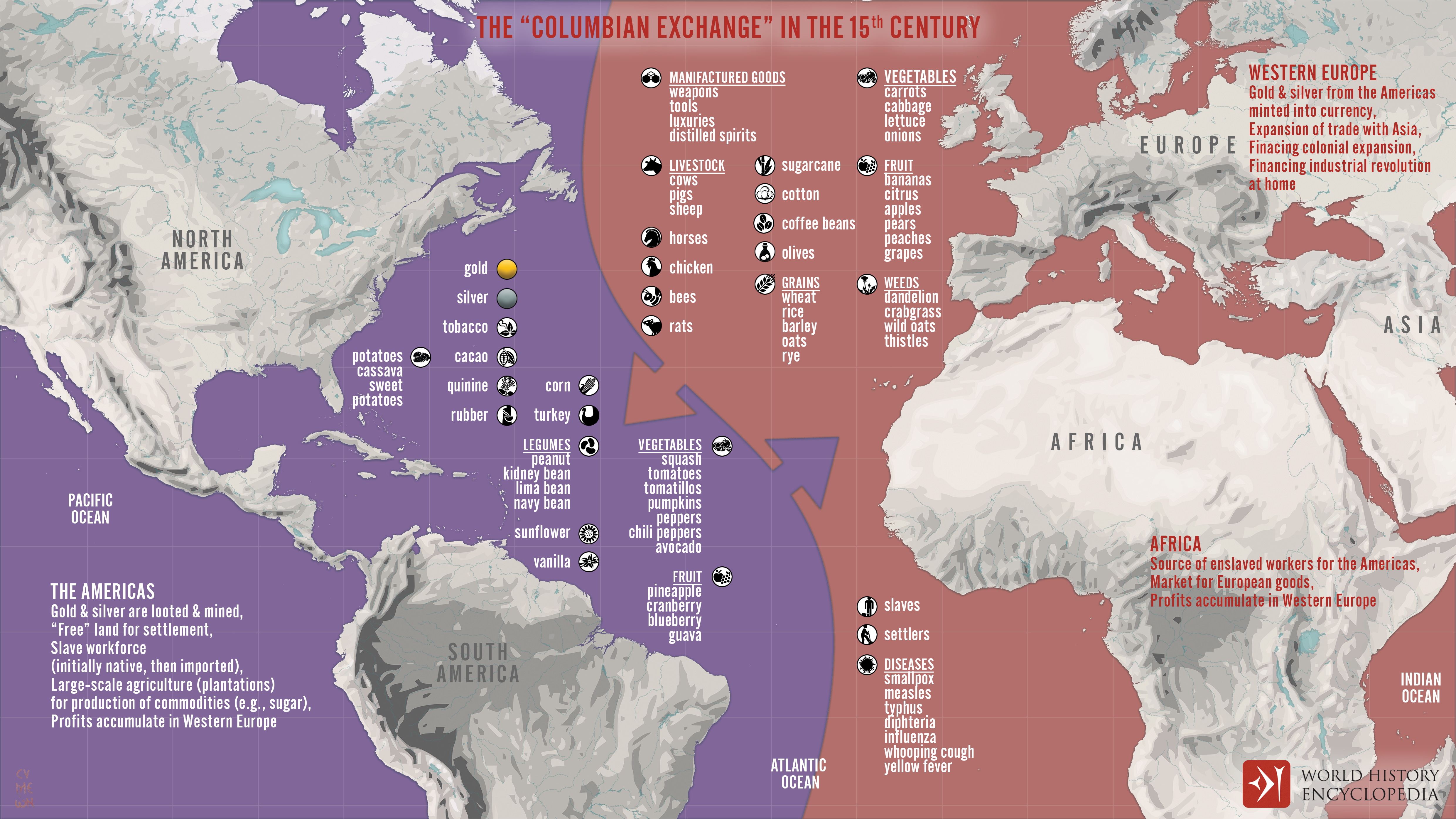
The Columbian Exchange
The arrival of Columbus and the subsequent colonization initiated an ongoing transformation of the Americas. One of the earliest and most dramatic was the impacts of the exchanges of plants, animals, and diseases from once-separate worlds, known as the Columbian exchange. Europeans brought domesticated animals like the horse, sheep, cattle, goats, and pigs. They also brought crops like wheat, olives, rice, grapes, citrus, sugarcane, and coffee. From the Americas, maize, potatoes, tomatoes, peanuts, tobacco, and cacao were among the plants that journeyed across the Atlantic. Tobacco, traditionally smoked by Native Americans, became a valuable cash crop in Europe. Seen as a food of the gods, cacao was a crop with a long history of prestige among Mesoamerican civilizations. It was usually ground into a powder and infused into water to make a bitter ceremonious drink called xocóatl. Spaniards disliked its bitterness, and eventually added sugar, honey, and vanilla, making the luxurious chocolate most people love to this day. It is the potato, however, that had arguably the biggest impact. As a subsurface tuber, potatoes allowed the conquered to survive the various European wars, whereas in the past, the conquerors burned the crops as they left, and the people starved. Potatoes also consists of essential vitamins and nutrients and can grow in various soil types, cooler climates, and higher elevations. Its introduction ended centuries-old cycles of malnourishment and famine in Europe, increasing lifespans and fueling population growth.
The Columbian exchange is considered one of the most pivotal events in human history. It shifted diets all over the world, introducing crops that profoundly changed the agricultural landscapes and foodways of the Americas, Africa, and Europe. It also introduced alien microbes to the Americas that above all else led to the decimation of the Indigenous populations.
The Demographic Collapse & The Pristine Myth
The colonization of the Americas is sometimes attached to words like “encounter,” “discovery,” or even “the age of exploration.” These are curious terms to describe the cataclysm unleashed onto the Indigenous worlds of the Americas (and other places “explored” during the colonial era). The European invasion resulted in a collapse of Indigenous populations due to slavery, warfare, famine, and the introduction of diseases like smallpox, measles, influenza, and the bubonic plague were introduced to the Americas by European settlers and enslaved Africans. Most of these diseases originated from domesticated farm animals, something that Indigenous populations had no previous exposure to. American civilizations had low numbers of domesticated animals and therefore did not have such diseases to transmit to Europeans. Thus, European diseases ravaged the Americas, not vice versa.[5] Each of these diseases typically killed about 30 percent or more of the initial population, so a series of epidemics in rapid succession could have led to the loss of whole societies. These are called virgin soil epidemics because new pathogens were introduced to an entire population that had not been exposed to such pathogens and therefore did not yet possess the antibodies to survive them. Within 150 years of European contact, 90-95 percent of the Indigenous population in the Americas died. In the Caribbean, about 99 percent of the Indigenous inhabitants died.[6] It is the most precipitous demographic collapse in recorded history. Mexico’s Central Valley, the most populous region in the Americas before colonization, did not reach its Pre-Columbian population again until the 20th Century.[7]
The large scale of human loss in vast areas meant that previously cultivated lands were emptied. This led to the pristine myth, or the idea that a vast pristine wilderness existed in the Pre-Columbian Americas. In other words, the Americas were thought to be a land without people. In some areas, Europeans thought they had “discovered” empty wilderness, but evidence suggests that they actually encountered depopulated landscapes.[8] An army of pathogens swept through the Americas killing large shares of the Indigenous populations, many times ahead of European arrival. Vast landscapes were covered by vegetation growth that covered the evidence of human occupation that would later serve as cues to scientists piecing together the Pre-Columbian history of the Americas.

Contemporary Indigenous Populations
Indigenous peoples have undergone centuries of colonization and dispossession of their ancestral lands, and their struggle to exist carries on to this day. Miscegenation (discussed in Section 9.3) and cultural repression and change have resulted in the erosion of Indigenous languages and traditions. Increasingly, native languages are being replaced by Spanish and Portuguese, especially among younger generations. Nonetheless, there are large Indigenous populations in many parts of the Americas where Indigenous peoples maintain and increasingly reclaim their identities. The largest population clusters are found in Mesoamerica (Mexico and Guatemala) and Andean South America (Ecuador, Peru, Bolivia). The most spoken languages are Nahuatl (Mexico’s Central Valley), Quechua (Andean South America), and Tupi-Guarani (Brazil & Bolivia).

Determining the exact number and distribution of Indigenous peoples in Middle and South America is difficult for various reasons. The main challenge is related to the very politicized nature of recognizing Indigenous identities. Indigenous peoples often rely on their official recognition to be protected from or included in aspects of decision making that could affect their lives, assets, and cultures. Thus, the politics of indigeneity, the recognition of who is and who is not Indigenous, has become increasingly relevant and controversial in recent decades largely because of new legal frameworks and international agreements safeguarding Indigenous rights. For example, in Venezuela, the 1999 constitution included, for the first time, the full status of adult citizens to Indigenous peoples with added special provisions for the protection of their cultures, languages, territories, natural resources, customary forms of social order, and health. The constitutional changes overrode the 1915 Missions’ Law that delegated the responsibility to the Catholic Church to oversee the basic civil rights of Indigenous people. As a result of recognized rights, more people self-identified as Indigenous in the census. In the Caribbean, where Indigenous peoples were long thought to have been extinct, many Taíno descendants are rejecting invisibility and asserted their cultural existence and survival. In doing so, they contest erasure and provoke lively discussions about who can claim indigeneity and what it means to be Indigenous in the Caribbean today.[9] [10]

References:
[1] Koch, A., Brierley, C., Maslin, M. M., & Lewis, S. L. (2019). Earth system impacts of the European arrival and Great Dying in the Americas after 1492. Quaternary Science Reviews, 207, 13-36.
[2] Miller, S. W. (2007). An environmental history of Latin America. Cambridge University Press. pp 10-11.
[3] Diamond’s Collapse.
[4] del Castillo, R. F., & Rivera-García, R. (2022). Biophysical and Biocultural Upheavals in Mesoamerica, a Conservation Perspective: Mountains, Maize-Milpa, and Globalization. Frontiers in Forests and Global Change, 5, 763009.
[5] With exceptions like syphilis, which is of American origin. Nonetheless, it did not result in a demographic collapse in Europe in comparable ways. The exchange of diseases and their impacts are incomparable.
[6] Koch, A., Brierley, C., Maslin, M. M., & Lewis, S. L. (2019). Earth system impacts of the European arrival and Great Dying in the Americas after 1492. Quaternary Science Reviews, 207, 13-36.
[7] Miller, S. W. (2007). An environmental history of Latin America. Cambridge University Press. pp 10-11.
[8] Denevan, W. M. (2011). The “pristine myth” revisited. Geographical Review, 101(4), 576-591.
[9] Feliciano-Santos, S. (2021). A Contested Caribbean Indigeneity: Language, Social Practice, and Identity Within Puerto Rican Taíno Activism. Rutgers University Press.
[10] Woodaman, R. (Dec 28, 2017). Bringing Taíno peoples back into history. The Smithsonian Magazine.
Attributions:
"Mesoamerican Civilizations" is adapted from Maya Civilization by Joshua Mark and Aztec Empire, Aztec Food and Agriculture, Tenochtitlan, and Inca Civilization by Mark Cartwright via World History Encyclopedia, CC BY-NC-SA 4.0.
"Colonization" is adapted from European Colonization of the Americas by Joshua J. Mark via World History Encyclopedia, CC BY-NC-SA 4.0.
"The Columbian Exchange" is adapted from Columbian Exchange by John Horgan, CC BY-NC-SA 4.0 and Earth system impacts of the European arrival and Great Dying in the Americas after 1492 by Koch, A., Brierley, C., Maslin, M. M., & Lewis, S. L. (2019) via Quaternary Science Reviews, CC BY 4.0.
This page is also adapted from World Regional Geography by University of Minnesota and World Regional Geography by Caitlin Finlayson, both CC BY-NC-SA 4.0.