1.4: The Physical Setting
- Page ID
- 21049
\( \newcommand{\vecs}[1]{\overset { \scriptstyle \rightharpoonup} {\mathbf{#1}} } \)
\( \newcommand{\vecd}[1]{\overset{-\!-\!\rightharpoonup}{\vphantom{a}\smash {#1}}} \)
\( \newcommand{\dsum}{\displaystyle\sum\limits} \)
\( \newcommand{\dint}{\displaystyle\int\limits} \)
\( \newcommand{\dlim}{\displaystyle\lim\limits} \)
\( \newcommand{\id}{\mathrm{id}}\) \( \newcommand{\Span}{\mathrm{span}}\)
( \newcommand{\kernel}{\mathrm{null}\,}\) \( \newcommand{\range}{\mathrm{range}\,}\)
\( \newcommand{\RealPart}{\mathrm{Re}}\) \( \newcommand{\ImaginaryPart}{\mathrm{Im}}\)
\( \newcommand{\Argument}{\mathrm{Arg}}\) \( \newcommand{\norm}[1]{\| #1 \|}\)
\( \newcommand{\inner}[2]{\langle #1, #2 \rangle}\)
\( \newcommand{\Span}{\mathrm{span}}\)
\( \newcommand{\id}{\mathrm{id}}\)
\( \newcommand{\Span}{\mathrm{span}}\)
\( \newcommand{\kernel}{\mathrm{null}\,}\)
\( \newcommand{\range}{\mathrm{range}\,}\)
\( \newcommand{\RealPart}{\mathrm{Re}}\)
\( \newcommand{\ImaginaryPart}{\mathrm{Im}}\)
\( \newcommand{\Argument}{\mathrm{Arg}}\)
\( \newcommand{\norm}[1]{\| #1 \|}\)
\( \newcommand{\inner}[2]{\langle #1, #2 \rangle}\)
\( \newcommand{\Span}{\mathrm{span}}\) \( \newcommand{\AA}{\unicode[.8,0]{x212B}}\)
\( \newcommand{\vectorA}[1]{\vec{#1}} % arrow\)
\( \newcommand{\vectorAt}[1]{\vec{\text{#1}}} % arrow\)
\( \newcommand{\vectorB}[1]{\overset { \scriptstyle \rightharpoonup} {\mathbf{#1}} } \)
\( \newcommand{\vectorC}[1]{\textbf{#1}} \)
\( \newcommand{\vectorD}[1]{\overrightarrow{#1}} \)
\( \newcommand{\vectorDt}[1]{\overrightarrow{\text{#1}}} \)
\( \newcommand{\vectE}[1]{\overset{-\!-\!\rightharpoonup}{\vphantom{a}\smash{\mathbf {#1}}}} \)
\( \newcommand{\vecs}[1]{\overset { \scriptstyle \rightharpoonup} {\mathbf{#1}} } \)
\(\newcommand{\longvect}{\overrightarrow}\)
\( \newcommand{\vecd}[1]{\overset{-\!-\!\rightharpoonup}{\vphantom{a}\smash {#1}}} \)
\(\newcommand{\avec}{\mathbf a}\) \(\newcommand{\bvec}{\mathbf b}\) \(\newcommand{\cvec}{\mathbf c}\) \(\newcommand{\dvec}{\mathbf d}\) \(\newcommand{\dtil}{\widetilde{\mathbf d}}\) \(\newcommand{\evec}{\mathbf e}\) \(\newcommand{\fvec}{\mathbf f}\) \(\newcommand{\nvec}{\mathbf n}\) \(\newcommand{\pvec}{\mathbf p}\) \(\newcommand{\qvec}{\mathbf q}\) \(\newcommand{\svec}{\mathbf s}\) \(\newcommand{\tvec}{\mathbf t}\) \(\newcommand{\uvec}{\mathbf u}\) \(\newcommand{\vvec}{\mathbf v}\) \(\newcommand{\wvec}{\mathbf w}\) \(\newcommand{\xvec}{\mathbf x}\) \(\newcommand{\yvec}{\mathbf y}\) \(\newcommand{\zvec}{\mathbf z}\) \(\newcommand{\rvec}{\mathbf r}\) \(\newcommand{\mvec}{\mathbf m}\) \(\newcommand{\zerovec}{\mathbf 0}\) \(\newcommand{\onevec}{\mathbf 1}\) \(\newcommand{\real}{\mathbb R}\) \(\newcommand{\twovec}[2]{\left[\begin{array}{r}#1 \\ #2 \end{array}\right]}\) \(\newcommand{\ctwovec}[2]{\left[\begin{array}{c}#1 \\ #2 \end{array}\right]}\) \(\newcommand{\threevec}[3]{\left[\begin{array}{r}#1 \\ #2 \\ #3 \end{array}\right]}\) \(\newcommand{\cthreevec}[3]{\left[\begin{array}{c}#1 \\ #2 \\ #3 \end{array}\right]}\) \(\newcommand{\fourvec}[4]{\left[\begin{array}{r}#1 \\ #2 \\ #3 \\ #4 \end{array}\right]}\) \(\newcommand{\cfourvec}[4]{\left[\begin{array}{c}#1 \\ #2 \\ #3 \\ #4 \end{array}\right]}\) \(\newcommand{\fivevec}[5]{\left[\begin{array}{r}#1 \\ #2 \\ #3 \\ #4 \\ #5 \\ \end{array}\right]}\) \(\newcommand{\cfivevec}[5]{\left[\begin{array}{c}#1 \\ #2 \\ #3 \\ #4 \\ #5 \\ \end{array}\right]}\) \(\newcommand{\mattwo}[4]{\left[\begin{array}{rr}#1 \amp #2 \\ #3 \amp #4 \\ \end{array}\right]}\) \(\newcommand{\laspan}[1]{\text{Span}\{#1\}}\) \(\newcommand{\bcal}{\cal B}\) \(\newcommand{\ccal}{\cal C}\) \(\newcommand{\scal}{\cal S}\) \(\newcommand{\wcal}{\cal W}\) \(\newcommand{\ecal}{\cal E}\) \(\newcommand{\coords}[2]{\left\{#1\right\}_{#2}}\) \(\newcommand{\gray}[1]{\color{gray}{#1}}\) \(\newcommand{\lgray}[1]{\color{lightgray}{#1}}\) \(\newcommand{\rank}{\operatorname{rank}}\) \(\newcommand{\row}{\text{Row}}\) \(\newcommand{\col}{\text{Col}}\) \(\renewcommand{\row}{\text{Row}}\) \(\newcommand{\nul}{\text{Nul}}\) \(\newcommand{\var}{\text{Var}}\) \(\newcommand{\corr}{\text{corr}}\) \(\newcommand{\len}[1]{\left|#1\right|}\) \(\newcommand{\bbar}{\overline{\bvec}}\) \(\newcommand{\bhat}{\widehat{\bvec}}\) \(\newcommand{\bperp}{\bvec^\perp}\) \(\newcommand{\xhat}{\widehat{\xvec}}\) \(\newcommand{\vhat}{\widehat{\vvec}}\) \(\newcommand{\uhat}{\widehat{\uvec}}\) \(\newcommand{\what}{\widehat{\wvec}}\) \(\newcommand{\Sighat}{\widehat{\Sigma}}\) \(\newcommand{\lt}{<}\) \(\newcommand{\gt}{>}\) \(\newcommand{\amp}{&}\) \(\definecolor{fillinmathshade}{gray}{0.9}\)When we describe places, we can discuss their absolute and relative location and their relationship and interaction with other places. As regional geographers, we can dig deeper and explore both the physical and human characteristics that make a particular place unique. Geographers explore a wide variety of spatial phenomena, but the discipline can roughly be divided into two branches: physical geography and human geography. Physical geography focuses on natural features and processes, such as landforms, climate, and water features. Human geography is concerned with human activity, such as culture, language, and religion. However, these branches are not exclusive. You might be a physical geographer who studies hurricanes, but your research includes the human impact from these events. You might be a human geographer who studies food, but your investigations include the ecological impact of agricultural systems. Regional geography takes this holistic approach, exploring both the physical and human characteristics of the world’s regions.
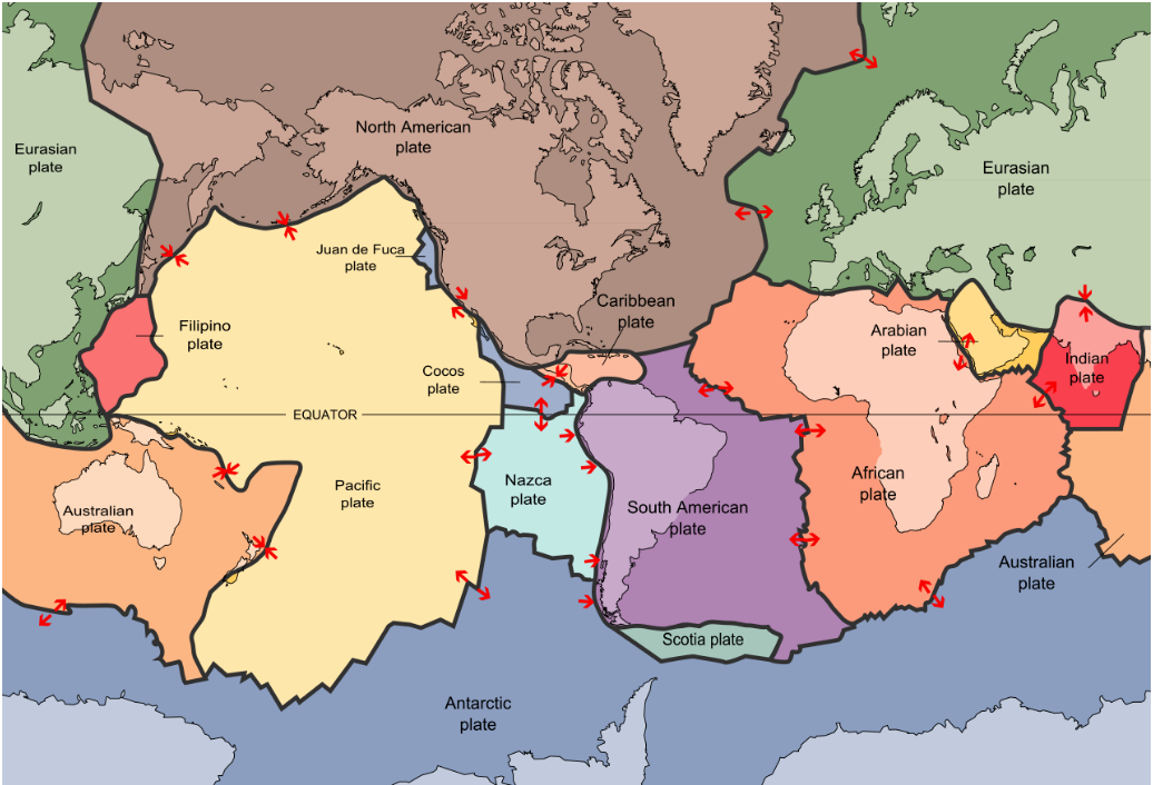
Much of Earth’s physical landscape, from mountains to volcanoes to earthquakes to valleys, has resulted from the movement of tectonic plates. As the theory of plate tectonics describes, these rigid plates are situated on top of a bed of molten, flowing material, much like a cork floating in a pot of boiling water. There are seven major tectonic plates and numerous minor plates (Figure \(\PageIndex{1}\)).

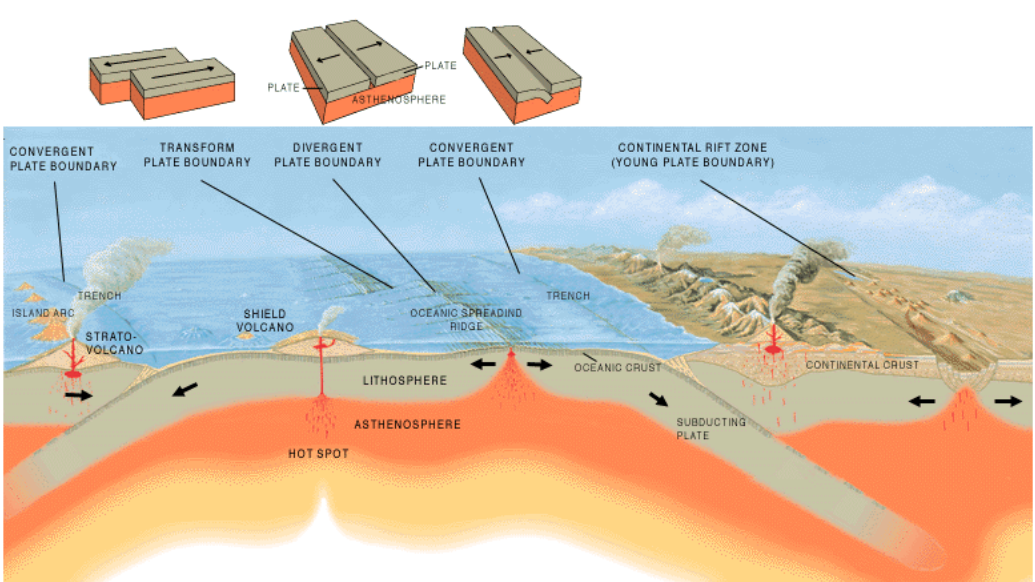
Where two tectonic plates meet is known as a plate boundary and boundaries can interact in three different ways (Figure \(\PageIndex{2}\)). Where two plates slide past one another is called a transform boundary. The San Andreas Fault in California is an example of a transform boundary. A divergent plate boundary is where two plates slide apart from one another. Africa’s Rift Valley was formed by this type of plate movement. Convergent plate boundaries occur when two plates slide towards one another. In this case, where two plates have roughly the same density, upward movement can occur, creating mountains. The Himalaya Mountains, for example, were formed from the Indian plate converging with the Eurasian plate. In other cases, subduction occurs and one plate slides below the other. Here, deep, under-ocean trenches can form. The 2004 Indian Ocean earthquake and tsunami occurred because of a subducting plate boundary off the west coast of Sumatra, Indonesia.

Interaction between tectonic plates and historical patterns of erosion and deposition have generated a variety of landforms across Earth’s surface. Each of the world’s regions has identifiable physical features, such as plains, valleys, mountains, and major water bodies. Topography refers to the study of the shape and features of the surface of the Earth. Areas of high relief have significant changes in elevation on the landscape, such as steep mountains, while areas of low relief are relatively flat.
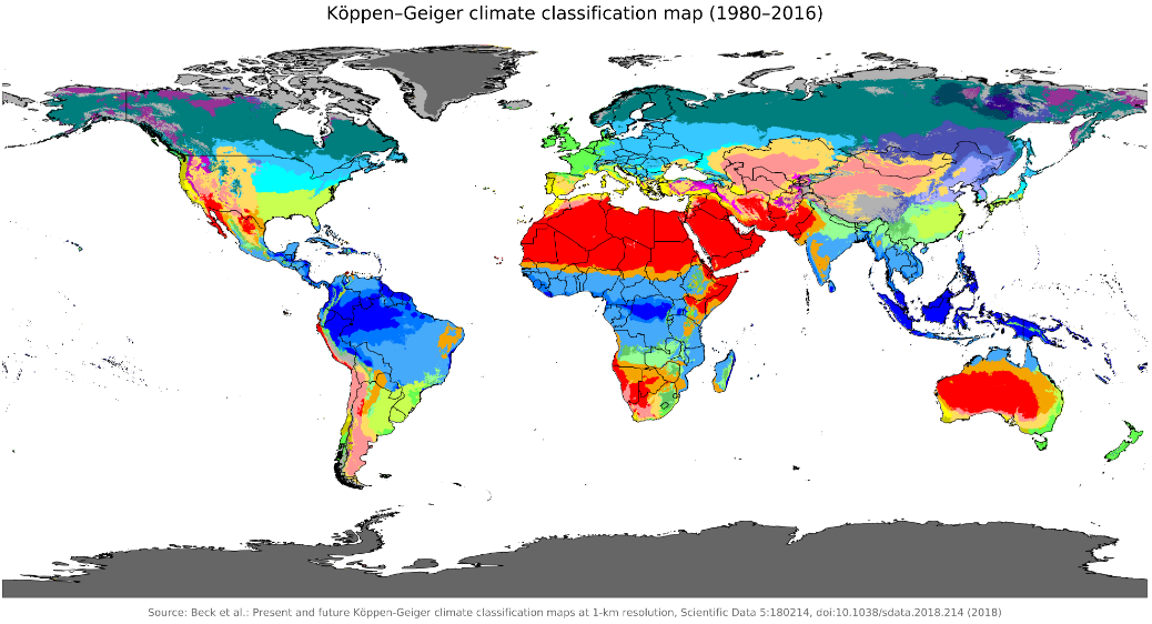
Another key feature of Earth’s physical landscape is climate. Weather refers to the short-term state of the atmosphere. We might refer to the weather as partly sunny or stormy, for example. Climate, on the other hand, refers to long-term weather patterns and is affected by a place’s latitude, terrain, altitude, and nearby water bodies. Explained another way, “weather” is what you’re wearing today while “climate” is all the clothes in your closet. Geographers commonly use the Köppen climate classification system to refer to the major climate zones found in the world (Figure \(\PageIndex{3}\)).

Each climate zone in the Köppen climate classification system is assigned a letteredcode, referring to the temperature and precipitation patterns found in the particular region. Climate varies widely across Earth. Cherrapunji, India, located in the Cwb climate zone, receives over 11,000 mm (400 in) of rain each year. In contrast, the Atacama Desert (BWk), situated along the western coast of South America across Chile, Peru, Bolivia, and Argentina, typically receives only around 1 to 3 mm (0.04 to 0.12 in) of rain each year.
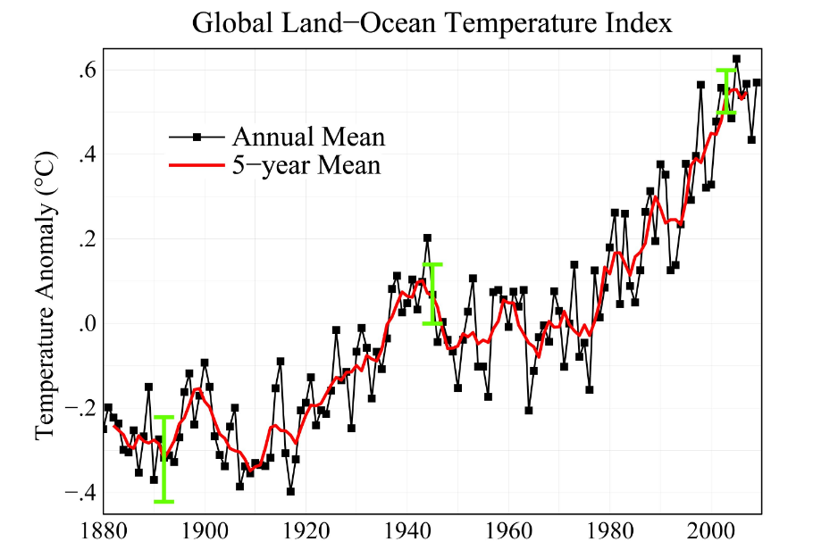
Earth’s climate has gone through significant changes historically, alternating between long periods of warming and cooling. Since the industrial revolution in the 1800s, however, global climate has experienced a warming phase. 95 percent of scientists agree that this global climate change has resulted primarily from human activities, particularly the emission of greenhouse gases like carbon dioxide (Figure \(\PageIndex{4}\)). 17 of the 18 warmest years ever recorded have occurred since 2000. Overall, this warming has contributed to rising sea levels as the polar ice caps melt, changing precipitation patterns, and the expansion of deserts. The responses to global climate change, and the impacts from it, vary by region.

- Plate Tectonics:
-
a theory that describes the movement of rigid, tectonic plates above a bed of molten, flowing material
- Climate Change:
-
global changes in temperature and the patterns of weather over an extended period of time


